
Viljandi County
Viljandi County | |
|---|---|
 | |
 Coat of arms | |
 | |
| Country | Estonia |
| Capital | Viljandi |
| Government | |
| • Governor | Lembit Kruuse |
| Area | |
| • Total | 3,422.49 km2 (1,321.43 sq mi) |
| Population (Jan 2017) | |
| • Total | 48,101 |
| • Rank | 6th |
| • Density | 14/km2 (36/sq mi) |
| Ethnicity | |
| • Estonians | 95.4% |
| • Russians | 2.5% |
| • other | 2.9% |
| ISO 3166 code | EE-84 |
| Vehicle registration | D |
| Website | www |

Viljandi County (Estonian: Viljandi maakond or Viljandimaa, German: Kreis Fellin), is one of 15 counties of Estonia. It is located in southern Estonia bordering Pärnu, Järva, Jõgeva, Tartu and Valga counties.
History
Viljandimaa, under the German name of Kreis Fellin, was an important centre of commerce and power in the Middle Ages. Today, there are a number of castle ruins there dating from this time.
Soomaa National Park is a national park located partially within Viljandi County, Estonia. Soomaa ("land of bogs") protects 390 km², and is a Ramsar site of protected wetlands. The park was created in 1993.[1]
County government
The County government (Estonian: Maavalitsus) is led by Governor (Estonian: maavanem), who is appointed by the Government of Estonia for a term of five years. Currently the Governor position is held by Kalle Küttis.
Municipalities
The county is subdivided into municipalities. There is 1 urban municipalities (Estonian: linnad – towns) and 3 rural municipalities (Estonian: vallad – parishes) in Viljandi County.
| Rank | Municipality | Type | Population (2018)[2] |
Area km2[2] |
Density[2] |
|---|---|---|---|---|---|
| 1 | Mulgi Parish | Rural | 7,652 | 881 | 8.7 |
| 2 | Põhja-Sakala Parish | Rural | 8,203 | 1,153 | 7.1 |
| 3 | Viljandi Parish | Rural | 13,950 | 1,374 | 10.2 |
| 4 | Viljandi | Urban | 17,758 | 15 | 1,183.9 |
Gallery
-
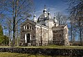 Arussaare orthodox church, built in 1873
 -
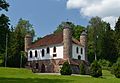
 Suure-Kõpu manor main building
 -
 Heimtali manor distillery kitchen
 -
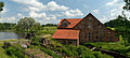
 Reservoir in the town of Suure-Jaani
 -
 Võrtsjärv lake; view from the village of Valma
 -
 Ruins of Viljandi castle
 -
 Õisu manor watermill
 -
 St. John's Church in Viljandi


References
- ^ RMK: Soomaa National Park. Retrieved 25 January 2016.
- ^ a b c "Elanike demograafiline jaotus maakonniti". Kohaliku omavalitsuse portaal. Retrieved 2 April 2018.
External links
 Media related to Viljandi County at Wikimedia Commons
- Viljandimaa – Official website
- Viljandi County Government Template:Et icon
| Urban municipalities | ||
|---|---|---|
| Rural municipalities | ||