
Villeneuve-lès-Avignon
Villeneuve-lès-Avignon | |
|---|---|
 View of Villeneuve-lès-Avignon and the Fort Saint-André, by Jean-Baptiste-Camille Corot | |
Location of Villeneuve-lès-Avignon  | |
| Country | France |
| Region | Occitania |
| Department | Gard |
| Arrondissement | Nîmes |
| Canton | Villeneuve-lès-Avignon |
| Government | |
| • Mayor (2008–2014) | Jean-Marc Roubaud |
| Area 1 | 18.27 km2 (7.05 sq mi) |
| Population (2008) | 12,756 |
| • Density | 700/km2 (1,800/sq mi) |
| Time zone | UTC+01:00 (CET) |
| • Summer (DST) | UTC+02:00 (CEST) |
| INSEE/Postal code | 30351 /30400 |
| Elevation | 10–181 m (33–594 ft) (avg. 25 m or 82 ft) |
| 1 French Land Register data, which excludes lakes, ponds, glaciers > 1 km2 (0.386 sq mi or 247 acres) and river estuaries. | |
Villeneuve-lès-Avignon is a commune in the Gard department in southern France. It can also be spelled Villeneuve-lez-Avignon.
History
The city was founded by Philippe le Bel and boasts a castle he built, Fort Saint-André.
Geography
It is located by the Rhône River, opposite Avignon.
Population
| Year | Pop. | ±% |
|---|---|---|
| 1793 | 3,300 | — |
| 1800 | 3,297 | −0.1% |
| 1806 | 3,279 | −0.5% |
| 1821 | 3,232 | −1.4% |
| 1831 | 3,564 | +10.3% |
| 1836 | 3,633 | +1.9% |
| 1841 | 3,671 | +1.0% |
| 1846 | 3,723 | +1.4% |
| 1851 | 3,733 | +0.3% |
| 1856 | 3,252 | −12.9% |
| 1861 | 3,162 | −2.8% |
| 1866 | 3,067 | −3.0% |
| 1872 | 2,730 | −11.0% |
| 1876 | 2,910 | +6.6% |
| 1881 | 2,630 | −9.6% |
| 1886 | 2,644 | +0.5% |
| 1891 | 2,622 | −0.8% |
| 1896 | 2,735 | +4.3% |
| 1901 | 2,922 | +6.8% |
| 1906 | 2,890 | −1.1% |
| 1911 | 2,709 | −6.3% |
| 1921 | 2,561 | −5.5% |
| 1926 | 3,035 | +18.5% |
| 1931 | 3,635 | +19.8% |
| 1936 | 3,740 | +2.9% |
| 1946 | 4,399 | +17.6% |
| 1954 | 5,157 | +17.2% |
| 1962 | 6,422 | +24.5% |
| 1968 | 6,977 | +8.6% |
| 1975 | 8,540 | +22.4% |
| 1982 | 9,282 | +8.7% |
| 1990 | 10,730 | +15.6% |
| 1999 | 11,791 | +9.9% |
| 2008 | 12,756 | +8.2% |
Sights
International relations
Twin towns – Sister cities
Villeneuve-lès-Avignon is twinned with:
Gallery
-

-

-
 Chartreuse du Val de Bénédiction
 -
 Collapsed apse of church, Chartreuse du Val de Bénédiction
 -
 Cloister of Saint John, Chartreuse du Val de Bénédiction
 -
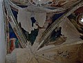 Chapel of the frescos, Chartreuse du Val de Bénédiction
 -
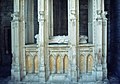 Tomb of Pope Innocent VI, Chartreuse du Val de Bénédiction


See also
References
External links
Wikimedia Commons has media related to Villeneuve-lès-Avignon.
This Gard geographical article is a stub. You can help Wikipedia by expanding it. |