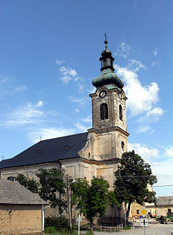
Vyšný Medzev
Vyšný Medzev
Obermetzenseifen | |
|---|---|
Village | |
 Church of Saint Mary Magdalene | |
| Coordinates: 48°43′10″N 20°54′30″E / 48.71944°N 20.90833°E | |
| Country | Slovakia |
| Region | Košice |
| District | Košice-okolie |
| First mentioned | 1427 |
| Area | |
| • Total | 32.43[2] km2 (12.52[2] sq mi) |
| Elevation | 387[3] m (1,270[3] ft) |
| Population (2021) | |
| • Total | 523[1] |
| Postal code | 044 25[3] |
| Area code | +421 55[3] |
| Car plate | KS |
Vyšný Medzev (German: Obermetzenseifen; Hungarian: Felsőmecenzéf) is a village and municipality of Košice-okolie District in the Košice Region of eastern Slovakia. It is one of several towns in Bodva Valley. Other towns in Bodva Valley include: Jasov, Lucia Bania, Medzev (Metzenseifen), and Stos.
History
[edit]Origins
[edit]The Settlers
[edit]It seems almost a certainty, that the farmers, especially those from Thuringia from “Das Dörfl”, moved to Vyšný Medzev ("Upper Metzenseifen"), or then named German: Obermetzenseifen, during the first lineage of farmers and as a minority compared to the miners, whose home lies in the Bodwa Valley in Medzev, or then known as German: Metzenseifen. Until 1427, there was a mere mention of a town in the Jasov monastery's documents (Kauer, J. et al. 1986). It is no wonder then, that the Premonstratensian Order—the "white" fathers—assumed religious control of this area. They favored the "Obere Ort" most likely due to the good relationship between the monastery in Jasov and its near proximity to the Lucia Mountain Mine.
Official Recognition
[edit]The contract, related to the mentioned town in 1427, was signed by the abbot of the monastery in Jasov on October 21, 1430. The vicar Johann from Vyšný Medzev, the judge Michael Swrger (later Schürger), the sworn in Hannus Nykel, Closperges and Cristan Lewberth and other invited townsmen were present at the signing.[5]
Geography
[edit]The village lies at an altitude of 383 metres and covers an area of 32.345 km². It has a population of 533 people.
External links
[edit]- http://www.oldmetzenseifen.de (Historical and genealogical website)
Notes
[edit]- ^ "Počet obyvateľov podľa pohlavia - obce (ročne)". www.statistics.sk (in Slovak). Statistical Office of the Slovak Republic. 2022-03-31. Retrieved 2022-03-31.
- ^ a b "Hustota obyvateľstva - obce [om7014rr_ukaz: Rozloha (Štvorcový meter)]". www.statistics.sk (in Slovak). Statistical Office of the Slovak Republic. 2022-03-31. Retrieved 2022-03-31.
- ^ a b c d "Základná charakteristika". www.statistics.sk (in Slovak). Statistical Office of the Slovak Republic. 2015-04-17. Retrieved 2022-03-31.
- ^ a b "Hustota obyvateľstva - obce". www.statistics.sk (in Slovak). Statistical Office of the Slovak Republic. 2022-03-31. Retrieved 2022-03-31.
- ^ Kauer, J., Schürger, J. and Wagner, K. 1986, ch. 8
References
[edit]- Kauer, J., Schürger, J. and Wagner, K. (1986). "Unter- und Ober-Metzenseifen Stoß Unterzips—Ostslowakei," Hilfsbund Karpatendeutscher Katholiken e.V., Arbeitskreis Bodwatal.

