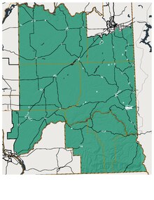
Washington's 9th legislative district
Appearance

Washington's 9th Legislative District is one of forty-nine districts in Washington state for representation in the state legislature. The sprawling rural district includes all of Adams, Asotin, Franklin, Garfield, and Whitman counties as well as parts of Spokane County. The district resides in the extreme southeast of the state, bordering Oregon to the south and Idaho to the east.[1]
The mostly rural district is represented by state senator Mark Schoesler and state representatives Mary Dye (pos. 1) and Joe Schmick (pos. 2), all Republicans.
See also
- Washington State Redistricting Commission
- Washington State Legislature
- Washington State Senate
- Washington House of Representatives
References
- ^ "2011 Washington State Redistricting Commission website". Retrieved January 27, 2013.
