Westerly Downtown Historic District
Westerly Downtown Historic District | |
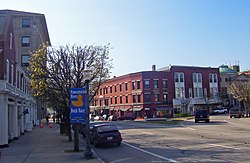
 View west along Broad Street (US 1 southbound), 2008 | |
| Location | Westerly, Rhode Island |
|---|---|
| Area | 24.7 acres (10.0 ha) |
| Built | 1840 |
| Architect | Multiple |
| Architectural style | Late 19th and 20th Century Revivals, Late Victorian, Art Deco |
| NRHP reference No. | 84002055 [1] (original) 95001288 (increase 1) 07001297 (increase 2) |
| Significant dates | |
| Added to NRHP | July 19, 1984 |
| Boundary increases | November 7, 1995 December 19, 2007 |
The Westerly Downtown Historic District is a historic district encompassing most of the commercial and civic business district of Westerly, Rhode Island, United States. It extends from Broad and Union Streets eastward along High Street, and north along Canal Street to Railroad Avenue, where it extends to include the historic railroad station. The district contains a compact and cohesive collection of commercial and civic buildings built primarily during the later part of the 19th and early part of the 20th century. Prominent buildings in the district include the Old Town Hall (1872–74), current Town Hall (1912), the Spanish Colonial railroad station (1912), and the Classical Revival Post Office.[2]
The district was listed on the National Register of Historic Places in 1984, with minor expansions in 1995 and 2007.[1]
See also
- Wilcox Park Historic District, which partially overlaps this district
- North End Historic District (Westerly, Rhode Island)
- National Register of Historic Places listings in Washington County, Rhode Island
References
- ^ a b "National Register Information System". National Register of Historic Places. National Park Service. January 23, 2007.
- ^ "Westerly Downtown Historic District" (PDF). Rhode Island Preservation. Retrieved 2014-08-13.
External links
- Westerly Pawcatuck Downtown Business Association
- Historic American Buildings Survey (HABS) No. RI-401, "Westerly Station, 14 Railroad Street, Westerly, Washington County, RI", 13 photos, 16 data pages, 2 photo caption pages
- U.S. Route 1
- Westerly, Rhode Island
- Historic districts in Washington County, Rhode Island
- Historic American Buildings Survey in Rhode Island
- Historic districts on the National Register of Historic Places in Rhode Island
- National Register of Historic Places in Washington County, Rhode Island
- Washington County, Rhode Island Registered Historic Place stubs

