Yeti Airlines Flight 101
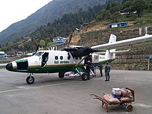
 9N-AFE at Lukla in 2007 | |
| Accident | |
|---|---|
| Date | 8 October 2008 |
| Summary | Controlled flight into terrain |
| Site | Lukla Airport, Nepal 27°41′13″N 086°43′47″E / 27.68694°N 86.72972°E |
| Flight origin | Kathmandu, Nepal |
| Destination | Lukla Airport, Nepal |
| Passengers | 16 |
| Crew | 3 |
| Fatalities | 18 |
| Survivors | 1 |
Yeti Airlines Flight 103 was a De Havilland Canada DHC-6 Twin Otter Series 300 registered as 9N-AFE. The flight crashed on final approach to Tenzing-Hillary Airport in the town of Lukla in eastern Nepal on 8 October 2008. The flight originated from Tribhuvan International Airport in Kathmandu.[1]

Crash
The airport is the main access to the Mount Everest region in Nepal, and is a notoriously difficult landing, with only 1,500 feet (460 m) of steeply sloped runway just 65 feet (20 m) wide and a steep approach path.[2] Due to bad weather conditions and heavy fog, the pilot could not see anything but still tried to land. He came in too low and too far left, which caused the aircraft to crash into the mountain.
Eighteen of the dead were reported to be tourists. Twelve of the passengers on the flight were German and two Australian. The only survivor was Surendra Kunwar; the captain of the aircraft, who was dragged free from the wreckage shortly after the crash and was flown out to Kathmandu for emergency treatment.[1][3][4]
References
- ^ a b Urs Wildermuth "Crash: Yeti Airlines DHC6 at Lukla, on October 8th, 2008, crashed on runway" Aviation Herald 8 October 2008
- ^ "Everest plane crash kills 18 tourists in Nepal" Agence France-Presse 8 October 2008
- ^ Bloomberg: Nepal Plane Crash Kills 18; Most Were German Tourists 8 October 2008
- ^ Matt Johnston, David Hastie "Everest plane crash claims Australian couple" Herald Sun 9 October 2008
External links
 Media related to Yeti Airlines Flight 103 at Wikimedia Commons
