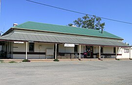
Yunta, South Australia
| Yunta South Australia | |
|---|---|
 The hotel at Yunta | |
| Coordinates | 32°35′S 139°34′E / 32.58°S 139.56°E |
| Population | 104 (2006 census)[1] |
| Established | 1887 |
| Postcode(s) | 5440 |
| Elevation | 305 m (1,001 ft) |
| Time zone | ACST (UTC+9:30) |
| • Summer (DST) | ACDT (UTC+10:30) |
| Location |
|
| LGA(s) | Outback Communities Authority |
| State electorate(s) | Stuart |
| Federal division(s) | Grey |
Yunta is a village in the Far North region of South Australia that services both the local area and travellers passing through on the Barrier Highway. It lies south west of Broken Hill and north east of Peterborough.
Yanta was an early spelling. In 1866 the district was known as part of the Tattawappa and Yanta Run.[2] Yunta township was established in 1887 after the discovery of gold at the nearby diggings at Teetulpa and Waukaringa, when more than 5,000 miners made their way through here. In the early 1890s the village was a busy railway town on the Adelaide to Broken Hill line. From 1934 Yunta was the base for the famed outback trucking and mail contractor Harry Ding.[3]
Today Yunta is a small service centre for travellers and the surrounding properties. Yunta also provides an alternate route to the Flinders Ranges and beyond. The natural gas fields at Gidgealpa and Moomba have resulted in improved access roads to South Australia's arid north-east region.[4]
Village facilities include a hotel offering meals and accommodation, two roadhouses (one with caravan sites), two fuel stations, post office, Rural Transaction Centre offering internet access, police station, air strip and a primary school. A rest area with public toilets is located opposite the hotel.
There is a RV waste dump located between the railway line and the highway at the western end of town. The main annual event is the Yunta Picnic Races and gymkhana held in May.[5]
References
- ^ Australian Bureau of Statistics (25 October 2007). "Yunta (State Suburb)". 2006 Census QuickStats. Retrieved 23 May 2011.
- ^ Bailliere's South Australian Gazetteer, 1866, page 247.
- ^ http://adb.anu.edu.
- ^ Reader's Digest Illustrated Guide to Australian Places. Sydney, NSW: Reader's Digest. 1993. p. 505. ISBN 0-86438-399-1.
- ^ "Yunta". South Australian Visitor & Travel Centre. Retrieved 23 May 2011.

