
User talk:Kami888
Reliable sources[edit]
SANA not a reliable source, and we do not use it for changes on map. Hanibal911 (talk) 20:44, 26 January 2014 (UTC)
- Perhaps not you personally but other users definitely do when they want to confirm opposition gains (not losses). Same way as SOHR is routinely used to confirm regime gains.
- You should know as well as I do that if SANA confirms battles against Islamic Front in Adra, that means Islamic Front at least has a presence in Adra, they have no incentive to lie about that. Hell even SyrianPerspective shows Adra as rebel held. Why would you revert it? Kami888 (talk) 20:51, 26 January 2014 (UTC)
- Let us not repeat the actions other users and will only use reliable sources. But SANA and SOHR are not reliable sources if their data not confirms reliable source . Also more reliable source confirm what Adra now under army control.The Independent 21:28, 26 January 2014 (UTC)Hanibal911 (talk)
Map[edit]
Hey Kami I understand your reasoning but no source says ISIS took them, and the arab chroinicle maps didn't show ISIS took them. Please self-revert. Sopher99 (talk) 21:27, 12 February 2014 (UTC)
- There's no source that says rebels took it from ISIS either. Lack of reliable sources means we don't add the dot at all, rather than making wild guesses as to who might be in control of it.
- For example, I supported your edit putting towns north of Deir Ez Zor as lime because you had a source which said ISIS withdrew from Deir Ez Zor province under rebel pressure. Some other users bitterly oppose that edit regardless. Nonetheless, if you can get a reliable source which says that these towns should be lime I'll take it. Kami888 (talk) 00:10, 19 February 2014 (UTC)
The PBS map was published 6 days ago, so later than your sources. If you call that outdated, how do you call Sopher previous unsourced edits based on a AUGUST 2013 BBC map?. I have repeated it several times, remove his unsourced edits and the problem is over, but he refuse all the time. By reverting my unsourced edits and maintaining his unsourced edits you are reacting differently to the same behaviour. Dont get this as a personal attack, but as fact report. Regards,--HCPUNXKID 11:04, 19 February 2014 (UTC)
Thanks Kami[edit]
The same map Sopher99 is using admits that FSA has only two villages west of Homs "Al-zara" and "Al-Husn". So please stop deleting the villages and try to add villages instead. The map should grow and more information should be added not deleted. http://www.pbs.org/wgbh/pages/frontline/foreign-affairs-defense/syrias-second-front/map-syrias-shifting-battle-lines/ — Preceding unsigned comment added by Barcaxx1980 (talk • contribs) 00:38, 21 February 2014 (UTC)
22 Feb. 2014[edit]
Kami, Those villages I added west of Homs and Hamah belong to the Syrian army, This area is a mixture of Alawites, Christians, Ismaili, Murshdi and Sunni, and it was under the Syrian army control since the beginning, with no change at all because Alawites are the majority here.--Barcaxx1980 (talk) 09:56, 22 February 2014 (UTC)
Anyway, when I Added those villages I used many sources such as two documentary program, pages from wiki about this conflict, Aljazeera study about Masyaf, a map from opposition site admits that they control only two villages west of Homs (which are added by the way)..etc. But unfortunately some guys (esp. Sopher99) didn't like that the Syrian regime has these territories, so he kept deleting them time after time. In fact, his main reason to do that was that some guys (not me) refused that he was taking villages from ISIS and giving them to FSA. They said that this is not true and with no source, so to make his revenge he deleted my edit, while I was not against him at all.--Barcaxx1980 (talk) 09:56, 22 February 2014 (UTC)
However, what we really need in this map is a good illustration of the situation in Syria. What I see is that we add villages that FSA controls (because some website like "Syrian Observatory For Human Rights" likes these news) and then we convert them to red only if the syrian army took them. This gives the impression that it is like FSA controls everywhere and SAA controls only some villages and cities taken from FSA. What I am trying to do here, after I asked for adding the differences between FSA and ISIS (when we added the black color), is to shows the power of each party on land and not to show what we like to see.--Barcaxx1980 (talk) 09:56, 22 February 2014 (UTC)
When Sopher99 continued deleting my edits, I used his very source (This inaccurate map of him) to show him that even his source admits what I adding.--Barcaxx1980 (talk) 09:56, 22 February 2014 (UTC)
Now, what I ask for it to forgot out bias to one party and focus on depicting the real situation on ground, and as we show that the north is mostly controlled by FSA we should show that the west is controlled by SAA. Because wars are won on the ground not on a map on wikipedia.--Barcaxx1980 (talk) 09:56, 22 February 2014 (UTC)
Thanks for reading and I hope this stops and we continue editing in Aleppo and Daraa because the situation there changes every day and we need to follow it (not to like it).--Barcaxx1980 (talk) 09:56, 22 February 2014 (UTC)
- That's okay Barcaxx1980. I don't disagree that the towns of Tartus are government held, I just didn't see you post any sources to confirm it other than a couple of abstract maps - one of them was the pbs map. Anyway I think there's an agreement to not use these maps any more as the sole source of information, are you okay with that? This would help prevent a lot of edit wars. Kami888 (talk) 00:13, 23 February 2014 (UTC)
sure Kami, I am ok with that. Thanks for the reply. --Barcaxx1980 (talk) 10:00, 23 February 2014 (UTC)
Syrian civil war sanctions notice[edit]
As a result of a community decision, broad editing restrictions apply to all pages broadly related to the Syrian Civil War. These sanctions are described at Talk:Syrian Civil War/General sanctions and a brief summary is included below:
- Sanctions can be used against an editor who repeatedly or seriously fails to adhere to the purpose of Wikipedia, satisfy any standard of behavior, or follow any normal editorial process.
- If you inappropriately edit pages relating to this topic, you may be placed under sanctions, which can include blocks, a revert limitation, or a topic or article ban.
- A one revert per twenty-four hours restriction applies to articles broadly related to the Syrian Civil War, with the wording listed here.
- Please familiarise yourself with the full decision at Talk:Syrian Civil War/General sanctions before making any further edits to pages related to the Syrian Civil War.
- Sanctions imposed may be appealed to the imposing administrator or at the appropriate administrators' noticeboard.
This notice is effective only if given by an uninvolved administrator and logged at Talk:Syrian civil war/General sanctions#Log of notifications.
--Bbb23 (talk) 21:51, 21 February 2014 (UTC)
Sopher99 as usual...[edit]
- Wow, the hypocrisy of Sopher99 is enormous, while he added towns without specific sources, he reverted other user's edit (Al-Nimr status) who behaved like him, that's it, using only the PBS map. Double standards in full effect...--HCPUNXKID 19:08, 26 February 2014 (UTC)
Rif Dimashq Map[edit]
Why you noted territory south of Sayyidah Zaynab to contested because this territory controlled the army this you must correct this not accuracy. Here confirm: Map this territory was noted under the control of the army and you changed this territory as contested without good reason you should fix it. Hanibal911 (talk) 08:57, 27 February 2014 (UTC)
- Thank you for your good work. Hanibal911 (talk) 09:01, 27 February 2014 (UTC)
- This area was already marked [1] as contested by MrPenguin20, I didn't change that yet - so all complaints about that to him please. However, I will change it to red since it is red on general map. Kami888 (talk) 09:03, 27 February 2014 (UTC)
- Now thanks for you the map reflects the real situation. Only small inaccuracy the city Duma contested. Hanibal911 (talk) 09:15, 27 February 2014 (UTC)
- I'm not entirely sure if it should be contested (I think there's only clashes on the outskirts, which is already reflected on the map by the proximity of government forces)... But if you think it should be marked contested you're welcome to edit the map yourself. Kami888 (talk) 09:21, 27 February 2014 (UTC)
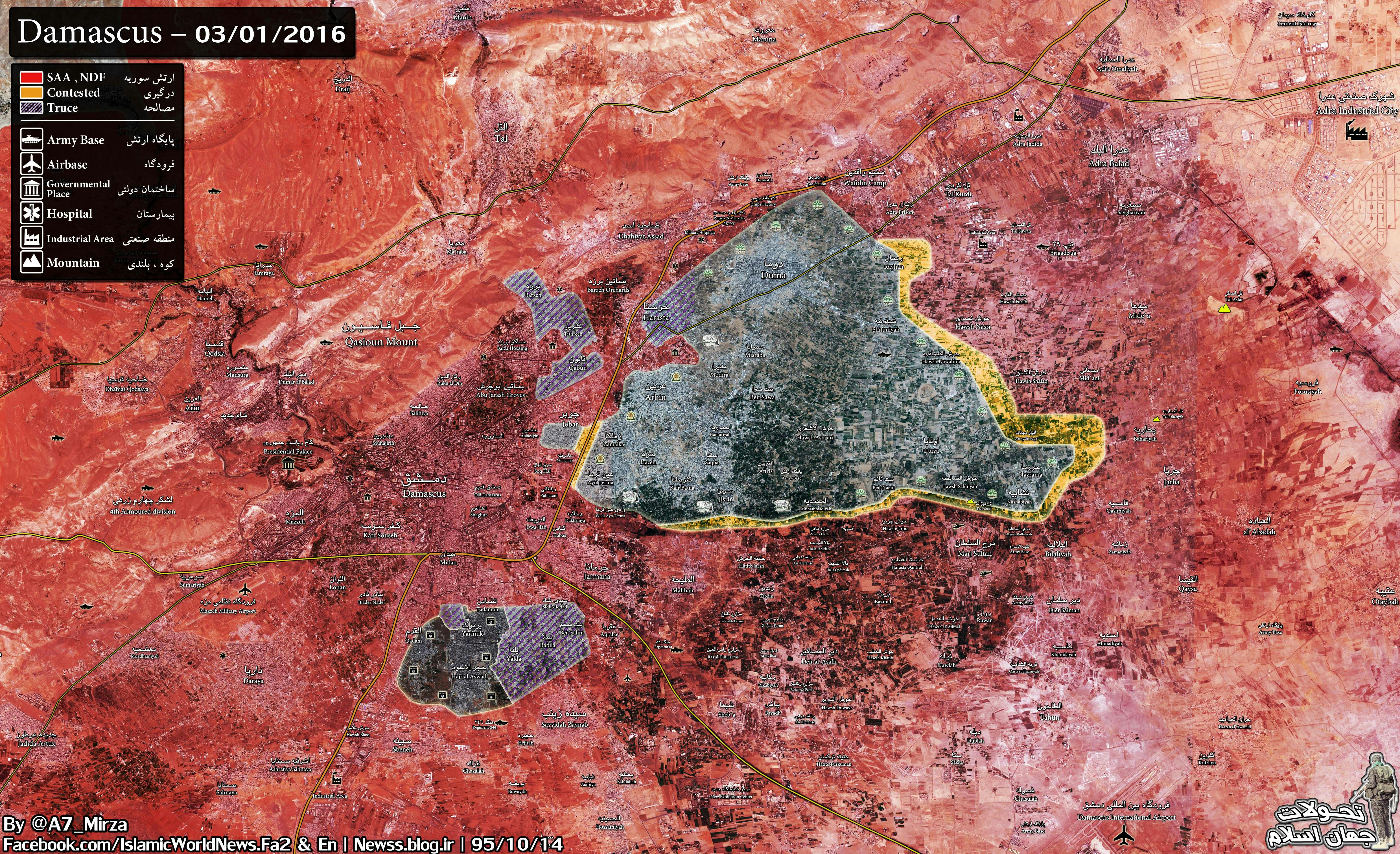
- Mayby the city of Adra is under rebel control and Adra industrial city under army control. Pro gov source confirmed that.source And Abbadeh Qasimiyah Jarba under army conrol: The Daily Star Source say: town of Nashabiyah, in the eastern outskirts of Damascus, near a railway marking the front line between Islamist fighters and Assad’s forces backed by Hezbollah.It makes abadeh jarba and qasimiyah under army control.Railway Hanibal911 (talk) 15:38, 30 May 2014 (UTC)
- I'm not entirely sure if it should be contested (I think there's only clashes on the outskirts, which is already reflected on the map by the proximity of government forces)... But if you think it should be marked contested you're welcome to edit the map yourself. Kami888 (talk) 09:21, 27 February 2014 (UTC)
- Now thanks for you the map reflects the real situation. Only small inaccuracy the city Duma contested. Hanibal911 (talk) 09:15, 27 February 2014 (UTC)
- This area was already marked [1] as contested by MrPenguin20, I didn't change that yet - so all complaints about that to him please. However, I will change it to red since it is red on general map. Kami888 (talk) 09:03, 27 February 2014 (UTC)
![[1]](https://en.wikipedia.org/wiki/File:Rif_Dimashq_offensive_%28September_2013%29.svg)
Aleppo map[edit]
You should probably add to your map the names of those other towns and villages southeast and east of the city that the Army captured. EkoGraf (talk) 13:47, 8 March 2014 (UTC)
- I've labeled the most important ones like Tall Aran, Tall Shughayb, and al Naqqirin. If I label every tiny village the map will probably be very cluttered. Kami888 (talk) 20:08, 8 March 2014 (UTC)
The regime has gained control of the Hanano neighborhood.Al Monitor Hanibal911 (talk) 10:57, 9 March 2014 (UTC)
- With all due respect for al Monitor, this pretty much has to be a mistake on the author's part. The army has barely entered Hanano and it's a huge district that is also a rebel stronghold. It's not realistic for it to have fallen in its entirety. The same article makes other strange claims, for example "In parallel, army units would advance from al-Lermoun toward Beni Zeid". On our map this makes little sense since al-Lermoun is contested and Beni Zeid is mostly government controlled. I suggest we wait for other sources to confirm this "major development", but if you like you can edit the map yourself. Kami888 (talk) 17:59, 9 March 2014 (UTC)
On our map this makes little sense since al-Lermoun is contested and Beni Zeid is mostly government controlled. Actually it does make sense. Because, although the Army is mostly in control of Beni Zeid, the northern part of the district, which is right across from al-Lermoun, is still contested. And if they want to impose a blockade around the city as they say, they would want to link up all of those outer districts. As for Hanano, I would suggest for you to break it down into three parts. Color the western part of Hanano as rebel-held, the central part of it as contested and the eastern part (the most outlying one) as government-held. Fair enough? EkoGraf (talk) 21:46, 9 March 2014 (UTC)
- I suppose that may work, though even that would probably be way over optimistic on the loyalist side. But please direct all requests for Aleppo map to its own talk page [2]. I don't want to be solely held responsible for maintaining it lol. Kami888 (talk) 22:21, 9 March 2014 (UTC)
- Any future changes I will request at the map's talk page. But back to the discussion at hand, the proposed compromise change should be made, regardless if its optimistic or not on the loyalist side or wether it was a mistake on the author's part when writing it into his article. Because ours is to edit per the sources at hand, not to speculate. In any case, I to am of the opinion that the whole district most certainly has not been conquered by the Army, but part of it maybe. So I think my compromise proposal is appropriate. Thank you in advance! Cheers! EkoGraf (talk) 01:41, 10 March 2014 (UTC)
- Fighting raged in the Bustan al-Qasr neighborhood.The Daily Star Hanibal911 (talk) 08:29, 14 March 2014 (UTC)
- I think we can trust this information because its authenticity confirmed in reliable source. Hanibal911 (talk) 16:58, 17 March 2014 (UTC)
- Sorry I haven't noticed this.. Once again can you please make these requests on the map's own talk page? As with regards to Bustan al Qasr, I guess the northern edge should be made olive? I don't know how much of it is contested but from what I understand not a lot, because the crossing between government-controlled and rebel-controlled territory is at the northern edge. Kami888 (talk) 18:22, 17 March 2014 (UTC)
- I think we can trust this information because its authenticity confirmed in reliable source. Hanibal911 (talk) 16:58, 17 March 2014 (UTC)
- Fighting raged in the Bustan al-Qasr neighborhood.The Daily Star Hanibal911 (talk) 08:29, 14 March 2014 (UTC)
- Any future changes I will request at the map's talk page. But back to the discussion at hand, the proposed compromise change should be made, regardless if its optimistic or not on the loyalist side or wether it was a mistake on the author's part when writing it into his article. Because ours is to edit per the sources at hand, not to speculate. In any case, I to am of the opinion that the whole district most certainly has not been conquered by the Army, but part of it maybe. So I think my compromise proposal is appropriate. Thank you in advance! Cheers! EkoGraf (talk) 01:41, 10 March 2014 (UTC)
![[2]](https://en.wikipedia.org/wiki/File_talk:Rif_Aleppo2.svg)
SOHR says that regime forces and its allied have taken over the AL-Ma'amel area and SOHR says the regular forces regained control of the areas of the bathroom and the village of Aziza after violent clashes with Nusra Front fighters and several Islamic battalions. Here on this Map shows where AL-Ma'amel area. Hanibal911 (talk) 10:36, 27 March 2014 (UTC)
This the map from the pro opposition source displays the army advances in the north of Aleppo and shows that the army captured the territory east of Sheik Najar industrial zone as well as army moving towards Aleppo prison. Hanibal911 (talk) 09:19, 4 May 2014 (UTC)
Army launched a major offensive in Aleppo. The Syrian army broke siege of the central prison of the city Aleppo. Also troops blocked all supply channels rebels in the eastern part of Aleppo.Arab Chronicle Also Hezbollah, Syrian troops and Iraq'i shia militias advancing toward Owaija, north to Aleppo, closer to the main northern access. This confirms the pro opposition source.Arab ChronicleArab Chronicle Hanibal911 (talk) 19:38, 4 May 2014 (UTC)
- On the west, the rebels made a push last week to capture the city’s military academy, the major government-held installation in the city’s western quadrant. But attack, however, ended in catastrophe, exposing the rebels to repeated attacks from the air, even at night, that made it impossible to move men and weapons freely. Also government already controls, the industrial zone and the all Haydariyeh district in the city’s northeast. Ledger-EnquirerCharlotte ObserverThe TelegraphSun HeraldVC StarMcClatchly DCIdaho StatesmanMiami Herald Also the same source states that Haidariah is government controlled. The area where fighting is going mentioned in the source on is likely to be that between Hanano and Owaja.here Because reliable source said that government already controls, the industrial zone and the al Haidariah district in the city’s northeast but rebels are battling to keep government forces from taking the area between two zones which the government already controls.sourcesource The pro opposition source Ara News reports that SAA control part of Kalasseh neighborood, that is shown full green in the map. It must become at least partially red. This info fits with the map that provides a picture quite different from the one from this map. This map also noted that not all the Bustan al Qasr neighborood under control by rebels. But SOHR Also said that clashes took place between the two sides in Bustan al-Qasr.SOHR Hanibal911 (talk) 14:17, 14 August 2014 (UTC)
Ramousah, Jdeydeh and Ashrafiyeh[edit]
Per a new pro-opposition map [3] Ramousah and Jdeydeh districts are firmly in government hands, please change them to red. Also, here is one more map [4], based on opposition sources, per which Ramousah and Jdeydeh are government-held, as well as Ashrafiyeh. So please change Ashrafiyeh to red too please. EkoGraf (talk) 10:59, 24 March 2014 (UTC)
- Syrian troops control the Ashrafiyeh district.Al Jazeera Hanibal911 (talk) 19:31, 5 May 2014 (UTC)
Rif Dimashq Map[edit]
Yarmuk should be marked as under a ceasefire again. Ceasefire has been confirmed today [5]. EkoGraf (talk) 11:57, 31 March 2014 (UTC)
- On this map, the city of Duma must noted as a besieged of the government troops this confirms Al Jazeera. Hanibal911 (talk) 06:02, 30 May 2014 (UTC)
Shammar[edit]
Per SOHR [6] the Army captured the village of Shammar, east of Aleppo [7]. So you need to appropriately push government-held territory (red) a bit to the east to encompase the village. EkoGraf (talk) 15:28, 27 April 2014 (UTC)
Syrian troops seized the towns of Al Madyunah and Soran after ISIS withdraw from the towns without clashes per Hawar News. So to summ it up. Government-held territory needs to be extended east to include Shammar, Al Madyunah and Soran. EkoGraf (talk) 18:48, 1 May 2014 (UTC)
- That confirmation from pro opposition source that the army advances in the eastern part of Aleppo.Arab Chronicle Hanibal911 (talk) 18:04, 3 May 2014 (UTC)
Mliha[edit]
Mliha in the Damascus countryside has been captured [8] by the Army. Change to red please. EkoGraf (talk) 21:05, 3 May 2014 (UTC)
Non-twitter sources provided at map talk page, although the twitter account belongs to a reliable news correspondent so that too should have sufficed. EkoGraf (talk) 03:09, 4 May 2014 (UTC)
- Pro opposition source confirmed that Syrian regime forces have recaptured of town al-Mleiha.source Hanibal911 (talk) 22:38, 11 August 2014 (UTC)
Aleppo map[edit]
Paolowalter provided a link at the map talk page, but I wanted to leave you a message here also. A new AC map [9] shows large parts of Sheick Najar under SAA control (except the northern half of Sector 2). The town next to the prison Jbeileh is also under SAA control. Don't know what's happening in Sector 3 of the industrial zone, its off the map. EkoGraf (talk) 12:25, 25 May 2014 (UTC)
- Clashes took place between the two sides in Bustan al-Qasr. SOHR And also please update this map on based of this map Hanibal911 (talk) 10:42, 20 July 2014 (UTC)
- Pro opposition source said that rebels of al-Mujahideen Army targeted military bases of the pro-Assad forces in Kallaseh neighbourhood in the city of Aleppo, using heavy artillery. al-Mujahideen Army fighters targeted gatherings of the pro-regime forces in the Fire Department in Kallaseh neighbourhood.source Hanibal911 (talk) 10:56, 20 July 2014 (UTC)
- Hanibal911 - That map, who is its source, is it reputable, unbiased? As you know, if it isn't then it won't be enough to update this. I notice some rather strange things about it, for example, it shows the Ummayyad mosque as government held, which defies all other information we have about it. Kami888 (talk) 19:09, 20 July 2014 (UTC)
- Syrian troops take control the hill of Khan Toman.SOHR Hanibal911 (talk) 12:21, 18 August 2014 (UTC)
- Hanibal911 - That map, who is its source, is it reputable, unbiased? As you know, if it isn't then it won't be enough to update this. I notice some rather strange things about it, for example, it shows the Ummayyad mosque as government held, which defies all other information we have about it. Kami888 (talk) 19:09, 20 July 2014 (UTC)
- Pro opposition source said that rebels of al-Mujahideen Army targeted military bases of the pro-Assad forces in Kallaseh neighbourhood in the city of Aleppo, using heavy artillery. al-Mujahideen Army fighters targeted gatherings of the pro-regime forces in the Fire Department in Kallaseh neighbourhood.source Hanibal911 (talk) 10:56, 20 July 2014 (UTC)
Moadamyeh[edit]
The city of Moadamyeh under control of the syrian troops but the rebels fled the city and located on its the outskirts. Source said that the residential area at the other end of the border is Moadamiya, a Damascus suburb where reconciliation was reached a few weeks ago and gunmen are still around.Al Monitor Hanibal911 (talk) 17:19, 31 May 2014 (UTC)
- That's... not what that sentence means. "Around" means inside the city. Anyway, thanks for the article. Kami888 (talk) 08:02, 1 June 2014 (UTC)
- You are wrong because the source is clearly stated that the rebels located around the city but not in the city. So I think it necessary correct the map. "Read: The residential area at the other end of the border is Moadamiya, a Damascus suburb where reconciliation was reached a few weeks ago and gunmen are still around. It is true that security is prevailing here, and is maintained by this long series of checkpoints and inspections and the hassle of waiting under the sun."Al Monitor Hanibal911 (talk) 08:40, 1 June 2014 (UTC)
Also the city of Duma must noted as a besieged of the government troops this confirms Al Jazeera. Hanibal911 (talk) 08:41, 1 June 2014 (UTC)
- It is already marked as besieged, along with entire East Ghouta. Kami888 (talk) 19:26, 1 June 2014 (UTC)
Mid’a[edit]
Mid’a in Easte Ghouta has been reported for days by SOHR to be in the midst of fighting between rebels and ISIS [11]. A new color for their clashes in that area should be added. EkoGraf (talk) 14:03, 2 July 2014 (UTC)
Never mind, SOHR has reported the rebels pushed them out. EkoGraf (talk) 15:27, 3 July 2014 (UTC)
Aleppo industrial city[edit]
Pro-government Syria perspective, and now pro-opposition Syria direct (3 July news report) have reported that the Army has captured large swathes of the industrial city, especially industrial area 3. It also reported the Army is now advancing to capture the rest of the industrial zone. You have already marked Area 1 as army-held and Areas 2 and 3 as contested. I think you should mark Area 2 and the lower half of Area 3 as army-held and the upper half of Area 3 as contested. EkoGraf (talk) 15:34, 3 July 2014 (UTC)
Confirmed by SOHR now as well. EkoGraf (talk) 17:21, 3 July 2014 (UTC)
- Here the source SOHR Hanibal911 (talk) 17:27, 3 July 2014 (UTC)
- Another source confirming the capture of the whole industrial zone [12]. EkoGraf (talk) 01:00, 4 July 2014 (UTC)
- The regime forces and their militiamen took control over the two villages of Kafr Saghir and Al Rahmaneyya which is located northeast of the Industrial City in Al Shek Najjar. While violent clashes have taken place between the same parties in the village of Al Ma’badeyya near the village of Al Moqbela.SOHR Please update the map! Also here video reports from the industrial city which shows that city fully under army control. here and here also here confirmation from the pro opposition source Cedric Labrousse Hanibal911 (talk) 17:28, 4 July 2014 (UTC)
- Another source confirming the capture of the whole industrial zone [12]. EkoGraf (talk) 01:00, 4 July 2014 (UTC)
The Army has captured Al Naseryyi [13], near Tall Shair, and is advancing towards the infantry school now, also the Army has come within artillery range of Halisah and Fafin. You should double-check the translation of the names before making the changes though. EkoGraf (talk) 21:55, 4 July 2014 (UTC)
- The Army also captured the village of Moqbila, just north of Aleppo, tightening their grip on the city's entrances. Syrian army already control much of western Aleppo and have closed down most of the city's southern entrances.And troops now control a main highway north of Aleppo and army had closed a belt of up to 80 percent from the north.NDTV NewsABC News Hanibal911 (talk) 11:50, 8 July 2014 (UTC)
- Special Forces of the Republican Guard and Hezbollah arrived to Aleppo, where the regime forces have tried to besiege the city and take control over Handarat camp in order to cut the supply lines from the rebel and islamic battalions in the northern and eastern neighborhoods of Aleppo.SOHR Hanibal911 (talk) 12:33, 9 July 2014 (UTC)
- Also regime troops were now attacking the Infantry SchoolUniversity Training Center, an army base to the direct north of the city whose capture 18 months ago was a major victory for the opposition.The Telegraph Hanibal911 (talk) 13:25, 9 July 2014 (UTC)
- Special Forces of the Republican Guard and Hezbollah arrived to Aleppo, where the regime forces have tried to besiege the city and take control over Handarat camp in order to cut the supply lines from the rebel and islamic battalions in the northern and eastern neighborhoods of Aleppo.SOHR Hanibal911 (talk) 12:33, 9 July 2014 (UTC)
Mayda'a in Ghuta[edit]
- The city of Maydaa under army control here confirmation from a reliable source.Reuters On the map taken from a reliable source specified that the city under the control of the army. Please update your map. Hanibal911 (talk) 07:30, 7 July 2014 (UTC)
- I changed it but someone reverted the edit. He said he left a comment on the talk page but I don't see one. Weird. Kami888 (talk) 16:38, 8 July 2014 (UTC)
- Editor Joan301009 without any data update the map you can fix it. You can return the previous version and update it in accordance with the data on the talk page. Hanibal911 (talk) 18:29, 7 July 2014 (UTC)
Maliha[edit]
SAA has taken full control of Maliha [14], rebels still putting up resistance in its northern outskirts. Please put the town red and its northern outskirts contested. EkoGraf (talk) 12:28, 14 August 2014 (UTC)
- Sohr also said that the violent clashes between the rebel and Islamic battalions and the Nusra Front against the regime forces supported by fighters of NSD and Hezbollah have still taking place on the outskirts of the town of Al Mleha in the Eastern Ghota. But the regime forces supported by NDF and Hezbollah fighters took control over the whole of Al Mleha Town after violent clashes lasted for months.SOHR Hanibal911 (talk) 14:52, 14 August 2014 (UTC)
- Syrian troops regained control the town of Al Maliha.NaharnetLos Angeles TimesGulf TimesAFPSOHRNDTVThe Sacramento BeeMSN News Hanibal911 (talk) 07:50, 16 August 2014 (UTC)
Haydariya district[edit]
The same source states that Haydariya is government controlled. The area where fighting is going mentioned in the source on is likely to be that between Hanano and Owaja (See map http://wikimapia.org/#lang=de&lat=36.252649&lon=37.199879&z=15&m=b&permpoly=105540). Ledger-EnquirerCharlotte ObserverThe TelegraphSun HeraldVC StarMcClatchly DCIdaho StatesmanMiami Herald So that you can update the map. Because this data also was confirmed by the rebels! Hanibal911 (talk) 08:02, 16 August 2014 (UTC)
Khan Toman[edit]
Army has captured Khan Toman hill [15]. Please update. Thanks! EkoGraf (talk) 14:36, 18 August 2014 (UTC)
- In reply to your question. The village IS the hill Khan Tuman. EkoGraf (talk) 04:14, 19 August 2014 (UTC)
Qudsaya[edit]
Qudsaya in Rif Dimashq under control by Syrian troops and no rebel fighters in this area.Al Monitor Hanibal911 (talk) 08:44, 15 September 2014 (UTC)
Adra[edit]
Source clear said that the army had taken control of an area in the town used to house workers, after securing the highway and the industrial zone. He acknowledged, however, that Adra’s small Old City remained under rebel control. Also the field commander said a large number of rebels had withdrawn to the Old City as the army advanced.The Daily Star And here this area Old City Adrahere. So you can update map because at the moment it looks as if by army nothing not recaptured. Hanibal911 (talk) 08:08, 27 September 2014 (UTC)
- Also pro opposition source claimed that all rebels retreated from all area of city Adta in E-Ghouta.Archicivilians Hanibal911 (talk) 08:27, 27 September 2014 (UTC)
- SOHR today reported that the regime army took control over wide areas in Adra al Balad Area after two days of its control over the Labor City of Adra.source So now the whole town of Adra under army control. Hanibal911 (talk) 11:38, 27 September 2014 (UTC)
- Also here pro opposition map dated on 20 September which clear show that Industrial City Adra which located on east from city Adra under control by army. So that our map was right and now after army offensive on the rebels position in city of Adra army take full control of the city Adra. Hanibal911 (talk) 14:04, 27 September 2014 (UTC)
- SOHR today reported that the regime army took control over wide areas in Adra al Balad Area after two days of its control over the Labor City of Adra.source So now the whole town of Adra under army control. Hanibal911 (talk) 11:38, 27 September 2014 (UTC)
Hi please add new changes in Rif Dameshqe map the whole Adra is Under the control of SAA.151.238.155.124 (talk) 16:19, 27 September 2014 (UTC)
Siege of Kobane[edit]
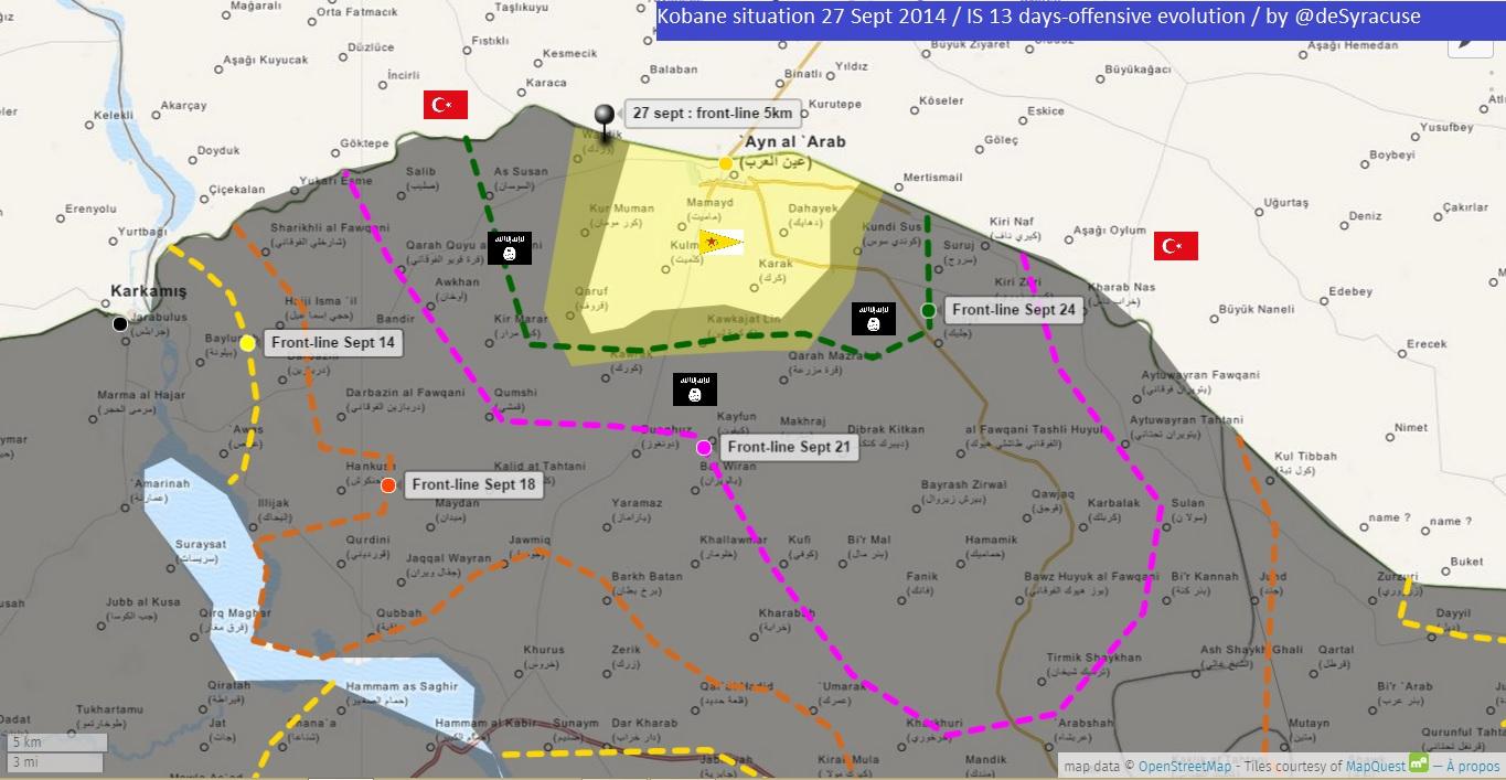
You can update this map.Siege of Kobane What would this map showed the current situation in this area in accordance with the data of the map.Syrian Civil War detailed map Hanibal911 (talk) 21:08, 26 September 2014 (UTC)
You got a nice source here [16]. EkoGraf (talk) 19:25, 28 September 2014 (UTC)
- Here new map from BBC which show situation around city Kobane.source Map from BBC confirmed the data on this map dated on 27 September from the deSyracuse. Hanibal911 (talk) 09:41, 30 September 2014 (UTC)
Rif Dimashq map[edit]
Sources (including SOHR) [17][18] say the Syrian army recaptured Dukhaniyya here [19]. EkoGraf (talk) 15:35, 28 September 2014 (UTC)
- Kurdish journalist reporting SAA has captured Al-Suwan and are fighting for Tal-al-Kurdy as they advance towards Duma. Source [20]. EkoGraf (talk) 12:34, 29 September 2014 (UTC)
- Pro-government source [21] also reporting Al-Suwan (Tal al-Sawwan) captured. Location somewhere here [22]. EkoGraf (talk) 14:07, 29 September 2014 (UTC)
- SOHR reported that clashes regime forces against Islamic battalions in the city Irbin.source Hanibal911 (talk) 10:41, 4 October 2014 (UTC)
- SOHR has confirmed the SAA capture of Ein Terma valley [23]. Location here [24]. EkoGraf (talk) 03:42, 13 October 2014 (UTC)
- Pro opposition source confirmed that Government troops seized Bala farms further East completing Zebdeen encirclement. Hanibal911 (talk) 20:58, 8 November 2014 (UTC)
- SOHR has confirmed the SAA capture of Ein Terma valley [23]. Location here [24]. EkoGraf (talk) 03:42, 13 October 2014 (UTC)
- SOHR reported that clashes regime forces against Islamic battalions in the city Irbin.source Hanibal911 (talk) 10:41, 4 October 2014 (UTC)
- Pro-government source [21] also reporting Al-Suwan (Tal al-Sawwan) captured. Location somewhere here [22]. EkoGraf (talk) 14:07, 29 September 2014 (UTC)
- The Southern Bypass Highway which passes eastern from Jodar and near Zamalka in East Damascus now noted as contested here but pro government map and and earlier it this highway also was marked under control by army on some pro-opposition maps.11 September20 September16 October20 October8 November10 November So we need correct this. Hanibal911 (talk) 13:41, 28 November 2014 (UTC)
- You can update map! Acoording to pro opposition source here Syrian army recaptured area to south of Harasta wher located Army Armored Vehicle Base (Irbeen) in the northern part of the city Irbeen. And recaptured part of Qaboun area. Also Southern Bypass Highway under control by army. And city Al Taybeh in the west of Rif Dimashq neem noted as contested.SOHR Hanibal911 (talk) 16:38, 2 December 2014 (UTC)
Rif Aleppo map[edit]
The regime forces took control over the village Handarat and hill of Tall Handarat and cut off the supply lines of the rebels- held areas in the city of Aleppo by monitoring the Kastillo road and al Jandul roundabout.SOHRReuters Hanibal911 (talk) 15:09, 3 October 2014 (UTC)
- Also army captured village al-Mudafah and Sifat, including four intersections west of Sifat.Reuters Hanibal911 (talk) 15:29, 3 October 2014 (UTC)
- For reference to find the location of the village, which is not the same as the Handarat city district (a bit to the south of it), you can use this map [25]. EkoGraf (talk) 16:18, 3 October 2014 (UTC)
- Pro opposition source reported that clashes were ongoing in the villages of Duwayr az ZaytunDuwayr az Zaytun on Wikimapiasource Hanibal911 (talk) 17:04, 3 October 2014 (UTC)
- Rebel video [26] allegedly showing SAA soldiers withdrawing from El-Mallah which is even further west from Handarat village [27].
- So to summarize: Handarat village, al-Mudafah and Sifat government-held; Duwayr az Zaytun, four-way intersection and eastern edge of El-Mallah contested. EkoGraf (talk) 23:22, 3 October 2014 (UTC)
- The Syrian army has taken control of three villages north from the city Aleppo.The Daily Star Hanibal911 (talk) 10:16, 4 October 2014 (UTC)
- SOHR reported that the regime forces supported by allies took control the village of al Jbayleh and the cement plant in north of the Central Prison of Aleppo.here Hanibal911 (talk) 08:34, 19 October 2014 (UTC)
- The Syrian army has taken control of three villages north from the city Aleppo.The Daily Star Hanibal911 (talk) 10:16, 4 October 2014 (UTC)
- So to summarize: Handarat village, al-Mudafah and Sifat government-held; Duwayr az Zaytun, four-way intersection and eastern edge of El-Mallah contested. EkoGraf (talk) 23:22, 3 October 2014 (UTC)
- Rebel video [26] allegedly showing SAA soldiers withdrawing from El-Mallah which is even further west from Handarat village [27].
- Pro opposition source confirmed that army on 4 November captured Al-Ameria area Hanibal911 (talk) 20:40, 8 November 2014 (UTC)
- You can update a map? Also SOHR said that Jam'ia al-Zahraa neighborhood under control by regime forces.here Hanibal911 (talk) 11:59, 13 November 2014 (UTC)
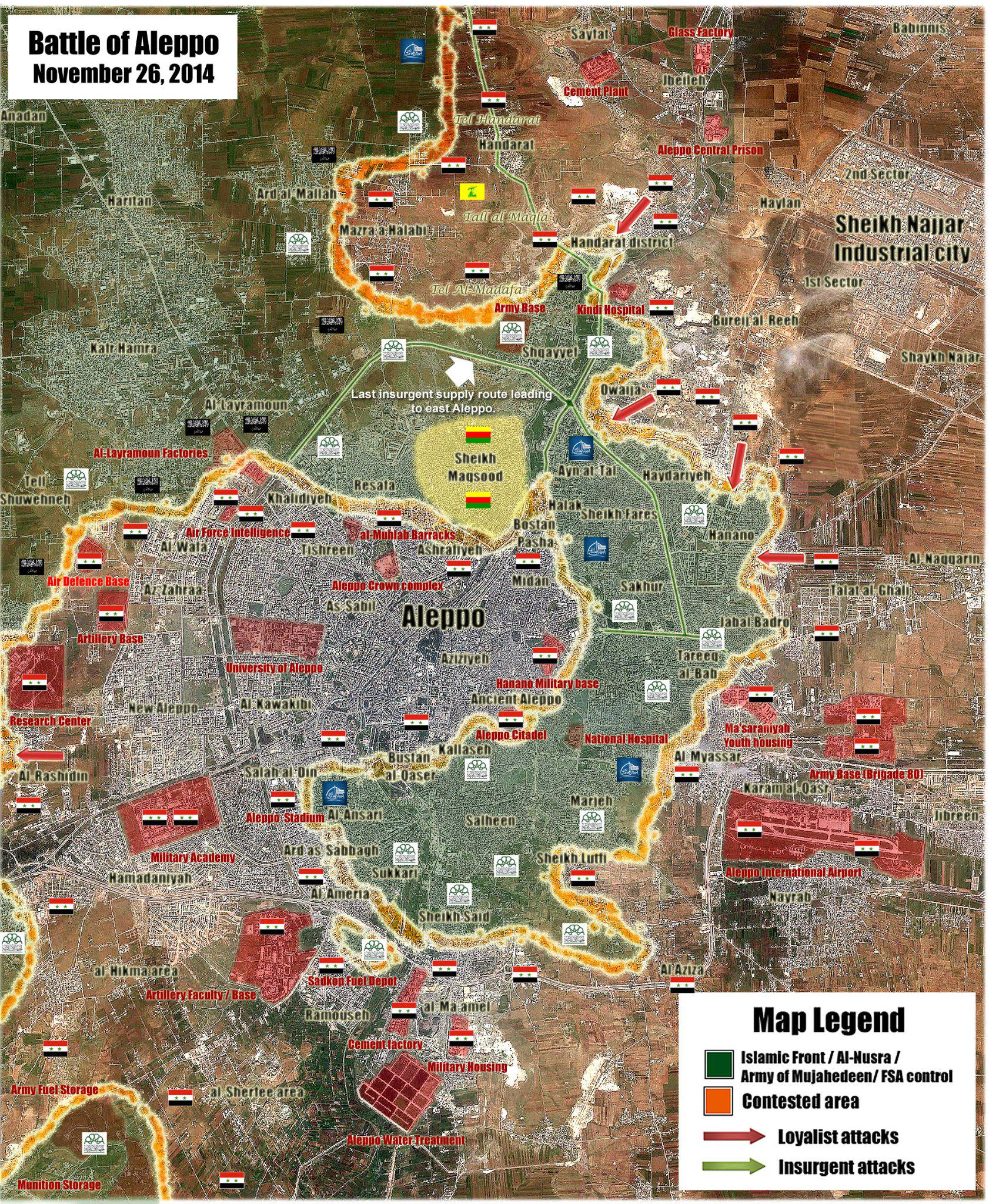
- Turkish military source told that the forces loyal to President Bashar al-Assad are tightening the vice on Aleppo, but leaving a path to the exit path of nearly 5 kilometers in width in the northwestern part of the city.” The main road in and out of Aleppo toward the Turkish border city of Kilis, only 60 kilometers away, passes through this northwestern part of the city.Hurriyet Daily News Hanibal911 (talk) 16:43, 21 November 2014 (UTC)
- On the map this is area where located ammunition storage and army base need noted under control the rebels. This confirm a pro government source.This confirm a pro government source here and pro opposition sourcehere Hanibal911 (talk) 13:50, 28 November 2014 (UTC)
- Turkish military source told that the forces loyal to President Bashar al-Assad are tightening the vice on Aleppo, but leaving a path to the exit path of nearly 5 kilometers in width in the northwestern part of the city.” The main road in and out of Aleppo toward the Turkish border city of Kilis, only 60 kilometers away, passes through this northwestern part of the city.Hurriyet Daily News Hanibal911 (talk) 16:43, 21 November 2014 (UTC)
- You can update a map? Also SOHR said that Jam'ia al-Zahraa neighborhood under control by regime forces.here Hanibal911 (talk) 11:59, 13 November 2014 (UTC)
![[25]](https://pbs.twimg.com/media/BzCAKziCYAMNYwc.jpg:large)
"darkslategray" too close to "black", thus not an acceptible colour[edit]
I notice that you suggested changing the medium grey icon for al-Nusra to "darkslategray" because you said "light grey" hurts your eyes. Since then I found no discussion to support your arbitrary change to the medium grey consensus.
Besides white being much lighter and seemingly more likely to "hurt your eyes",
"darkslategray" displays as slightly darker than dark grey, and the "black" of daesh/ISIS displays as very dark grey since it is surrounded by white on the map. For smaller dots, the 2 colours are almost indistinguishable on an average monitor.
If you have a suggestion for an alternate colour, suggest you discuss and obtain a consensus first.
Note that the most important factor is that the colours be easily distinguishable. "darkslategray" clearly fails the test, so is not an acceptable colour. André437 (talk) 22:57, 11 November 2014 (UTC)
SAA captures al-Breij district in Aleppo[edit]
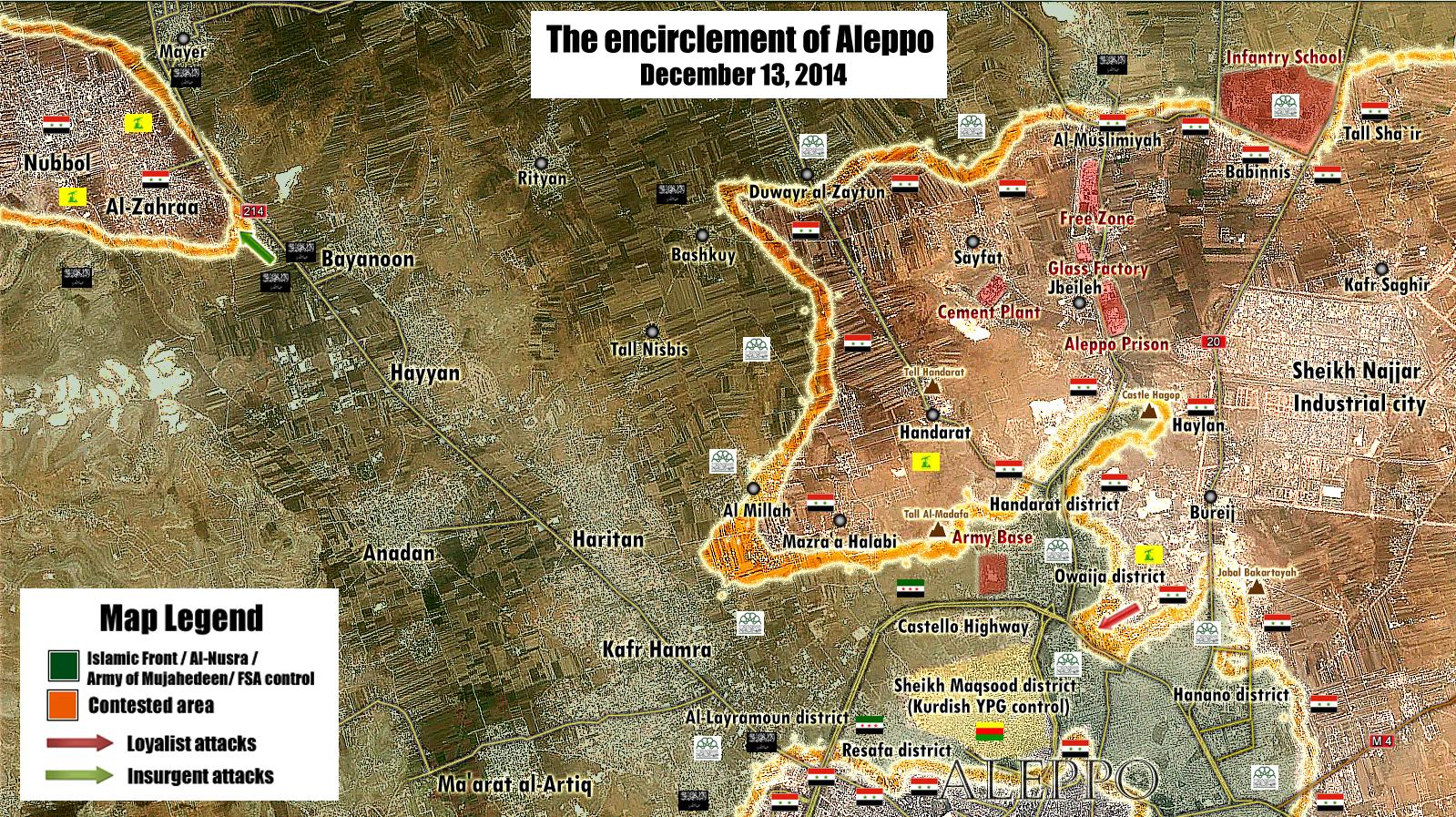
Its been confirmed now by SOHR. The SAA has captured the whole al-Brej area [30]. Location [31]. So please turn it to SAA-held. But leave a thin contested frontline between it and Tall Asfar hill (bit to the southwest) because SOHR is still reporting fighting there. EkoGraf (talk) 17:51, 13 December 2014 (UTC)
You can also use as a reference this semi-pro-government map [32]. EkoGraf (talk) 00:17, 14 December 2014 (UTC)
- Syrian troops backed NDF and Hezbollah entered Mazare'al-Mallah in direction of Castello. Here confirmation from reliable sourceElijah J. Magnier and government sourcehere Hanibal911 (talk) 09:05, 14 December 2014 (UTC)
- South and West of Handarat are under control Syrian troops and now the of Castello road under fire Syrian troops and input and any rebels supply line closed.Elijah J. Magnier Also here data from a pro opposition source about the importance of Ard al-Mallah/Mazra'a Halabi area.here Hanibal911 (talk) 12:38, 14 December 2014 (UTC)
- Syrian troops entering to the Handarart camp and with is now engaged a rebels. This is the most decisive battle for the Syrian troops in Aleppo.here Hanibal911 (talk) 13:41, 14 December 2014 (UTC)
- South and West of Handarat are under control Syrian troops and now the of Castello road under fire Syrian troops and input and any rebels supply line closed.Elijah J. Magnier Also here data from a pro opposition source about the importance of Ard al-Mallah/Mazra'a Halabi area.here Hanibal911 (talk) 12:38, 14 December 2014 (UTC)
SAA advances in Handarat and al-Mallah[edit]
A pro-government source [33] reported the SAA captured the al-Mallah area here [34] while SOHR [35] and neutral Elijah J.Magnier [36] reported the SAA advanced into it. So at the very least it should be marked as contested while the Mazra'a Halabi area to the east of it should be marked as SAA-held. Further credence to the capture of Mazra'a Halabi can be found in today's report [37] that the area east of al-Mallah has been captured by the SAA. Also, neutral source Elijah J.Magnier [38] reported the SAA captured the south and west of the Handarat city district. Please make these updates along with the earlier SOHR confirmation of the capture of the Breij area. Thank you! EkoGraf (talk) 15:46, 14 December 2014 (UTC)
SOHR confirmed [39], SAA has captured al-Mallah and are attempting to advance further west. EkoGraf (talk) 17:47, 14 December 2014 (UTC)
Pro-opposition map [40] further confirming the SAA capture of Breij and al-Mallah, as well as part of Owaija. Also, it confirms that all of Salahadine and Saif al-Dawla districts, except for the lower right corner (contested), are SAA-held. Please make all of these corrections. Thank you! EkoGraf (talk) 02:43, 15 December 2014 (UTC)
![[40]](http://www.agathocledesyracuse.com/wp-content/uploads/2014/12/Aleppo-14-Dec-2014-by-@deSyracuse.png)
Just wanted to thank you for your recent edit. But now, I need to ask for a new edit since a new development has arisen today. :) Pro-opposition SOHR confirmed [41] the SAA recaptured Aghob hill and the al-Fawaz area of al-Brej. Its that bulge in SAA lines here [42]. Also, I noticed you didn't made the change for Salahadine and Saif al-Dawla districts I pointed out earlier per that map. Thanks in advance once again! EkoGraf (talk) 15:07, 17 December 2014 (UTC)
Syria Map editing[edit]
Just wanted to find out, is there a way to edit/update and upload a map by myself ? I mean maps that already exist (Alepo, Daraa etc). DuckZz (talk) 22:08, 6 January 2015 (UTC)
Khan al-Asal[edit]
Pro opposition source reported that clasheh between Syrian army and moderate rebels(FSA) in Khan al-Asal.here Hanibal911 (talk) 12:16, 18 February 2015 (UTC)
2015 Moscow Victory Day Parade---Map of countries[edit]
President of the Republic of Belarus did not participate in this year's parade 2015 in Moscow ″File:BlankMap-World6.svg″ Pls Fix it.
Hi,
You appear to be eligible to vote in the current Arbitration Committee election. The Arbitration Committee is the panel of editors responsible for conducting the Wikipedia arbitration process. It has the authority to enact binding solutions for disputes between editors, primarily related to serious behavioural issues that the community has been unable to resolve. This includes the ability to impose site bans, topic bans, editing restrictions, and other measures needed to maintain our editing environment. The arbitration policy describes the Committee's roles and responsibilities in greater detail. If you wish to participate, you are welcome to review the candidates' statements and submit your choices on the voting page. For the Election committee, MediaWiki message delivery (talk) 16:05, 23 November 2015 (UTC)
Please update Rif Damashq map[edit]
Hello. Can you please update the Rif Dimashq offensive map File:Rif Damashq.svg? Darayya has been caotured by tge Syrian Army after rebels agreed to surrender it:[43], [44] and [45]. Please update it. Thank you. Newsboy39 (talk) 17:26, 28 August 2016 (UTC)
Please update Rif Dimashq offensive map again[edit]
Muadamiyat al-Sham has surrendered to Syrian government as well: [46], [47]. Can you update the Rif Dimashq map to show it under control of the government? Thank you Newsboy39 (talk) 03:31, 2 September 2016 (UTC)
- "Implementation of the agreement is expected to begin on Friday." Let's wait. Kami888 (talk) 04:05, 2 September 2016 (UTC)
Can you please update Rif Dimashq offensive map?[edit]
SAA have captured al-Deirkhabiyeh (http://www.syriahr.com/en/?p=52330). It is located in southwest of the map. Please show it under government control. 59.89.42.148 (talk) 18:15, 14 October 2016 (UTC)
Rebels have surrendered Qudsaya and al-Hamah as well (http://www.syriahr.com/en/?p=52269). Please show them under government control as well. 117.214.153.88 (talk) 04:24, 15 October 2016 (UTC)
ArbCom Elections 2016: Voting now open![edit]
Hello, Kami888. Voting in the 2016 Arbitration Committee elections is open from Monday, 00:00, 21 November through Sunday, 23:59, 4 December to all unblocked users who have registered an account before Wednesday, 00:00, 28 October 2016 and have made at least 150 mainspace edits before Sunday, 00:00, 1 November 2016.
The Arbitration Committee is the panel of editors responsible for conducting the Wikipedia arbitration process. It has the authority to impose binding solutions to disputes between editors, primarily for serious conduct disputes the community has been unable to resolve. This includes the authority to impose site bans, topic bans, editing restrictions, and other measures needed to maintain our editing environment. The arbitration policy describes the Committee's roles and responsibilities in greater detail.
If you wish to participate in the 2016 election, please review the candidates' statements and submit your choices on the voting page. MediaWiki message delivery (talk) 22:08, 21 November 2016 (UTC)
The Institute of Physical Education[edit]
The Institute of Physical Education before the offensive was SAA controlled. Why would they share it with the YPG now? Here is a video providing evidence (0:59-1:02 and 1:27-1:35) Beshogur (talk) 16:32, 28 November 2016 (UTC)
- I didn't change that, the institute is south of the YPG-colored zone. I am updating the whole map btw to show areas where YPG is present. Kami888 (talk) 17:59, 28 November 2016 (UTC)
Ayn al-Tal district at Rif Aleppo2.svg[edit]
Ayn Al Tall district conrolled SAA not mixd controll SAA/SDF.link Only parts of Bustan al Basha and Hellok under mixed controll SAA/SDF.linklink Mehmedsons (talk) 08:37, 5 December 2016 (UTC)
- I can change it to how you described it, but I'm not really sure if that's how it is. If we assume the map you cited by the pro-Kurdish guy to be at all reliable, then we should also probably mark Sheikh Fares as contested/shared and the Physical Education Institute in Bustan Pasha as well. The situation in Aleppo is overall very confused right now, once the smoke clears a little bit I'll update. Kami888 (talk) 03:01, 7 December 2016 (UTC)
Sukkari district in Battle of Aleppo map[edit]
Atleast half of the Sukkari district, which is immediately west of the Sheikh Saeed, was captured by Syrian Army. Russian Defence Ministry however stated they captured it completely. Here is a source containing a map by the reliable Jane's Information Group/IHS Jane showing the confirmed advances (http://www.bbc.com/news/world-middle-east-38329461). Please update the map to reflect this. Maybe the other half of Sukkari which is not shown as under control of the Syrian Army, should be shown as contested since Russia said it controls it in full. But it is up to you. At the least please do make the changes per IHS Jane map. Although a withdrawal agreement, has been reached, rebels are yet to be evacuated. Until they are evacuated and government actually takes control, the whole of East Aleppo shouldn't be shown under Army control. 117.199.87.92 (talk) 20:59, 15 December 2016 (UTC)
- This is all going to be irrelevant in less than a day now, I'd prefer just to wait and color it all red afterwards. Kami888 (talk) 05:54, 16 December 2016 (UTC)
- Not really. The evacuation has been suspended again. The Red Cross, stated yesterday that it will take 2 or 3 days for everyone to be evacuated. By my calculation, that's one convoy every hour to hour and a half without any pause. However, this was before evacuation was suspended again. And it is likely the deal might collapse for a third time or completely be scrapped. Therefor, I think it is better to show the Army advance in Sukkari district. 125.62.118.116 (talk) 10:54, 16 December 2016 (UTC)
- The clashes have started again. It is better to make the changes now. 124.253.247.62 (talk) 13:08, 16 December 2016 (UTC)
- I'm ready to make the change since, as you've said, we are seeing delays in the evacuation. However, I'm not going to make any changes based on the IHS Map in the BBC article you linked and I think you know why. If you're not sure, just stare at it for a few minutes and the answer will come to you. If you have any other sources explaining the situation in Sukkari please let me know, or you can make the change yourself if you insist. Kami888 (talk) 08:22, 17 December 2016 (UTC)
- I don't understand, I see nothing wrong in it. It is pretty reliable as it only makes map based on confirmed advances. And it has even been used by the media. Is it because of copyright? Besides I don't know any other map showing the advances. If you don't want to use it, I have an alternative. Why don't we just paint the entire Sukkari as contested? As already said already Russia claimed Syrian Army controlled entirety of it. 59.89.43.70 (talk) 00:20, 18 December 2016 (UTC)
- Where's the link to the russian claim? As for the IHS map, it's just broken. The layover is obviously displaced relative to the background in the north-east direction by a significant margin (about 1.5km). Therefore, none of what the map "shows" is actually accurate. Unless we are looking at different maps here, I can't understand how you couldn't see the same right away. Kami888 (talk) 04:30, 18 December 2016 (UTC)
- Here (http://www.geopolmonitor.com/syrian-army-wards-off-breakthrough-attempt-militants-aleppo/). About your other statement, I don't understand what you are saying. Guess I don't have much knowledge about digital maps. 45.122.145.229 (talk) 15:03, 18 December 2016 (UTC)
- Where's the link to the russian claim? As for the IHS map, it's just broken. The layover is obviously displaced relative to the background in the north-east direction by a significant margin (about 1.5km). Therefore, none of what the map "shows" is actually accurate. Unless we are looking at different maps here, I can't understand how you couldn't see the same right away. Kami888 (talk) 04:30, 18 December 2016 (UTC)
- I don't understand, I see nothing wrong in it. It is pretty reliable as it only makes map based on confirmed advances. And it has even been used by the media. Is it because of copyright? Besides I don't know any other map showing the advances. If you don't want to use it, I have an alternative. Why don't we just paint the entire Sukkari as contested? As already said already Russia claimed Syrian Army controlled entirety of it. 59.89.43.70 (talk) 00:20, 18 December 2016 (UTC)
- I'm ready to make the change since, as you've said, we are seeing delays in the evacuation. However, I'm not going to make any changes based on the IHS Map in the BBC article you linked and I think you know why. If you're not sure, just stare at it for a few minutes and the answer will come to you. If you have any other sources explaining the situation in Sukkari please let me know, or you can make the change yourself if you insist. Kami888 (talk) 08:22, 17 December 2016 (UTC)
- The clashes have started again. It is better to make the changes now. 124.253.247.62 (talk) 13:08, 16 December 2016 (UTC)
- Not really. The evacuation has been suspended again. The Red Cross, stated yesterday that it will take 2 or 3 days for everyone to be evacuated. By my calculation, that's one convoy every hour to hour and a half without any pause. However, this was before evacuation was suspended again. And it is likely the deal might collapse for a third time or completely be scrapped. Therefor, I think it is better to show the Army advance in Sukkari district. 125.62.118.116 (talk) 10:54, 16 December 2016 (UTC)
Raqqa offensive[edit]
Please also update the map of Northern Raqqa offensive. It hasn't been updated since the ending of the first phase. The second pahse is ongoing woth SDF advancing in the western countryside along the western highway to Raqqa. I think you can find some maps as reference online by yourselves. Please do update it. 59.89.43.70 (talk) 01:46, 18 December 2016 (UTC)
- It seems to me like it's updated, I can see the SDF advances which you mentioned. But anyway, if you want something updated, I don't see why you are asking me when you can do it yourself - here's the link: [48]. Enjoy. :) Kami888 (talk) 04:21, 18 December 2016 (UTC)
- I am talking about File:Northern Raqqa Offensive (November 2016).svg. The map hasn't been updated since 25 November. 45.122.145.229 (talk) 15:08, 18 December 2016 (UTC)
- I'am handling the Raqqa map as of now. Kami888, if you want to help where it's the most needed, keep your focus on the Mosul city map so it stays up-to-date along the new Phase 2 of the offensive. Best regards ! Yug (talk) 16:51, 29 December 2016 (UTC)
- Seems user:MrPenguin20 is handling up the Al-bab and Palmyra offensives ! :D
- As I'am handling up the Northern Raqqa one, it seems we are doing well! :D --Yug (talk) 19:09, 30 December 2016 (UTC)
.svg)
File:Rif Aleppo2.svg[edit]
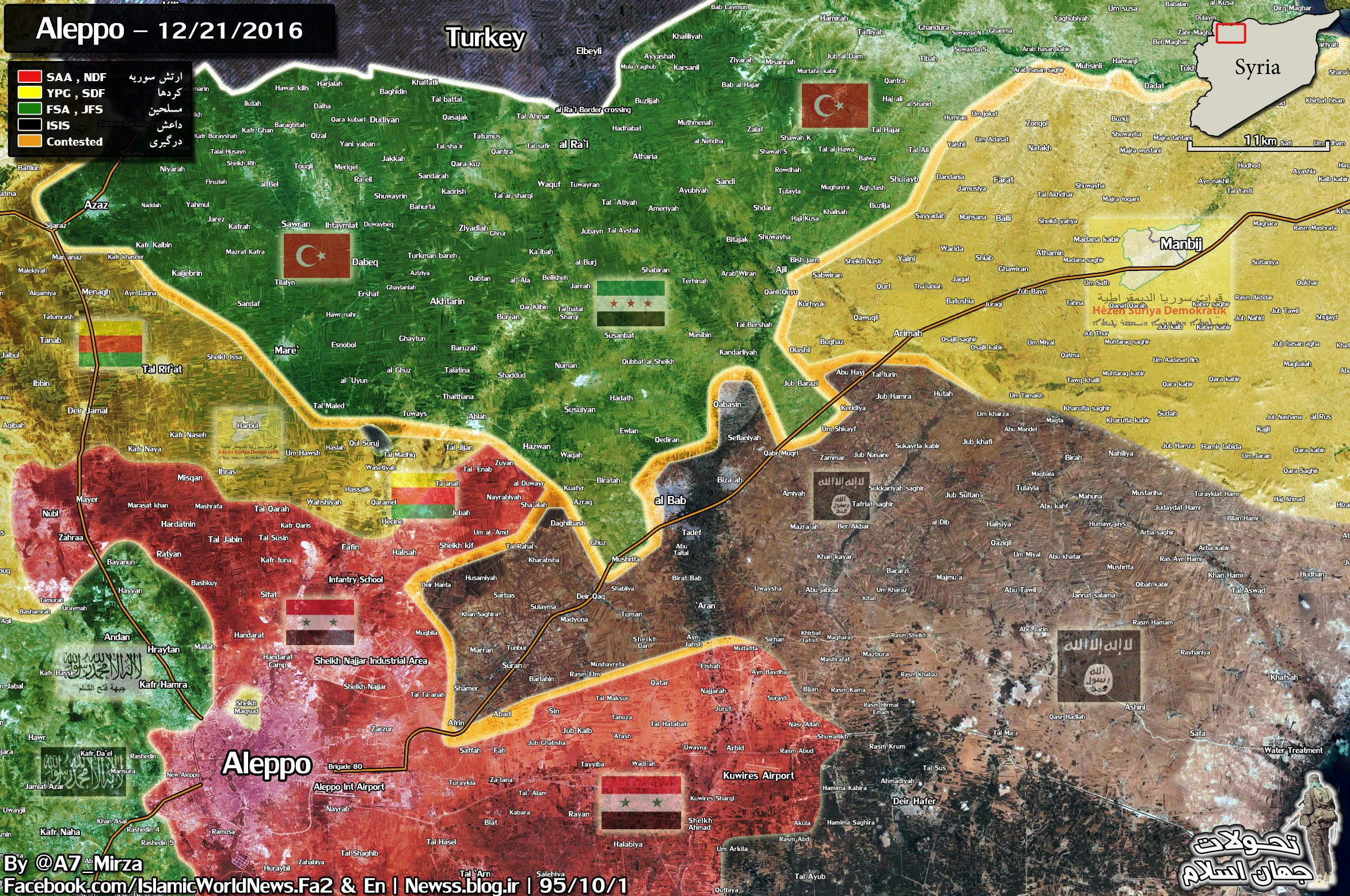
Need make updates as Syrian Army and its allies regain control of the entire city of Aleppo.linklink Mehmedsons (talk) 08:39, 22 December 2016 (UTC)
- Neutral area northeast of Aleppo must be marked as SAA controlled as SDF withdrew from positions shared around Military College. SAA controlling alone all the area including Babinnis, Military college and Tal Shair and SDF withdrew from Al Bab frontline. No more SDF in Jubah(Cobe) and Kashkeshshat. Only SAA. Last YPG, Shahba Women are in Xirbet Diwar, Narbiyah and Ta'anah.linklinklinklinklinklink Mehmedsons (talk) 16:24, 23 December 2016 (UTC)
- Like this:link Mehmedsons (talk) 16:30, 23 December 2016 (UTC)
- This is a rather contentious subject - I've had to change the Aleppo map in that area more than once now back and forth to my embarrassment. I'll do this - I'll wait another day or so to see if the changes made to the general map stick around or someone reverts them. If they stick, I'll make the change to the Aleppo vector map as well. Kami888 (talk) 03:40, 24 December 2016 (UTC)
File:Rif Damashq.svg[edit]
Need make updates at map. Pro govrnment map and pro opposition map.linklinklink Mehmedsons (talk) 21:05, 4 January 2017 (UTC)
- Only one of these is (very vaguely) pro-rebel, others are pro-gov. Most pro-opp maps I've seen show them either rebel or at least unclear. Generally, it would be nice to have more sources before changing something like that, otherwise it wouldn't be the first time a village was changed to government control, only to discover that it was most certainly rebel held all along a while later. If you can make these changes stick on the general map, I'll copy them here. Kami888 (talk) 02:53, 8 January 2017 (UTC)
- According to several map's SAA controlled areas east of Hazrama and Nashabiya.linklink And a local source SOHR make mention SAA take back 12 farms east of these villages.link Mehmedsons (talk) 18:04, 17 January 2017 (UTC)
- I'm not sure if taking farms east of Nashabiya counts as evidence that Jarba and Qasimiya are rebel held. But again, like I said previously, on the more controversial subjects I just tend to copy what the general map says. If you can make the change to the general map and make it stick, I'll change this one too. Thank you. Kami888 (talk) 04:51, 18 January 2017 (UTC)
- SAA contolled the villages of Jarba and Al Qasimiyah per opposition source:link Mehmedsons (talk) 23:54, 26 January 2017 (UTC)
Battle of Mosul[edit]
I found a map from a reliable source Institue for the Study of War regarding the battle which you might find helpful. I don't know whether its accurate or has any problems with it, do let me know if you find a fault in it: (http://www.ibtimes.co.uk/battle-mosul-elite-iraqi-troops-take-key-district-isis-1599777). Do keep in mind that the latest advances in it are from 3 January so it is somewhat outdated. MonsterHunter32 (talk) 12:02, 7 January 2017 (UTC)
- As you've said it is already outdated, plus ISW had not proven to be a reliable source in the past, their maps in particular. Kami888 (talk) 02:45, 8 January 2017 (UTC)
In the Mosul map Qiz Fakhrah is shown under ISIL control. Per Liveuamap the village has been captured by Iraqi forces. Bow Liveuamap is based on tweets and some might not consider it completely reliable, but I don't remember ever having seen it being entirely wrong. Also Iraqi forces have announced the entire eastern bank is under theor control, the village therefore obviously has to be under their control as well. I think you should update it again and show Qiz Fakhrah under their control. Not to mention the ISIS territory is too large. The nearby al-Shamsiyat (not represented in your map) is under Iraqi control per the commanders (http://www.presstv.ir/Detail/2017/01/14/506187/Iraq-Daesh-terrorists-Mosul). MonsterHunter32 (talk) 00:06, 21 January 2017 (UTC)
- I don't see what their source is for the Qiz Fakhrah update, it is neither cited by them nor could I find one myself when doing a Google search. Looks like they updated it on the principle of "my intuition tells me", which could be right or wrong. I'll wait till there is at least some confirmation. Kami888 (talk) 04:17, 21 January 2017 (UTC)
- There's a source button above the written text. Liveuamap is based on reports by citizen sources and observers covering the event on social media or getting information from others as well as news channels sometimes. To you it might not seem reliable but many places haven't been covered by news sources. In such cases, established reliable sources which Liveuamap is can be used. Liveuamap in fact has been cited by news sources themselves. Besides anyway someone who days "village was liberated without a shot fired" clearly cannot be acting on intuition, regardless i haven't seen Liveuamap use dubious and biased and obviously lying primary sources. If you don't want to use it, I can understand why. But I doubt any news source will cover this small village especially in front of a big battlefield of Mosul. MonsterHunter32 (talk) 06:38, 21 January 2017 (UTC)
- I apologize, I see the source now. Unfortunately, the source seems to be a twitter account with a total of 243 tweets (most of which are advertising O.o) and 34 followers. If this guy reported tomorrow that all of Mosul had just been retaken by ISIS, would you ask me to change the map on his behest? I think not.
- > But I doubt any news source will cover this small village especially in front of a big battlefield of Mosul.
- Perhaps, but what are we to do about that? Although I've seen them cover in one way or another most villages on the approaches to Mosul, so it would be strange if not a word was said about this one. But regardless, I suggest to you the same as I usually suggest in such cases. Since this map is not easily editable and not a lot of people pay close attention to it, you should rather make the change to the main Iraq Civil War template, which is probably more closely watched and easily editable. Just put the village as government-held on there and see if it sticks or someone reverts it. I won't do it, I promise. If nobody reverts it within 7 days, I'll follow up and make the change to this map as well. Deal?
- > regardless i haven't seen Liveuamap use dubious and biased and obviously lying primary sources.
- Ha, ha, ha. That's a good joke. XD Kami888 (talk) 08:31, 21 January 2017 (UTC)
- All I'm saying is Liveuamap is not unreliable nor does it use such sources. Regardless, I can point out a Xinhua source with a commander stating they are in complete control of the eastern side. Only the north is left to go. (http://news.xinhuanet.com/english/2017-01/21/c_136000904.htm) I wasn't making anything up. MonsterHunter32 (talk) 01:59, 22 January 2017 (UTC)
- Ha, ha, ha. That's a good joke. XD Kami888 (talk) 08:31, 21 January 2017 (UTC)
- There's a source button above the written text. Liveuamap is based on reports by citizen sources and observers covering the event on social media or getting information from others as well as news channels sometimes. To you it might not seem reliable but many places haven't been covered by news sources. In such cases, established reliable sources which Liveuamap is can be used. Liveuamap in fact has been cited by news sources themselves. Besides anyway someone who days "village was liberated without a shot fired" clearly cannot be acting on intuition, regardless i haven't seen Liveuamap use dubious and biased and obviously lying primary sources. If you don't want to use it, I can understand why. But I doubt any news source will cover this small village especially in front of a big battlefield of Mosul. MonsterHunter32 (talk) 06:38, 21 January 2017 (UTC)
Why haven't you updated the map? East Mosul has been completely captured by Iraqi forces including Rashidiyah and the nearby three villages. (http://news.xinhuanet.com/english/2017-01/25/c_136010100.htm) Please update the map. MonsterHunter32 (talk) 01:14, 25 January 2017 (UTC)
- I wasn't online, it's updated now. Kami888 (talk) 02:17, 25 January 2017 (UTC)
- Thanks for correcting my painting mistake as well. I couldn't figure out how to make the exact same color in Inkscape. MonsterHunter32 (talk) 05:25, 25 January 2017 (UTC)
ArbCom 2017 election voter message[edit]
Hello, Kami888. Voting in the 2017 Arbitration Committee elections is now open until 23.59 on Sunday, 10 December. All users who registered an account before Saturday, 28 October 2017, made at least 150 mainspace edits before Wednesday, 1 November 2017 and are not currently blocked are eligible to vote. Users with alternate accounts may only vote once.
The Arbitration Committee is the panel of editors responsible for conducting the Wikipedia arbitration process. It has the authority to impose binding solutions to disputes between editors, primarily for serious conduct disputes the community has been unable to resolve. This includes the authority to impose site bans, topic bans, editing restrictions, and other measures needed to maintain our editing environment. The arbitration policy describes the Committee's roles and responsibilities in greater detail.
If you wish to participate in the 2017 election, please review the candidates and submit your choices on the voting page. MediaWiki message delivery (talk) 18:42, 3 December 2017 (UTC)
ArbCom 2018 election voter message[edit]
Hello, Kami888. Voting in the 2018 Arbitration Committee elections is now open until 23.59 on Sunday, 3 December. All users who registered an account before Sunday, 28 October 2018, made at least 150 mainspace edits before Thursday, 1 November 2018 and are not currently blocked are eligible to vote. Users with alternate accounts may only vote once.
The Arbitration Committee is the panel of editors responsible for conducting the Wikipedia arbitration process. It has the authority to impose binding solutions to disputes between editors, primarily for serious conduct disputes the community has been unable to resolve. This includes the authority to impose site bans, topic bans, editing restrictions, and other measures needed to maintain our editing environment. The arbitration policy describes the Committee's roles and responsibilities in greater detail.
If you wish to participate in the 2018 election, please review the candidates and submit your choices on the voting page. MediaWiki message delivery (talk) 18:42, 19 November 2018 (UTC)
How to edit svg files?[edit]
I see you've edited the map of Syrian Civil War. What tool do you use for this? Thanks. Jim7049 (talk) 01:41, 1 January 2019 (UTC)

The file File:Cold War 1980 map.png has been proposed for deletion because of the following concern:
Unused. Superseded by File:Cold War Map 1980.svg.
While all constructive contributions to Wikipedia are appreciated, pages may be deleted for any of several reasons.
You may prevent the proposed deletion by removing the {{proposed deletion/dated files}} notice, but please explain why in your edit summary or on the file's talk page.
Please consider addressing the issues raised. Removing {{proposed deletion/dated files}} will stop the proposed deletion process, but other deletion processes exist. In particular, the speedy deletion process can result in deletion without discussion, and files for discussion allows discussion to reach consensus for deletion. --Minorax«¦talk¦» 13:37, 2 August 2022 (UTC)