
File:EnglandHampshire.svg

Size of this PNG preview of this SVG file: 200 × 247 pixels. Other resolutions: 194 × 240 pixels | 389 × 480 pixels | 622 × 768 pixels | 829 × 1,024 pixels | 1,658 × 2,048 pixels.
Original file (SVG file, nominally 200 × 247 pixels, file size: 232 KB)
| This is a file from the Wikimedia Commons. Information from its description page there is shown below. Commons is a freely licensed media file repository. You can help. |
Summary
| Description |
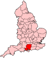
English: Map of the administrative county of Hampshire. |
| Source | Own work |
| Author | Wereon |
Licensing
| I, the copyright holder of this work, release this work into the public domain. This applies worldwide. In some countries this may not be legally possible; if so: I grant anyone the right to use this work for any purpose, without any conditions, unless such conditions are required by law. |
File history
Click on a date/time to view the file as it appeared at that time.
| Date/Time | Thumbnail | Dimensions | User | Comment | |
|---|---|---|---|---|---|
| current | 20:24, 22 April 2007 | | 200 × 247 (232 KB) | Wereon | Map of the administrative county of Hampshire. Category:Maps of counties of England |
File usage
More than 100 pages use this file. The following list shows the first 100 pages that use this file only. A full list is available.
- A33 road
- Aldershot
- B&Q
- BAE Systems
- Basingstoke Canal
- Bishop of Portsmouth (Catholic)
- British Aerospace
- British Airways Flight 5390
- Eastleigh
- Ecgberht, King of Wessex
- Farnborough, Hampshire
- Farnborough Airport
- Fratton Park
- Hampshire
- Highclere Castle
- History of Hampshire
- James Callaghan
- Lymington River
- M271 motorway
- Nab Tower
- Neil Gaiman
- Portsmouth
- River Avon, Hampshire
- River Blackwater (River Loddon)
- River Itchen, Hampshire
- Romsey (UK Parliament constituency)
- Rushmoor
- Solent University
- South Hampshire
- Southampton Itchen (UK Parliament constituency)
- Southampton Test (UK Parliament constituency)
- St Anne's Catholic School, Southampton
- Twyford Down
- University of Southampton
- Winchester Cathedral
- Talk:A27 road
- Talk:Aldershot F.C.
- Talk:Alton, Hampshire
- Talk:Andover Canal
- Talk:As Time Goes By (TV series)
- Talk:Atomic Weapons Establishment
- Talk:Basing House
- Talk:Benny Hill
- Talk:Bournemouth
- Talk:Carnival Corporation & plc
- Talk:Charles Dickens
- Talk:Charlotte Mary Yonge
- Talk:Christopher Hitchens
- Talk:Ecgberht, King of Wessex
- Talk:Elvetham Heath
- Talk:Farnborough Airport
- Talk:Fort Blockhouse
- Talk:Fort Cumberland (England)
- Talk:Fratton Park
- Talk:HMS Victory
- Talk:Hampshire
- Talk:Hayling Island
- Talk:Humphrey Lyons
- Talk:Hursley
- Talk:Hurst Castle
- Talk:Isambard Kingdom Brunel
- Talk:Jane Austen
- Talk:Joan Bates
- Talk:John Colborne, 1st Baron Seaton
- Talk:John Stonehouse
- Talk:Lymington River
- Talk:Marwell Zoo
- Talk:Neil Gaiman
- Talk:New Forest
- Talk:Peter Symonds College
- Talk:Petersfield
- Talk:Philippa Forrester
- Talk:Portchester
- Talk:Portsmouth
- Talk:Portsmouth Sinfonia
- Talk:Priory School, Portsmouth
- Talk:Queen Mary 2
- Talk:Richard Dawson
- Talk:Ringwood Brewery
- Talk:River Wallington
- Talk:Robert Lowth
- Talk:Royal Aircraft Establishment
- Talk:Sarah, Duchess of York
- Talk:South Downs
- Talk:Steve Lamacq
- Talk:Stratfield Saye House
- Talk:Swithun
- Talk:The Solent
- Talk:Tricorn Centre
- Talk:University of Southampton
- Talk:Vertu
- Talk:Winchester
- Talk:Winchester College
- Talk:Winchester College football
- Category:Hampshire
- Category:Hampshire cricketers
- Category:Portsmouth
- Category:Schools in Hampshire
- Category:Southampton
- Category:Towns in Hampshire
View more links to this file.
Global file usage
The following other wikis use this file:
- Usage on be.wikipedia.org
- Usage on br.wikipedia.org
- Usage on cy.wikipedia.org
- Southampton Itchen (etholaeth seneddol)
- Southampton Test (etholaeth seneddol)
- De Portsmouth (etholaeth seneddol)
- Gogledd Portsmouth (etholaeth seneddol)
- Eastleigh (etholaeth seneddol)
- Gosport (etholaeth seneddol)
- Meon Valley (etholaeth seneddol)
- Romsey a Gogledd Southampton (etholaeth seneddol)
- Havant (etholaeth seneddol)
- Fareham (etholaeth seneddol)
- Basingstoke (etholaeth seneddol)
- Aldershot (etholaeth seneddol)
- Dwyrain Fforest Newydd (etholaeth seneddol)
- Gorllewin Fforest Newydd (etholaeth seneddol)
- Gogledd-ddwyrain Hampshire (etholaeth seneddol)
- Gogledd-orllewin Hampshire (etholaeth seneddol)
- Dwyrain Hampshire (etholaeth seneddol)
- Caerwynt (etholaeth seneddol)
- Usage on en.wikinews.org
- Usage on es.wikipedia.org
- Usage on et.wikipedia.org
- Usage on fr.wikipedia.org
- Aldershot (circonscription du Parlement britannique)
- East Hampshire (circonscription du Parlement britannique)
- Fareham (circonscription du Parlement britannique)
- Gosport (circonscription du Parlement britannique)
- Havant (circonscription du Parlement britannique)
- Meon Valley (circonscription du Parlement britannique)
- New Forest East
- New Forest West
- North East Hampshire (circonscription du Parlement britannique)
- North West Hampshire (circonscription parlementaire britannique située dans le Hampshire)
- Portsmouth North (circonscription du Parlement britannique)
- Romsey and Southampton North (circonscription du Parlement britannique)
- Winchester (circonscription du Parlement britannique)
- Eastleigh (circonscription du Parlement britannique)
- Portsmouth South (circonscription du Parlement britannique)
- Southampton Itchen (circonscription du Parlement britannique)
- Southampton Test (circonscription du Parlement britannique)
- Liste des circonscriptions parlementaires du Sud-Est (région)
- Usage on fy.wikipedia.org
- Usage on id.wikipedia.org
- Usage on jv.wikipedia.org
- Usage on ko.wikipedia.org
- Usage on nl.wikipedia.org
- Usage on nn.wikipedia.org
View more global usage of this file.