
Jacques Cartier Bridge
Jacques Cartier Bridge | |
|---|---|
 | |
| Coordinates | 45°31′15″N 73°32′06″W / 45.52083°N 73.53500°W |
| Carries | 5 lanes of Route 134 |
| Crosses | St. Lawrence River |
| Locale | Longueuil, Quebec and Montreal, Quebec, Canada |
| Maintained by | Transport Canada |
| Characteristics | |
| Design | Cantilever bridge |
| Total length | 2 687.42 m |
| Longest span | 334.35 m |
| History | |
| Opened | May 14, 1930 |
| Statistics | |
| Daily traffic | 96,900[1] |
| Location | |
 | |
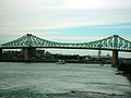
The Jacques Cartier Bridge (French: pont Jacques-Cartier) is a steel truss cantilever bridge crossing the Saint Lawrence River from Montreal Island, Montreal, Quebec to the south shore at Longueuil, Quebec, Canada. The bridge crosses Île Sainte-Hélène in the centre of the river, where offramps allow access to the Parc Jean-Drapeau and La Ronde amusement park.
Originally named the Montreal Harbour Bridge (pont du Havre), it was renamed in 1934[2] to commemorate the 400th anniversary of Jacques Cartier's first voyage up the St. Lawrence River.
The five-lane highway bridge is 3,400 m (11,236 ft) in length, including the approach viaducts. There are approximately 35.4 million vehicle crossings annually,[1] making it the second busiest bridge in Canada that is operated by the Federal Bridge Corporation Limited, the first being Champlain Bridge, just a few kilometres upstream. It is the third busiest bridge in Canada overall after the Port Mann Bridge in Metro Vancouver (connecting Surrey to Coquitlam).
Together with Champlain Bridge, it is administered by the Jacques Cartier and Champlain Bridges Incorporated (JCCBI), a federal agency which is a fully owned subsidiary of the Federal Bridge Corporation Limited.
Construction
Discussions began as early as 1874[3] about the construction of a new bridge to alleviate the congestion on Victoria Bridge, which was then a rail-only bridge, the wintertime ice bridge and the ferries used to connect the city to its south shore. The decision to build the bridge was made official in 1924.[3] Construction was undertaken by the Dominion Bridge Company starting in 1925 and completed in 1930. It was opened to traffic on May 14 of that year.
The bridge follows the general design concept of the Quebec Bridge. It was, in turn, one of the design influences for the Story Bridge, in Brisbane, Australia, which was completed in 1940.[4]
The bridge was originally designed as a road, tramway, and pedestrian bridge. Tramway tracks were installed but never used. A parallel empty space used to be to the right of the roadway in each direction, through which the bridge's girders could be seen. The roadway was expanded in 1956 and 1959[3] to include the space allocated to the tramway tracks, adding an extra lane of traffic in each direction. The two sidewalks were outside the bridge proper.
During the construction seasons of 1957 and 1958, the span over the east channel of the river (the Warren truss) was raised an additional 80 feet (to 120 feet). Traffic flow over the bridge was uninterrupted by this construction, through the installation of two Bailey bridges.[3]
The structure was a toll bridge from its opening until 1962[3] and a toll plaza was located on the southern approach. The toll plaza area now houses the offices of the corporation that owns and operates the structure and the nearby Champlain Bridge. Tokens were issued for part of the period that tolls were collected.
During 2001 and 2002 the entire deck of the bridge was replaced.[3] The sidewalks were also widened to a width of 8-foot (2.4 m), and the sidewalk on the western side of the bridge was made a bike path.
In 2004, a suicide prevention barrier was installed. Until then the bridge saw an average of 10 suicides a year.[5]
There are four 3-metre[citation needed] high finials, at the four high-points of the bridge, as architectural ornaments.[3] Their shape resembles the Eiffel Tower without being a replica.[3]

Events
During the summer season, the bridge is regularly completely closed to vehicular traffic for the fireworks competition held at La Ronde. It becomes foot traffic only, sometimes drawing crowds of 50,000+[citation needed]. In 2009 the competition runs fom mid-June till mid-August with events on Saturday nights only, commencing just before 10:00 PM. Bridge traffic is closed as of 8:00 PM, and is reopened when the bridge is cleared of pedestrians (usually between 11:00-11:30 PM).
Disruptions
This section possibly contains original research. (April 2011) |
Recently, this bridge has been shut down several times due to several protesters who have individually climbed on the superstructure of the bridge or on a sign in the Longueuil side of the bridge. Two of them were from the Fathers for Justice militant group, while a third claimed he was part of the group. Recently, a man wearing a Canadian flag climbed the structure of the bridge. Most of the protests led to massive traffic congestions during rush hour.
Gallery
-
 Jacques-Cariter Bridge from the Concorde Bridge
 -
 View from the bridge, before the suicide prevention barriers were installed
 -
Entering onto the Jacques Cartier Bridge going towards Longueuil
-
 Driving on the Jacques-Cartier bridge
 -
 Jacques Cartier Bridge at dusk
 -
 Jacques-Cartier Bridge


References
- ^ a b http://www.federalbridge.ca/Portals/0/annual_reports/fbcl_report_2006-07_eng.pdf
- ^ "The Jacques Cartier Bridge" (pdf). The Jacques Cartier and Champlain Bridges Incorporated. Retrieved 2008-08-25.
- ^ a b c d e f g h "Jacques Cartier Bridge (QC 134)". Retrieved 2008-08-25.
- ^ Gregory, Helen (2007). Brisbane Then and Now. Wingfield, South Australia: Salamander Books. p. 92. ISBN 9781741730111.
- ^ "La barrière anti-suicide a prouvé son utilité" (in French). Le Devoir. 2007-09-10. Retrieved 2008-08-25.
External links
- Jacques Cartier Bridge at Structurae
- Steve Anderson's MontrealRoads.com: Jacques Cartier Bridge (QC 134)
Bridges/Tunnels of the St. Lawrence River | ||||
|---|---|---|---|---|
| ||||