
Lo-Reninge
Lo-Reninge | |
|---|---|
City and municipality | |
.jpg) Old town hall and Belfry of Lo | |
 Flag  Coat of arms | |
Location of Lo-Reninge  | |
 Lo-Reninge Location in Belgium
Location of Lo-Reninge in West Flanders  | |
| Coordinates: 50°59′N 02°45′E / 50.983°N 2.750°E | |
| Country | |
| Community | Flemish Community |
| Region | Flemish Region |
| Province | West Flanders |
| Arrondissement | Diksmuide |
| Government | |
| • Mayor | Lode Morlion (Dynamisch) |
| • Governing party/ies | Dynamisch |
| Area | |
| • Total | 63.4 km2 (24.5 sq mi) |
| Population (2018-01-01)[1] | |
| • Total | 3,289 |
| • Density | 52/km2 (130/sq mi) |
| Postal codes | 8647 |
| NIS code | 32030 |
| Area codes | 058 |
| Website | www.lo-reninge.be |
Lo-Reninge (Dutch pronunciation: [ˌloːˈreːnɪŋə]; West Flemish: Lo-Rênienge) is a city and municipality located in the Belgian province of West Flanders. The municipality comprises the towns of Lo, Noordschote, Pollinkhove and Reninge. On January 1, 2006, Lo-Reninge had a total population of 3,306. The total area is 62.94 km2 which gives a population density of 53 inhabitants per km2. The Old Town Hall of Lo, built between 1565 and 1566, and its belfry were inscribed on the UNESCO World Heritage List in 1999 as part of the Belfries of Belgium and France site.[2]
It is the birthplace of Flemish painter Jacques-Albert Senave.
-
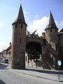 The 13th century city wall of Lo, with the Caesar's Tree behind it.
 -
 The Margriet windmill
 -
 Sint-Pieter's church in Lo

.jpg)
.jpg)
References[edit]
- ^ "Wettelijke Bevolking per gemeente op 1 januari 2018". Statbel. Retrieved 9 March 2019.
- ^ "Belfries of Belgium and France". UNESCO World Heritage Centre. United Nations Educational, Scientific, and Cultural Organization. Retrieved 5 November 2021.
External links[edit]
 Media related to Lo-Reninge at Wikimedia Commons
- Official website - Information available in Dutch and limited information available in French, English and German
Places adjacent to Lo-Reninge | ||||||||||||||||
|---|---|---|---|---|---|---|---|---|---|---|---|---|---|---|---|---|
| ||||||||||||||||
| Bruges |  | |
|---|---|---|
| Diksmuide | ||
| Kortrijk | ||
| Ostend | ||
| Roeselare | ||
| Tielt | ||
| Veurne | ||
| Ypres | ||
| ||
| International | |
|---|---|
| Geographic | |
This West Flanders location article is a stub. You can help Wikipedia by expanding it. |