Longueval
Longueval | |
|---|---|
 South African Commemorative Museum | |
| Coordinates: 50°01′34″N 2°48′15″E / 50.0261°N 2.8042°E | |
| Country | France |
| Region | Hauts-de-France |
| Department | Somme |
| Arrondissement | Péronne |
| Canton | Péronne |
| Intercommunality | Haute Somme |
| Government | |
| • Mayor (2020–2026) | Jany Fournier |
| Area 1 | 8.53 km2 (3.29 sq mi) |
| Population (2021)[1] | 279 |
| • Density | 33/km2 (85/sq mi) |
| Time zone | UTC+01:00 (CET) |
| • Summer (DST) | UTC+02:00 (CEST) |
| INSEE/Postal code | 80490 /80360 |
| Elevation | 123–157 m (404–515 ft) (avg. 150 m or 490 ft) |
| 1 French Land Register data, which excludes lakes, ponds, glaciers > 1 km2 (0.386 sq mi or 247 acres) and river estuaries. | |
Longueval (French pronunciation: [lɔ̃ɡval]) is a commune in the Somme department in Hauts-de-France in northern France.
Geography
Longueval is located 38 km (24 mi) northwest of Amiens on the D919 road, at the junction with the D8. Longueval is found in the north-east of the département, almost equidistant to the surrounding towns of Péronne (to the east), Albert (west) and Bapaume (north).
Population
| Year | Pop. | ±% p.a. |
|---|---|---|
| 1968 | 307 | — |
| 1975 | 267 | −1.97% |
| 1982 | 278 | +0.58% |
| 1990 | 237 | −1.97% |
| 1999 | 248 | +0.51% |
| 2007 | 268 | +0.97% |
| 2012 | 280 | +0.88% |
| 2017 | 271 | −0.65% |
| Source: INSEE[2] | ||
Heraldry
 |
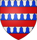
The coat of arms of the community were derived from the House of Longueval, Counts of Buquoy (later Bucquoy),[3] and are blazoned as:
Barry of six pieces vair and gules.
|
History

The village was almost completely destroyed during World War I.
World War I sites
Caterpillar Valley Cemetery is located outside Longueval, on the road to Bazentin.[4] The cemetery also contains a Memorial to the Missing from New Zealand, recording the names of 1272 men lost in 1916.[5] The body for the New Zealand Tomb of the Unknown Warrior was taken from here.
South of Longueval is the Longueval Road Cemetery. In the centre of the village is the Pipers' Memorial, built to commemorate bagpipers who fought in the First World War. Longueval was chosen because it was retaken by the 9th (Scottish) Division in July 1916. To the east of the village is the South African War Memorial Delville Wood.
On 21 October 2010, the Footballers' Battalions Memorial was unveiled at Longueval, near Delville Wood, to commemorate those from the Footballers' Battalions who had fought and died in the Great War.[6][7]
See also
References
- ^ "Populations légales 2021" (in French). The National Institute of Statistics and Economic Studies. 28 December 2023.
- ^ Population en historique depuis 1968, INSEE
- ^ Armorial universel: précédé d'un traité complet de la science du ..., Volume 2; By Joseph Louis Edouard Jouffroy d'Eschavannes, page 274.
- ^ Caterpillar Valley Cemetery at CWGC website
- ^ McGibbon, Ian (2001). New Zealand Battlefields and Memorials of the Western Front. Auckland: Oxford University Press. pp. 58, 83.
- ^ "League Honours War Dead". The Football League Official Site. Archived from the original on 12 June 2018. Retrieved 10 January 2011.
- ^ "Footballers' Battalion remembered on Somme battlefield – Telegraph". London: Henry Winter, The Daily Telegraph. 21 October 2010.
External links
- (in French) 360° Longueval Museum
- (in French) 360° Longueval Military cemetery


