Manning, North Dakota
Manning, North Dakota | |
|---|---|
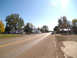
 Street in Manning | |
| Coordinates: 47°13′45″N 102°46′09″W / 47.22917°N 102.76917°W | |
| Country | United States |
| State | North Dakota |
| County | Dunn |
| Area | |
| • Total | 0.57 sq mi (1.49 km2) |
| • Land | 0.57 sq mi (1.49 km2) |
| • Water | 0.00 sq mi (0.00 km2) |
| Elevation | 1,834 ft (559 m) |
| Population (2020) | |
| • Total | 47 |
| • Density | 81.74/sq mi (31.58/km2) |
| Time zone | UTC-7 (MST) |
| • Summer (DST) | UTC-6 (MDT) |
| ZIP Code | 58642 |
| Area code | 701 |
| FIPS code | 38-50220[2] |
| GNIS feature ID | 2628576[2] |
Manning is a small town in, and the county seat of, Dunn County, North Dakota, United States.[3] Manning was founded in 1908 to serve as the seat of Dunn County, itself organized that year. Its population was not reported in the 2000 census,[4] but was included in the 2020 census, where a population of 47 was given.[5] Its ZIP Code is 58642.
| Census | Pop. | Note | %± |
|---|---|---|---|
| 2010 | 74 | — | |
| 2020 | 47 | −36.5% | |
| U.S. Decennial Census[6] 2020 Census[5] | |||
An unincorporated community, Manning, along with the surrounding inhabited vicinity, was designated part of the United States Census Bureau's Participant Statistical Areas Program on March 31, 2010, with the name of the Manning Census Designated Place[7]
Name
Manning was named after the pioneer rancher Dan Manning (1845–1914), who promoted the area.[8][9] It was originally suggested that the community be named Owensville after William P. Owens (1870–1913) because administrative work was carried out at his home, but Owens declined to have the community named after him.[9]
Climate
This climatic region is typified by large seasonal temperature differences, with warm to hot (and often humid) summers and cold (sometimes severely cold) winters. According to the Köppen Climate Classification system, Manning has a humid continental climate, abbreviated "Dfb" on climate maps.[10]
Notable People
Mel Ruder, Pulitzer Prize winning journalist was born in Manning.[11]
Education
It is zoned to the Killdeer School District.[12]
References
- ^ "ArcGIS REST Services Directory". United States Census Bureau. Retrieved September 20, 2022.
- ^ a b "US Board on Geographic Names". United States Geological Survey. October 25, 2007. Retrieved January 31, 2008.
- ^ "Find a County". National Association of Counties. Retrieved June 7, 2011.
- ^ U.S. Census Bureau (2003). "Population and Housing Unit Counts, North Dakota" (PDF). 2000 Census of Population and Housing. Government Printing Office. Retrieved July 20, 2008.
- ^ a b "Explore Census Data". Explore Census Data. United States Census Bureau. Retrieved April 22, 2022.
- ^ United States Census Bureau. "Census of Population and Housing". Retrieved October 30, 2013.
- ^ "Manning Census Designated Place". Geographic Names Information System. United States Geological Survey, United States Department of the Interior. Retrieved July 13, 2010.
- ^ "Dan Manning Dies at His Home in Dickinson Thursday Night". The Dickinson Press. Dickinson, ND. August 22, 1914. p. 2. Retrieved January 4, 2022 – via Newspapers.com.

- ^ a b Williams, Mary Ann Barnes (1966). Origins of North Dakota Place Names. Bismarck, ND: Bismarck Tribune. p. 99. Retrieved January 4, 2022.
- ^ Climate Summary for Manning, North Dakota
- ^ "Mel Ruder: Montana's first Pulitzer winner, dies at 85". Helena Independent Record. Retrieved November 28, 2020.
- ^ "2020 CENSUS - SCHOOL DISTRICT REFERENCE MAP: Dunn County, ND" (PDF). United States Census Bureau. Retrieved August 14, 2021.


