River Sett
Route map:
| River Sett | |
|---|---|
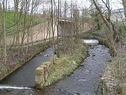
 The Sett passes under the A624 Hayfield "bypass". The tower of St. Matthew's church can be seen through the trees in the background, and in the foreground are the scanty remains of Walk Mill. | |
 The River Sett is highlighted in red Coordinates: 53°21′52″N 2°00′00″W / 53.36440°N 1.99990°W | |
| Physical characteristics | |
| Source | |
| • location | Kinder Scout |
| • elevation | c.540 metres (1,770 ft)[1] |
| Mouth | |
• location | River Goyt |
• elevation | c.130 metres (430 ft)[1] |
| Basin features | |
| Tributaries | |
| • right | River Kinder |
The River Sett is a river that flows through the High Peak borough of Derbyshire, in north western England. It rises near Edale Cross on Kinder Scout and flows through the villages of Hayfield and Birch Vale to join the River Goyt at New Mills.[1] The River Goyt is one of the principal tributaries of the River Mersey.
The 2.5-mile Sett Valley Trail follows the trackbed of the former railway line between Hayfield and New Mills.[2]
References
- ^ a b c The Peak District: Dark Park Area (OS Explorer Map), vol. OL1, Southampton: Ordnance Survey, 2009-02-02, ISBN 978-0-319-24067-0
- ^ Sett Valley Trail (leaflet produced by Derbyshire County Council Environmental Services Department)
KML is from Wikidata
