
River Wye

The River Wye (Welsh: Afon Gwy) is the fifth-longest river in the UK and for parts of its length forms part of the border between England and Wales. It is important for nature conservation and recreation.
Etymology
The Roman name for the River Wye was the "Vaga", which stems from vagus meaning to roam (vagor) or the wanderer. The Title map references a Vagas Field in both Whitchurch and Chepstow. [1]. The modern Welsh name "Gwy" may have lentited from the old Welsh "Gwybiol" or "Gwyr" (crooked wandering hills). [2]
Description
The source of the Wye is in the Welsh mountains at Plynlimon. It flows through or past several towns and villages including Rhayader, Builth Wells, Hay-on-Wye, Hereford (the only city on the River Wye), Ross-on-Wye, Symonds Yat, Monmouth and Tintern, meeting the Severn estuary just below Chepstow. The total length is 215 km.[3]
The Wye itself is a Site of Special Scientific Interest, a Special Area of Conservation and one of the most important rivers in the UK for nature conservation. Much of the lower valley is an Area of Outstanding Natural Beauty. The Wye is largely unpolluted and used to be considered[by whom?] one of the best rivers for salmon fishing in the United Kingdom, outside of Scotland. However, in recent years the runs of salmon in the Wye have declined dramatically and according to the Environment Agency rod catch returns for 2009 it is not even the most productive salmon river in Wales, as more salmon were caught from the Welsh Dee. In England the Tyne, Ribble, Wear, Lune and Eden all had larger catches in 2009. In 1967 the Wye rod catch was 7,864; as recently as 1988 it was 6,401 but by 2002 it was only 357, a low from which it is recovering only very slowly despite the extensive habitat improvement work carried out by the Wye and Usk Foundation that was set up to restore the spring salmon runs. The Wye was particularly famous for its large "spring" salmon that had spent three or more years at sea before returning to spawn. They used to enter the river between January and June and sometimes reached weights of over 50 lbs, the largest recorded being 59 lbs 8oz landed after a long fight by Miss Doreen Davey from the Cowpond Pool at Ballingham on 13 March 1923. The last recorded 50 lb rod-caught salmon from the Wye was taken in 1963 by Donald Parrish and weighed 51 lbs 8oz. These large spring salmon have virtually disappeared over the past two or three decades.
It is also a popular river with canoeists due to the relatively slow-flowing water, making it good for beginners. The Symonds Yat Rapids are more challenging. There is a public right of navigation downstream from Hay. Walkers can enjoy the Wye Valley Walk which follows the route of the River Wye from Coed Hafren to Chepstow along a series of well-maintained way-marked paths.
A viewpoint near The Biblins on the Wye is known as 'Three Counties View', the meeting place of the counties of Herefordshire, Gloucestershire and Monmouthshire. The lower 16 miles (26 km) of the river from Redbrook to Chepstow forms the border between England and Wales.
Tributaries
The Wye's tributaries include the rivers Lugg and Arrow, Elan, Dulas, Irfon, Marteg, Monnow, Trothy, Ithon, Llynfi, Letton Lake, Tarennig (the Wye's first tributary) and Bidno.
History

The Romans constructed a bridge of wood and stone just upstream of present day Chepstow. The River Wye was and still is navigable up to Monmouth at least since the early 14th century. It was improved from there to a short distance below Hereford by Sir William Sandys in the early 1660s with locks to enable vessels to pass weirs. According to Herefordshire Council Archaeology, these were flash locks.[4] The work proved to be insufficiently substantial and in 1696 a further Act of Parliament authorised the County of Hereford to buy up and demolish the mills on the Wye and Lugg. All locks and weirs were removed, except that at New Weir Forge below Goodrich, which survived until about 1815. This was paid for by a tax on the County. Weirs were removed all along the Wye in Herefordshire, making the river passable to the western boundary, and beyond it at least to Hay on Wye. A horse towing path was added in 1808, but only up to Hereford; previously, as on the River Severn, barges were man-hauled. Money was spent several times improving the River Lugg from Leominster to its confluence with the Wye at Mordiford, but its navigation is likely to have been difficult. The Wye remained commercially navigable until the 1850s, when commercial traffic moved to railways. It is still used by pleasure craft.

The Environment Agency is the navigation authority for the river. The Normal Tidal Limit (NTL) of the river is Bigsweir and navigation below this point is under the control of the Gloucester Harbour Trustees as Competent Harbour Authority.
The River Wye provides for canoeing and kayaking as it has sections suitable for all ranges of skills and free access all the way downstream from Glasbury through Hay-on-Wye to Hereford and the Severn Estuary.[5]
There are a wide range of canoe hire and supervised trips, as well as campsites at key points on the river. Symonds Yat has a particularly popular series of rapids that was purchased by the British Canoe Union in 2003 to preserve the rapids for recreational use.[6]
There are three rowing clubs on the river at Hereford, Ross-on-Wye and Monmouth. Annual regattas are held at Ross-on-Wye and Monmouth for rowers and scullers of all abilities, next to the local rowing club.
Cultural references
The Romantic poet William Wordsworth includes an apostrophe to the Wye in his famous poem "Lines Written a Few Miles Above Tintern Abbey" published 1798 in Lyrical Ballads
- How oft, in spirit, have I turned to thee,
- O sylvan Wye! thou wanderer thro' the woods,
- How often has my spirit turned to thee!
Views of the river
-

-

-

-
 Landscape with View on the River Wye by Thomas Jones
 -
 Eagle's Nest, Symonds Yat


Bridges on the river
-
 The old railway bridge at Redbrook
 -
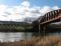 Monmouth viaduct and Duke of Beaufort Bridge at Monmouth
 -
 Chepstow Castle and bridge
 -
 Brockweir Bridge
 -
 Biblins Bridge
 -
-
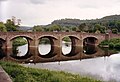
 Wilton Bridge, Ross on Wye
 -
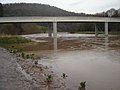
 Chepstow Bridge at very high tide
 -
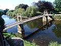 Victoria Bridge, Hereford
 -
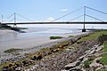 River Wye estuary and M48 Wye road bridge


See also
- Wye Valley
- Wye Valley Walk
- Wye Valley Railway
- List of rivers of England
- List of rivers of Wales
- List of bridges in Wales
References
- ^ The Tithe map (1844)
- ^ David Hancocks, Dean Archaeology No. 11, 1998 p39 ISSN: 0954-8874
- ^ Rivers and the British Landscape, (2005), Sue Owen et al., Carnegie Publishing, ISBN 978-1-95936-120-7
- ^ I. Cohen. "The Non-tidal Wye and its Navigation (from Transactions of the Woolhope Naturalists Field Club, 1958 pg 86-94)". Retrieved 2006-12-09.
- ^ River Wys boating (accessed 2008-04-270
- ^ "River rapids sold to canoeists". BBC News. 2003-03-15. Retrieved 2010-05-22.
Further reading
- I. Cohen, 'The non-tidal Wye and its navigation' Trans. Woolhope Nat. Fld. Club 34 (1955), 83-101;
- V. Stockinger, The Rivers Wye and Lugg Navigation: a documentary history 1555-1951 (Logaston Press 1996);
- P. King, 'The river Teme and other Midlands River Navigations' Journal of Railway and Canal Historical Society 35(50 (July 2006), 350-1.
- Chisholm, Hugh, ed. (1911). . Encyclopædia Britannica (11th ed.). Cambridge University Press.
External links
Transport in Monmouthshire | ||
|---|---|---|
| Road |  | |
| Bus | ||
| National Cycle Network | ||
| Railway lines | ||
| Railway stations | ||
| Waterways | ||
- Tributaries of the River Severn
- River navigations in the United Kingdom
- Rivers of Gloucestershire
- Rivers of Herefordshire
- Rivers of Wales
- River Wye
- Sites of Special Scientific Interest in Gloucestershire
- Sites of Special Scientific Interest in Hereford and Worcester
- Sites of Special Scientific Interest in Gwent
- Geography of Monmouthshire
- Forest of Dean
- Borders of England
- Borders of Wales
- Rivers of Powys
- Elenydd
- Severn drainage basin