
Sim Smith Covered Bridge
(Redirected from Sim Smith Bridge)
Sims Smith Covered Bridge | |
|---|---|
 North Portal | |
| Coordinates | 39°46′24.75″N 87°19′52.20″W / 39.7735417°N 87.3311667°W |
| Carries | C.R. W40N |
| Crosses | Leatherwood Creek, Indiana |
| Locale | Parke, Indiana, United States |
| Official name | Sims Smith Covered Bridge |
| Named for | Simeon Smith |
| Maintained by | Parke County |
| NBI Number | 6100060[1] |
| Characteristics | |
| Design | National Register of Historic Places |
| Total length | 102 ft (31 m)84ft +9ft overhangs on each end |
| Width | 16 ft (4.9 m) |
| Height | 14 ft (4.3 m) |
| History | |
| Constructed by | Britton, J.A. |
| Built | 1883 |
| Rebuilt | 1977 |
| MPS | Parke County Covered Bridges TR |
| NRHP reference No. | 78000411[2] |
| Added to NRHP | Dec 22, 1978 |
| Location | |
 | |
The Sim Smith Covered Bridge is east of Montezuma, Indiana. The single span Burr Truss covered bridge structure was built by Joseph A. Britton in 1883. The bridge is 101 feet (31 m) long, 16 feet (4.9 m) wide, and 14 feet (4.3 m) high.[3][4]
It was added to the National Register of Historic Places in 1978.[2]
Gallery[edit]
-
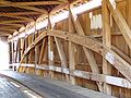 Detail of Burr Arch and King Posts
 -
 Detail of Abutment


See also[edit]
- List of Registered Historic Places in Indiana
- Parke County Covered Bridges
- Parke County Covered Bridge Festival
References[edit]
- ^ "National Bridge Inventory Database Search - 2016". nationalbridges.com. Archived from the original on 2019-02-02.
- ^ a b "National Register Information System". National Register of Historic Places. National Park Service. January 23, 2007.
- ^ "Sim Smith Covered Bridge". Parke County Incorporated / Parke County Convention and Visitors Commission. Archived from the original on 2012-04-19. Retrieved 2012-10-18.
- ^ "Indiana State Historic Architectural and Archaeological Research Database (SHAARD)" (Searchable database). Department of Natural Resources, Division of Historic Preservation and Archaeology. Retrieved 2016-06-01. Note: This includes Charles Felkner (December 1977). "National Register of Historic Places Inventory Nomination Form: Parke County Covered Bridge Historic District" (PDF). Retrieved 2016-06-01., Site map, and Accompanying photographs.
External links[edit]
 Media related to Sim Smith Covered Bridge at Wikimedia Commons


This article about a bridge in Indiana is a stub. You can help Wikipedia by expanding it. |
Categories:
- Covered bridges on the National Register of Historic Places in Parke County, Indiana
- Bridges completed in 1883
- King post truss bridges in the United States
- Wooden bridges in Indiana
- Burr Truss bridges in the United States
- 1883 establishments in Indiana
- Midwestern United States bridge (structure) stubs
- Indiana building and structure stubs
- Indiana transportation stubs
- Central Indiana Registered Historic Place stubs