
Talk:Portuguese Empire/Archive 1
| This page is an archive of past discussions. Do not edit the contents of this page. If you wish to start a new discussion or revive an old one, please do so on the current talk page. |
Improvement
Heh, anyone who takes a look at the history of this page is going to have fun sorting that all out. ;) -- John Owens 09:27 21 May 2003 (UTC)
- Heh. Yes. But the page is a marked improvement from its first version. :) Evercat 09:30 21 May 2003 (UTC)
- Heh, I hadn't looked at the first graffiti version before I suggested a move instead of a new page & redirect, maybe I would have left it alone if I'd seen that. -- John Owens 09:36 21 May 2003 (UTC)
Doubts
Was the Portuguese Empire "the first and largest colonial empire of the 16th century", as the article says? And the Spanish Empire? (see the opinion of Wetman in the end of Talk:Spanish Empire) --Gimferrer 19:32, 5 Apr 2005 (UTC)
- I've gone through the article and hopefully improved it stylistically. It still needs someone to pick through the factual assertions, however. Like you, I raised an eyebrow at the claim that Portugal's empire was larger than Spain's in the 1500s. There's also omissions, for example concerning the conquest of the Azores and Madeira, and the effect of the Napoleonic wars on the relationship with Brazil; and some tidying up and nitpicking is needed in the final listing of the various territories. This is my first ever attempt at this sort of thing, so I hope that I've not embarrassed myself! (Silverhelm 23:05, 15 August 2005 (UTC))
- I suppose the compartive size of the Portuguese ans Spanish empires depends on the exact date of comparison... The Ogre 14:33, 22 August 2005 (UTC)
If we take into account that the Spanish Crown, through Phillip II of Spain (I of Portugal), took control of the Portuguese possessions at the end of the 16th century, then the 'Spanish' Empire would be bigger! lol But before that 'outrage' (note: personal oppinion of a Portuguese lol), most of the Atlantic and Indian Ocean's coast of Africa, West Coast of India, Ceylon, etc, etc were under control of the Portuguese and compared with the Spanish terrritories in America, that were still struggling against the Mayans, Aztecs, etc, the Portuguese Empire had been bigger. De facto it had been bigger since its creation in 1415, after the conquest of the moorish city of Ceuta, wich, ironically, nowadays is under Spanish control.--Ciga 22:07, 24 December 2005 (UTC)
Yes, the Portuguese Empire was the first and largest empire in the first half of the XVI century. In terms of continents it was the most scatered, as it existed in at least 4 continents. Athough most of the territory inhabited were the mian coastal cities, technically their influence in the region was greater than any other in most cases not to mention that in large areas there weren't any oppositions that was seem as problematic but the main problem of the Portuguese settlers was that their numbers were few and the population in Portugal was already relatively low. Technically, by the year 1578 with the death of D.Sebastião, Spain was able to join all the Portuguese Empire with it's Empire, thuis creating the greatest empire of that time. But if you look at the total area under the rules of the Portuguese crown in the first half of the 1500s and compare it with the Spanish crown you will see that despite all Portuguese possessions are all scatered all around the planet, they still in total make a large area than the Spanish possessions, which were mostly limited to central america and Peru and in south america, the possessions were mostly in the north and coastal parts of Peru. .--Thorius Maximus 23:36, 30 July 2006 (UTC)
Portugal and its empire were ever part of the Spanish Empire. The two countries maintained its independence and their colonies were ruled separately, that's why when the personal union ended no problem existed concerning any land (although Ceuta was loyal to Philip III of Portugal [IV of Spain] and so did not returned to the Portuguese crown). So, from 1581-1640 there was not one empire, but two, ruled by the same king. The size is subjective. If you measure the area, the Spanish was bigger, if you measure the vastness, the Portuguese was bigger.Câmara 18:20, 17 April 2007 (UTC)
My apologies Câmara, you are right indeed concerning the Iberian Union, that last past in my coment was just a detail that I incorrectly described.
Thorius Maximus 12:26, 24 May 2007 (UTC)
Zanzibar
Thats part of Tanzania not Oman is it just a mistake or was there another place called Zanzibar?Falphin 22:09, 14 August 2005 (UTC)
- No it is Zanzibar in Tanzania. I've heard that there are even Portuguese speakers there. But I can't tell. -- Pedro 23:21, 14 August 2005 (UTC)
- There was Arab exploration, and I think to a small extent, colonization along the coast of East Africa. I'm ashamed to say that I've only got one book here on African history ("Africans: The History of a Continent", by John Iliffe, pub. Cambridge University Press), but it does have this: "It was probably this prosperity that led the rulers of Oman on the Persian Gulf to convert into real authority the nominal overlordship of the coast which they had claimed since leading opposition to the Portuguese there in 1698". I think that this is the origin of the sultanate that fought the famous forty-minute "war" with the British. (Silverhelm 23:05, 15 August 2005 (UTC))
- It is indeed Zanzibar, Tanzania. The territory went to Omani control the last time it switched hand from Portugual. I suppose it isn't really the purpose of this article to discuss the eventual fate of the former colonial possessions. In some cases it could've switched hands several times (while none concerning Portugal) before achieving today's status. --Kvasir 16:02, 23 August 2005 (UTC)
- There was Arab exploration, and I think to a small extent, colonization along the coast of East Africa. I'm ashamed to say that I've only got one book here on African history ("Africans: The History of a Continent", by John Iliffe, pub. Cambridge University Press), but it does have this: "It was probably this prosperity that led the rulers of Oman on the Persian Gulf to convert into real authority the nominal overlordship of the coast which they had claimed since leading opposition to the Portuguese there in 1698". I think that this is the origin of the sultanate that fought the famous forty-minute "war" with the British. (Silverhelm 23:05, 15 August 2005 (UTC))
Map of colonial posessions
I think a World Map of Portuguese colonial posessions throughout history is needed here! Dont' you agree? The Ogre 14:33, 22 August 2005 (UTC)
- I made a map of the Empire, but only during John III's reign. Tell me what do you thing in order for me to improve it. You can see it in Portuguese Empire or John III of Portugal. Thanks. Gameiro 05:10, 23 August 2005 (UTC)
- Hello João Pais / Gameiro! Good work on the map! Tell me: how do you do it? I'm interested in knowing how to do that. What program do you use? Now for some comments on the map.
- This is very good, but the article, as you very well know, is about the Portuguese Empire troughout history and not just during D.John III's reign. The idea I had in mind was a map depicting all of Portuguese colonial posesions (as the list Portuguese Empire#Territories of the Portuguese empire seems to show). This could be done with different colours for diferent time periods of actual control of territories. It would even be more perfect if the map could show voyages of discovery and exploration (land and sea) again all troughout history (or maybe this could be better in a topic of its own?).
- What does the difference between the green areas and the brown spots represent (I know they are green squares with a red border, but they look brown everywhere but the high-resolution version...)? It seems to me that the brown spots are cities, is that it? But still, why the diference?
- The island posessions are not very visible (even in the high-resolution version). Maybe they could be represented by a slightly larger and more visible dot (even if this is not cartographically very acurate)?
- What is the green spot (island) south of Madeira and north of Cape Verde? The Canary islands? I think they are much closer to mainland Africa...
- What areas did Portugal actually and effectively controled? All those green coastlines in Africa weren't "real" colonies, were they? I mean, maybe there were specific spots (such as Elmina Castle or the Fort of São João Baptista de Ajudá) effectively controled, but the rest was kind of just an area of influence and commerce, right? That difference should be visible on the map.
- I think it's everything... Do tell how the maps are done, maybe I could help! Keep up the good work! The Ogre 16:30, 23 August 2005 (UTC)
- P.S. - there seems to be a slight formating problem in the page due to the map. The first word of the first paragraph of the introduction ("The") is above the map and the rest of the intro is below. This needs fixing... or is it just my browser? The Ogre 16:30, 23 August 2005 (UTC)
- Hello João Pais / Gameiro! Good work on the map! Tell me: how do you do it? I'm interested in knowing how to do that. What program do you use? Now for some comments on the map.
- Well, first of all, thanks. I've worked hard on that map. Now your questions:
- I did the map on Adobe Photoshop but first copied one of the blank maps that you can find in here: Wikipedia:Blank maps.
- About your idea for the perfect Portuguese Empire map. Yes, I know that the map regarding John III's reign isn't sufficient but you can imagine what tremendous task it would be to build a map with all Portuguese possessions with: all the territories, plus minor cities and fortresses, effective control (but with no active presence) plus the voyages and chonological differences. If you are up to it then I wish you the greatest of lucks. My suggestion is to divide it by periods... One map it's impossible. I put the map during John III because it is the height of Portuguese control in all the continents.
- As for the brown spots... I was a bit disappointed when I saw the green squares with red border turn brown... It was supposed to represent a city or a fortress that was under Portuguese control and couldn't be seen if it was just a small green spot (like the islands of Azores). I thought that the red border would be fine but now I'm starting to dislike it.
- As for the islands size I don't think they can't be represented by a larger dot... It would be surreal. But I didn't try to enlarge them. I'll try it to see if it's fine.
- Sorry for the spot between Madeira and Cape Verde... It's just stupid. I forgot to delete it... It was an initial study for the "brown spots". I need to make some adjustments to the map.
- Yes, I believe you're right about the influence areas. I spent some time thinking about how could I make them seem different. As I said, I'm going to make adjustments. What do you think about making a differente lighter green area for the influence? And add that area to the coasts of India, Southeast Asia, Moluccas and perhaps southern China?
- As for the help. I would apreciated it. Be my guest and copy my map if you want, and make all the changes you want. If you want to do the task I proposed above (lighter green area or add Elmina and Ajudá) tell me something first. I'm a bit tired of making the map because I spent all night doing this one. If you'd help me would be great. If you need help with photoshop ask me in my talk page. As for my name is João Gameiro Pais, but I prefer Gameiro.
- Keep up the good work. Gameiro 17:16, 23 August 2005 (UTC)
I think that a map of all possesions of the Portuguese Empire of all times would be very illustrating, to say the least, to a lot of people. I get the impression that many English speaking people are not aware of the dimensions of the Portuguese Empire and certainly not aware that almost litterally everywhere they look in a world map they will see a Portuguese name of some location.--Ciga 22:19, 24 December 2005 (UTC)
- The Spanish territories in North America as seen in the article's map seem to be exaggerated. For example, it appears from the map that a large section of what is now the central United States was included in the Spanish empire whereas, in reality, those territories were actually under French control by the early 18th century.
Empire of Brazil
The header "Empire of Brazil (1640-1822)" is both inaccurate and misleading since no such entity existed in the aforementioned period. From 1549 till 1714, Brazil was a crown colony ruled by one or sometimes two Governor Generals. From 1714 till 1815, the colony was divided into two Viceroyalties, styled respectively the Viceroyalty of Brazil and the Viceroyalty of Grão-Pará. From 1815 till 1822, Brazil was elevated to the status of United Kingdom with Portugal and Algarve. It was only after 1822, when Brazil was already an independent country, that Pedro I used the title of "Emperor of Brazil" ( AFAIK, no Portuguese monarch had ever claimed that title before during the colonial period). (anonymous)
- I'm not the author, but that's not about a title, but an event. After India, Portugal turned to Brazil and then to Africa... but it maybe is misleading. --Pedro 13:16, 22 August 2006 (UTC)
Upper Peru?
The list of American colonies lists Upper Peru as colony in 1822. I can't find information on this anywhere, does anyone know the history? --Andrelvis 03:14, 12 June 2006 (UTC)
Upper Peru (today's Bolivia) was occupied by the Portuguese during the Napoleonic Wars. Since Spain was, until 1808, an ally of France, and the Portuguese Queen and Court had «withdrawn» to Brazil, the Spanish colonies became fair game for the Portuguese. Uruguay and the French Guyana were also occupied during this period, and remaind occupied for quite some time. In my opinion, however, to call Upper Peru a Portuguese colony is a bit far-fetched.--Nuno Gabriel Cabral 18:11, 28 June 2006 (UTC)
Cleaning up
This article needs someone whose native language is english to clean up some cumbersome sentences. "In 1433 Cape Bojador was doubled" <- Vê-se mesmo que isto foi escrito por um português. "Dobrado" vem de dobrar como em dobrar roupa e assim. Em inglês não existe coincidência entre dobrar de fazer o dobro e dobrar de dobrar roupa. -arcozelo
- Done as of yesterday. --maf 14:29, 22 August 2006 (UTC)
- This is still a big problem with this article. I've been trying to clean things up this weekend, but there is still a lot to do. The Red Hat of Pat Ferrick 13:53, 1 April 2007 (UTC)
Accuracy ...
.. could be disputed at present; e.g. Burma, Sri Lanka. The article implies that entire countries or territories belonged to Portugal, though the actual possession was limited to a few settlements, coastal areas, or was contested. Imc 18:54, 2 July 2006 (UTC)
Technically since there wasn't almost any opposition(and some of these costal settlemenst were taken through belical means), the autoctone populations weren't much of a danger to the securaty of the coastal possessions(due to the strong military presence in those cities), and since there weren't any opposition in the surrounding area, not to mention that many of these coastal cities were the economically and political centre of entire regions that could reach hundreds of miles, technically by taking the main coastal cities or dozens of miles, you also gain economical, political control of the region, that is, providing you have the necessary military power to continue having the city under your control, but it is also true that Portugal also tried to maintain teritorial control of the regions around these coastal cities, thus by saying that it was more that just the cities isn't entirely untrue. --Thorius Maximus 23:44, 30 July 2006 (UTC)
Terra Nova, Terra do Lavrador and Terra de Corte Real
I think portuguese exploration and colonization of this north american lands are not discussed here. Portugal was an active force on exploration of the north-eastern part of North America and de facto claimed these lands to Portugal (Cantino 1503 is the first map claiming this, showing Newfoundland as "Terra del Rey de Portugal", followed by Waldseemuller 1507 in wich Newfoundland is shown with the portuguese flag) and tried to colonise them in the 1520s (with João Álvares Fagundes). In several maps of the 16th century the portuguese shield is shown, as in João Vaz Dourado (I don't remember now exactly the year, but is from the middle of the century). I think the article and the map could talk about this subject more than a single dot in the map. These lands were really part of the portuguese empire and it seems nobody is pointing this, here and everywhere in wikipedia excluding, obviosly, the articles of the explorers.--Câmara 19:51, 25 July 2006 (UTC)
Then we should put these facts, we should also establish connections between these facts and Colombo's related facts, at is, if the sub article is made. --Thorius Maximus 4:05, 2 July 2006 (UTC)
Done. But how I can put the pictures with the copyright thing? The Cantino (and the João Vaz Dourado) maps are essencial in here!Câmara 02:09, 13 December 2006 (UTC)
Sugestions
I have some sugestions, please comment:
-I think the map should appear at the top of the page, and the "history of portugal series" after.
-I think the "begining of the empire" should be split because it's too big now, very massive. I think we can make some chapters in time: From Ceuta to Cape Bojador, From Cape Bojador to Cape of Good Hope, Tordesilhas and implications, the route to india, asiatic exploration, north american exploration, south american exploration and the height of the empire. Only after we can go to the Habsburg kings. Now we have like a super massive block having all these things together, it's not good to read, and I think is a mess. I sugest some more images too (maps, caravels, etc).
-I suggest to grow "The empire of Africa 1822-1945". Why not talking about portuguese explorers, the pink map (lol, I don't know if in english is like this).
-I think the territories of the portuguese empire should go to another page, here they are huge.
Please also comment the North American portuguese possession thing I wrote here.--Câmara 20:16, 25 July 2006 (UTC)
- Thanks for your suggestions Câmara. I encourage you to be bold and edit the article. I'll help you out in the process. It is obvious that this article needs a revamp. Those subdivisions you mentioned were pretty good. This lacks a good introduction by the way. Joaopais 01:31, 26 July 2006 (UTC)
- Second that. Edit live. A friendly hand will always be near to help if needed. --maf 14:31, 22 August 2006 (UTC)
- New sections, some more information. More sugestions, anyone?Câmara 02:10, 13 December 2006 (UTC)
Empire in the 20th century
How about a map?!? The Ogre 10:45, 24 October 2006 (UTC)
- Done it! The Ogre 14:55, 29 March 2007 (UTC)
- Good work, The Ogre. ;) How is with the XVI century map? There is discussion in the image talk and here too.Câmara 19:39, 29 March 2007 (UTC)
Please look carefully at Feb. 1/Feb 2 revisions
They look like troll-work - loss of the "independence of Spain?" NorCalHistory 12:28, 2 February 2007 (UTC)
- "The creation of a navigation school at Sagres by Henrique the Navigator allowed developments like the caravel and improved the quality of Portuguese cartography."
In Sagres:
- "Contrary to outdated studies that claim that prince Henry the Navigator gathered around him at his Vila do Infante, within the walls of an old Moorish fort on the Sagres peninsula, a school of navigators and map-makers, in fact he did none of this."
- "Contrary to outdated studies that claim that Henry gathered around him at his Vila do Infante on the Sagres peninsula a school of navigators and map-makers, in fact he did none of this. He did employ some cartographers to help him chart the coast of Mauretania in the wake of voyages he sent there, but for the rest there was no center of navigational science or any supposed "observatory"…"
What are the facts? — Athænara ✉ 11:00, 14 February 2007 (UTC)
If you want to know, recent studies indicate that there was a cartography and navigational center in Sagres, yet it was a minor one. The main installations and also for the departure of ship were all in Lisbon, and later voyages departure from Lisbon.
In fact if you must know, one of the main cartography centres and vesel research was in the Guadiana river because it's was a relatively isolated place, and the level of the waters in the Guadiana had risen in those times. That's were the caravel was developed. And no, the caravel was not developed by either the moors, or italians of anyone. The caravel's design is based on a model of a ship that was used by muslims in the mediterranian and shortly after also by venesians italians etc, yet this was only the basic design on some levels, in those naval centers they had to change the ship in order that it can sustain the sea waters, storms of the atlantic, it's cargo capacity had to be increased, yet without sacrificing the ship's speed etc.
The main cartography centre was in Lisbon. And from the entire mediterranian came cartgraphers and many of then were also from portugal since portugal was a nation in which the sea had an important part in it's economy.
There wasn't one observatory, there were several observatories. The astrobalious was already used by muslims yet they were very primite models, yet the quadrant was invented in portugal. The existing version at that time of the astrolabious had to be further developed in order to be appliable concerning star maps and orientation methods, and even the complexity of the astrolabious itself had to be develpoed.
If there is one field that historians say the kingdom of portugal at that time completely revolutionized without any external influences with the exception of maps that were brought by portuguese spies in far east such as Master Spy Pero da Covilha, it is cartography. Other fields would not have developed without portuguese influence, fields such as naval technology, astronomy and mathematics concerning geographical and planetary measures. Yet, it is true that Portuguese planetary calculations were based on the muslim one's, yet they had to be further developed.
When comparing the Navigator's time with the zenite of John II, Henry didn't do much, yet it is worth to be said that "he had to do the hard part in some fields".
Does the text in the page remain faithfull in most aspects to what I've said? Yes, don't forget this is a sum up of many things, thus some precision is sacrificed, yet the idea it presents is supported by historical researches.
Thorius Maximus 21:31, 18 February 2007 (UTC)
I've made an error here.
The main research center was indeed in Sagres, but it was not a school, such statement is a mith, it was in fact a citadel. With the death of Henry, everything was transfered to Lisbon, from then all voyages departured from Lisbon.
My apologies abou the mistake.
Thorius Maximus 21:29, 3 March 2007 (UTC)
An exploration = Empire?
Don't think so. Specially not when it has been explored before. --Arigato1 10:10, 24 March 2007 (UTC)
- I don't think your removals were sound, it is best to discuss on the talk page first. I've reverted your map removal and removal of Greenland from the list of territories. The fact tag is fine but not removing the map. ++Lar: t/c 03:32, 27 March 2007 (UTC)
- For once I agree with you, Arigato1. Exploring the area and making claims doesn't mean that Greenland was ever actually Portuguese. By around 1500 it had been a Norwegian possession for almost 250 years, with a 500 year West Norse settlement (with a Roman Catholic diocese under the Norwegian archdiocese in Nidaros) that had recently, or was, ebbing out. Denmark-Norway and, after the Treaty of Kiel, Denmark retained this possession. This, together with the fact that no permanent Portuguese presence seems to have existed in Greenland (which doesn't surprise me), leads me to believe that this was little more than a paper claim. There have been many of those through the times, and we can all be affected by national pride when we view history, but it is a pitfall we have to try to avoid.I think that in maps used in this article different colours should be used for actual possessions and areas that were explored. Anyway, a more interesting question is if the West Norse settlement and the Portuguese exploration actually overlapped. -- Nidator 20:46, 9 July 2007 (UTC)
- Wanna hear something funny? The Portuguese actually did visit Greenland, but they did so as part of a joint expedition with sailors from the Kalmar Union during the early 1470s. It was an initiative by King Christian I who wished to find a naval route to Asia, to enable both trade and crusades there (the idea was to attack the Ottoman Empire in the back). It is also likely that Christian I held similar beliefs as Christian II; that the fabled realm to Prester John was located in Asia, so the idea was to establish contacts with Prester John, who could then provide one of two simultaneous attacks on the Ottomans. (See: Michael Bregnsbo and Knud Villads Jensen: Det danske imperium. Storhed og fald, Copenhagen: Aschehoug, 2004, pp. 105-106.) Interestingly, this era records a number of connections between Portugal and Denmark. In 1448 a Danish nobleman named Vallarte took part in a Portuguese crusade to Cape Verde with the Order of Christ. Around 1465, a Danish herald, Lolland, took part in a few Portuguese crusades and expeditions to Northern Africa, and he was knighted by King Alfonso V. By 1471, a joint expedition led by Didrik Pining and Hans Pothorst (1 Dane, 1 Icelander) and João Vaz Corte-Real and Alvaro Martins Homem (both Portuguese) sailed for Greenland. The expedition apparently left a large symbol of its own presence on a Greenlandic mountain and then continued to Newfoundland. (Bregnsbo and Jensen, pp. 109-110.) However, if we consider these situations as parallels to each other, the first examples are Portuguese explorations with a few Danes mixed in while the reverse would probably have been the case to Greenland. In any case, surely Alfonso V couldn't be unaware that Christian I claimed sovereignty over Greenland although the latter didn't have any effective control over the island. Portugal and Denmark-Norway were on friendly terms and Alfonso had even spoken to a Danish herald who would have known all of his master's titles and claims by heart. Also, I don't see any reason why Portugual should have chosen to jeopardize good relations with Christian I by staking claims to obscure locations in Greenland. Valentinian T / C 21:43, 9 July 2007 (UTC)
- I have never come across that piece of information before, and it is a little surprising. In 1471 there could still be people in the Eastern Settlement. Does the book go into any greater length about the expedition? Has this "large symbol" ever been found? -- Nidator 23:03, 9 July 2007 (UTC)
- I'd never heard the story before either, and I only read this paragraph a few weeks ago. Unfortunately, the book's passage about these events is very brief, as the authors are more interested in King Christian I's journey to Italy. The book doesn't mention contacts with any Scandinavians on the island, but presumes that they were extinct by then. In Danish books, a wedding around 1408 is normally the last record mentioned about life in the Eastern Settlement. Christian II also had plans for a crusade to Asia that involved Greenland (since it was considered the easternmost part of the Asian mainland). These plans never materialized either due to the collapse of the union and Christian's imprisonment. I've never heard about anyone rediscovering this stone cutting or whatever it was. Most of the book's information is a short paragraph on page 109 which goes like this (quote) "Omkring 1471, da Christian forelagde sin store korstogsplan på Rigsdagen i Regensburg, afgik en ekspedition mod nord, ført af de kendte kaptajner Didrik Pining og Hans Pothorst fra Danmark og Island og João Vaz Cortez og Alvaro Martins Homem fra Portugal. De nåede til Grønland, hvor de satte et stort mindesmærke på et af de markante bjerge. Kontakten mellem Danmark og Grønland havde været meget svag gennem 1400-tallet, og måske er de sidste nordboere bukket under for inuit-angreb eller døde af sult. Fra Grønland fortsatte ekspeditionen til Amerika og nåede Newfoundland, der snart blev kendt blandt portugisiske fiskere som Terra do bachalau, Klipfiskelandet. Målet med hele rejsen var at finde nordvestpassagen til Indien. Det blev forsøgt igen senere". (unquote) (Bregnsbo and Jensen, p. 109). Perhaps "Dansk Udenrigspolitiks Historie, Vol I (Konger og Krige)" would contain more information? Valentinian T / C 07:49, 10 July 2007 (UTC)
- I wasn't aware that there had been any significant contact directly with Denmark at all before that, or until quite some time later. During the Norse period the trading ships came to Greenland via Iceland and later even directly from Norway, but perhaps they mean the whole realm of Christian I when they write Denmark? Yes, the wedding in 1408 is the last documented Greenlandic event, but, since contact with the outside world was dying out, it is difficult to say exactly when the last Greenlander died or left the island. In 1540 some Icelandic seafarers blown off course found a Greenlander, with clothes intact, lying face down on a beach in a fjord, but who knows how long he had been lying there ([1]). -- Nidator 10:36, 10 July 2007 (UTC)
- You're right, Bregnsbo and Jensen sometimes use the word "Denmark" for all the territories and countries united by the House of Oldenburg. This is one such example. Interesting about the 1540 find. It would have been interesting to know if Christian II's planned expedition would have been able to find any Scandinavian survivors in Greenland, but I don't think it ever set sail. The book mentions 1519 and I guess Søren Norby would have been preoccupied with wars in Sweden around that time. Valentinian T / C 10:53, 10 July 2007 (UTC)
- Yes, the downfall of the Norse Greenlanders is a very fascinating subject. Even if we will probably never now the whole story, I'm hoping we may still find out more. There is an Inuit story about the "Norwegians" being attacked by ships, with some escaping by sea and land ([2]), but, as the article says, it is not supported by the archeology. -- Nidator 18:32, 12 July 2007 (UTC)
Let's get an example. Let's think for example Ascension Island. If there was no population on Ascension Island, who ruled in there? It's not need to have a soldier in every square meter of land, there was international recognition and no other claim. So, even without soldiers in there Ascension Island would be of the UK. Portugal was not the first to explore Greenland, that's obvious, but in the 1500's Portugal explored it, Portugal claimed it, Portugal had recognition of it (treaty of Tordesilhas/Tordesillas by "Spain" and the Pope (the most important person at that time)) and nobody claimed it too (Denmark, Norway, England, etc). It is shown in lots of maps of that time. (We don't know if there was a colony there, probably no, and we don't know how strong the portuguese presence was there.) Think also in Canada. Canadian borders were defined before the total exploration of the country. In Persia Portugal explored all the coast, but had only Hormuz, so exploration is not the same as empire, as you say.
I said this on the portuguese empire image discussion:
"Portugal did have lands in North America (I'm including Greenland). They were not famous, that's why nobody knows about them (even in Portugal). João Fernandes "Lavrador" and Pêro de Barcelos explored Greenland and Labrador, but the date is matter of dispute (1492, 1495, 1498, 1499). AFAIK the letter of king Manuel I to João Fernandes giving rights of the lands he would discovert is only of 1499. After that Miguel and Gaspar Corte-Real explored Newfoundland and near coasts, in 1500-1501. They disappeared but some ships returned to Portugal. Another expedition was set to look for them. We do not know how many voyages went there. In 1521 João Álvares Fagundes asked permition to colonise those lands, and the king accepted. The colony was abandoned in 1526, and we do not know why. After that, we do not know if portuguese presence was significative or not, but fishermen continued to fish in Newfoundland.
This is the history. Unfortunately, portuguese discoveries were mostly secret, so we have very few documents. And we have maps. And maps that show those lands as portuguese.
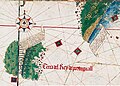
Cantino 1502 http://docenti.lett.unisi.it/files/33/1/6/1/cantino.jpg The first uncontroversial representation of Newfoundland (and maybe the land dispicted is also Labrador, connected to Newfoundland). And the name that appears is... "Land of the king of Portugal", and it has two portuguese flags in it. Greenland also has portuguese flags in it, although I cannot see what name appears above it. It is enough to show that those lands were portuguese. But let's analyze some more maps.
Ribero/Ribeiro 1529 search in internet We have a Land of Corte-Real and a Land of Lavrador. Interestingly, Greenland is connected to Labrador, wich might explain why Labrador visited both (remember there was a mini ice age in the 15th century, so maybe they were connected)
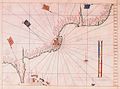
Waldseemuller 1507 http://docenti.lett.unisi.it/files/33/1/6/2/wald.jpg We have a land in North Atlantic with the portuguese flag (you may search for a coloured map, to see portuguese flag better). It may be Newfoundland or Newfoundland+Labrador or Newfoundland+Labrador+Greenland. I cannot tell what it is.
Lopo Homem 1519 hard to find We have a map of Newfoundland and Labrador with portuguese shields and lots of portuguese names
Vaz Dourado c.1576 search in internet We have again a portuguese shield and portuguese names
We have lots of another maps, and also about Fagundes.
I hope the Greenland/Newfoundland/Labrador thing is clear now, as they were short lived portuguese possessions. The only doubt I have in the map is the Barbados thing. I included it but maybe I shouldn't, I never heard of it and I just heard about it in the Portuguese Empire page. Anyway the map is clearly conservative, and is not fantasy nor BS. If you have doubts, just look at the documents and maps and books."Câmara 08:04, 27 March 2007 (UTC)
That's wrong. What is the sources for you think Greenland has been Portugiese?? --Arigato1 19:36, 27 March 2007 (UTC)
Did you saw the maps, especially Cantino? It is a claim, since the portuguese flag is in there. Câmara 20:36, 27 March 2007 (UTC)
This user seems to have a problem in accepting documented history, Perhaps the idea of a portuguese colony existing in newfoundand is not of your liking? Deal with it, thats's not our problem, it's yours.
By the way, the new map is very well done, yet the only thing I disagree(but that's just my opinion) are the pink regions in newfoundand and north america, they should the defined as colonized.
Thorius Maximus 20:36, 27 March 2007 (UTC)
- "Deal with it, thats's not our problem, it's yours." - not only is that a rather unpleasant order to a fellow contributor, but it really is your (pl.) problem. You need to provide references that back up this statement, otherwise it is a candidate for immediate removal from Wikipedia. That also means providing something more than some historical maps that place the Portuguese crest on the east coast of Canada: that alone is not evidence a colony existed: for you to make that conclusion is OR, plain and simple. I agree with Arigato1 - exploration is certainly not equivalent to empire, and it is misleading to suggest that it is. The Red Hat of Pat Ferrick 11:46, 1 April 2007 (UTC)
- BTW - this issue has "moved" to Evolution of the Portuguese Empire as I have branched off a sub-article in the manner of the Evolution of the British Empire vs British Empire distinction. The Red Hat of Pat Ferrick 12:24, 1 April 2007 (UTC)
- Well, we have some problems here. The first is called Treaty of Tordesillas. Just a question, when did Brazil become portuguese? I'll wait for answers.
Second: A map is a document, and so can be a reference. Maps can be very elucidative about some details. Third: Newfoundland and Labrador...not only some maps show them as a portuguese possession, there are lots of them, maps from 1502 to the latest half of the XVI century, from different countries... but OK, here are some references to "not maps" about portuguese presence there:
- ------ 1516–1521. Descobertas de João Alvares Fagundes, in Archivo dos Açores, IV (1882), 466–67.
- ARAÚJO, José Rosa de, Quem era João Álvares Fagundes, in Actas do Congresso Internacional Bartolomeu Dias e a sua Época, vol. II, Porto: Universidade do Porto - CNCDP, 1989, 363-368.
- BETTENCOURTE, E. A., Descobrimentos, guerras e conquistas, (Lisboa, 1881) 132–35.
- BIGGAR, H. P., Voyages of the Cabots and the Corte-Reals (1903).
- BRAZÃO, Eduardo, Os Descobrimentos Portugueses nas Histórias do Canadá, Lisboa: AGU, 1969.
- CANTO, Ernesto do, Quem deu o Nome ao Labrador?, in Arquivo dos Açores, vol. XII, 1892, 353-371.
- CORTESÃO, Armando, Cartografia e cartógrafos portugueses dos séculos XV e XVI, (2v., Lisboa, 1935), I, 287–88.
- GANONG, William F., João Álvares Fagundes, Vianense Ilustre, Donatário das Terras do Bacalhau, Lisboa, 1953.
- GANONG, William F., Crucial Maps (II) in the Early Cartography and Place-Nomenclature of the Atlantic Coast of Canada, in Transactions of the Royal Society of Canada, Third Series, Section III., 1956.
- HARRISSE, Henry, The discovery of North America: a critical, documentary, and historic investigation, with an essay on the cartography of the new world. (London, 1892), 182–88.
Fourth: Australia. Although I think portuguese explored it (at least), I think we should wait until more conclusive details are revealed, and so should not be included in the map (yet).Câmara 23:37, 1 April 2007 (UTC)
- This is the English language Wikipedia, so references in Portuguese can't be verified by the majority of contributors. Your two English language references were written in 1892 and 1903. You really need to provide contemporary sources. Here's one I found, which demonstrated why those maps aren't good sources: A History of Portuguese Overseas Expansion, 1400-1668 By Malyn Newitt: "The year 1500 had witnessed not only the discovery of Brazil but also the expedition of Gaspar Corte Real to explore the coasts of North America. Gaspar sailed a second time in 1501 but did not return, and his brother Miguel went in search of him in 1502. The Corte Reals obtained from the king the grant of the captaincy of Newfoundland and, although no settlements were made, their successors did begin the systematic exploitation of the Grand Banks. Maps of the period triumphantly showed the Portuguese banner flying over Greenland and Labrador (named after Jolio Fernandes who explored the coast of Greenland in 1499) both of which were confidently placed east of the Tordesillas line. However, Portuguese interest in the northern lands soon waned and nothing further was done to exploit these regions." On the other hand, The Portuguese Empire, 1415-1808: A World on the Move By A. J. R. Russell-Wood says "By 1500 (the Portuguese) had probably voyaged to Greenland, Labrador, and Newfoundland. By the 1520s they attempted settlement on Cape Breton island, and on Nova Scotia by mid-sixteenth century." So those are two conflicting contemporary sources. One thing is for sure, to claim these were "Portuguese lands" is stretching credibility somewhat. Yes, they were explored, but a few ships charting a coast does not equate to empire. Yes, grandiose claims were made by Portugal in their maps, but anyone can make a grandiose claim. Yes, possibly attempts at settlement were made, but they were unsuccessful. So they were never parts of the empire in the same way that, say, Brazil, Malacca, Macau and Goa were. If they must be on the map, they should clearly be marked in a separate category to the empire-proper. The Red Hat of Pat Ferrick 00:11, 2 April 2007 (UTC)
- Unfortunately there are very few contemporary English language writers interested in the Portuguese history of Newfoundland and Labrador, the ones interested in the Portuguese Empire are absorbed by Asia, Africa and Brazil. And again the settlements, the "exploration=empire?" thing... by the Treaty of Tordesillas Portugal had control of those lands, recognized by "Spain" and the Pope, the emerging power and the most powerful person in Europe (at least morally). Exactly like Brazil: in 1500 Portugal claimed it, but colonization, "settlementation", happened years after. And Brazil is everywhere recognized as Portuguese possession since 1500. Why? Because of the Treaty of Tordesillas. The same for Newfoundland and Labrador (and Greenland too): they were explored AND claimed almost at the same time as Brazil. Immediately, they become Portuguese possessions, with recognition of the two states ("Spain" and Pope) I referred before. Maps of the XVI century show Newfoundland and Labrador associated with Portuguese coat-of-arms. These maps are from different countries, so at least foreign cartographers were aware of Portuguese claim. Francis I of France did complain about the vicious monopoly of the Treaty of Tordesillas, for example, claiming also lands in this part of North America, but latter (and without the recognition Portugal had from other states), when Portuguese interests were different. So, even without settlement, those lands were Portuguese at least in the 1500-1520's period. We can say those lands were Portuguese at least de jure. Did Portugual had a de facto control of it? Possibly, we don't know, we don't have enough information to answer that. We know that in the 1500's (1506 I think) king Manuel I established taxes for the cod fished in Newfoundland, for example, but I never heard of how the control of the fisheries was made. In the 1500's the Corte Real family was the landholder of those lands, so maybe they did something there. Later we have João Álvares Fagundes, landholder too, of the lands between the Land of the Corte-Real (Newfoundland and Labrador) and the Spanish zones, who was given the right to settle and explore. Also about Fagundes:
- MORISON, Samuel Eliot. The European Discovery of America: The Northern Voyages, A.D. 500-1600. New York: Oxford University Press, 1971. and Portuguese Voyages to America in the Fifteenth Century. New York: Octagon Books, 1965.
- GOERTZ, Richard. João Álvares Fagundes, Captain of Terra Nova (1521), Canadian Ethnic Studies XXXIII:2(1991):117-128 Câmara 21:42, 2 April 2007 (UTC)
- The Treaty of Tordesillas wasn't recognised by England, France and the Netherlands though. Anyway, our argument on this is irrelevant, it's the sources that matter. The only point of agreement across them as far as I can see is that Newfoundland etc were visited by Portuguese explorers. Any statements beyond that - claims of settlement - are speculative, and should be marked as such on the map. BTW - instead of throwing the titles/authors of books or papers at me (which I can't verify myself), please quote the relevent sections of the sources like I did for you. Thanks. The Red Hat of Pat Ferrick 22:36, 2 April 2007 (UTC)
- First:I'm not throwing anything, I was just citing references that talk about Portuguese presence there. Sorry if it looked like that to you. I can't verify the references too, all I know is that, for example, Morison says that Fagundes established a colony in Breton Island, etc. Anyone who have these references will be a great help here. But like you said the references are everything. Second: In your first reference the author says Portugal claimed it (banners on maps of the period), that the Corte-Real had the captaincy of those lands and that theirs successors (fishermen?, other Corte-Real?) exploited it although no settlement was made, the second says Portugal attempted colonization. Your sources are only contradictory about Portuguese settlement, not about Portuguese "possession". That's why I called Brazil into question: in 1500 Portugal had no settlement in Brazil but it is shown as Portuguese possession since 1500. It is need to have a settlement? In Pedro Álvares Cabral page on Wikipedia it says that they "took possession of it by erecting a cross and holding a religious service"... (The Treaty of Tordesillas was not recognized by England nor France but they only entered with conflict with it latter [The period is the 1500-1520's, so Netherlands recognized the Treaty of Tordesillas because they were under Spanish control])Câmara 00:41, 3 April 2007 (UTC)
- Sorry, I didn't mean to offend with my use of the word "throwing". Anyway, for the references to be "admissable as evidence" the text really needs to be quoted (if challenged, which I am doing): it's not good enough to say that "I can't verify the references too, all I know is that..." Also, other WP pages aren't usable as sources. For a Wikipedia article or one of its maps to say that Newfoundland etc were "Portuguese colonies" or were "part of the Portuguese Empire", it needs to be demonstrated that this is the standard view of historians, and therefore that many contemporary sources can be found saying exactly that. I do understand your arguments re the Treaty of Tordesillas, but nevertheless you are making the mental leap from the fact that Portugal claimed possession to suggesting it was therefore part of its empire or a colony, but drawing that conclusion is WP:OR. The Red Hat of Pat Ferrick 01:01, 3 April 2007 (UTC)
- Yes, like I said before we need the references. Maybe someone here might provide them. Until then, this discussion is useless.Câmara 08:56, 3 April 2007 (UTC)
http://www.heritage.nf.ca/exploration/portuguese.html
http://www.heritage.nf.ca/exploration/early_ex.html
I'm still looking into more sources. Indeed I have not found an article saying by 100% that there was a colony, but in all articles I've seen, it is strongly suspected that indeed happened, nevertheless I'm still searching.
There is one thing wrong with the current map. It's the pink zones in newfoundland and labrador with interogation marks. Those maks should be removed but the pink zone should remain. All articles clearly state it's was explored and trade routes were created, thus the interrogations mark should disappear.
By the way, in an article about Cabot, it was said that the natives he found had a word for a certain fish which was Bacaalao. Coincidence hum? :P (cod existed in the portuguese coast, but it was extinguished in the early middle ages)
Thorius Maximus 23:02, 14 April 2007 (UTC)
- Okay. Since all sources state that those areas of North America were, at least, areas of exploration, I'l removed the question marks. Thanks. The Ogre 13:08, 15 April 2007 (UTC)
Well, that those areas were explored by the Portuguese is an undeniable fact. These are some maps of Nova Scotia, Newfoundland, Labrador and Greenland with the Portuguese coat-of-arms and/or the cross of the Order of Christ. They could be used for the article as some show also other Atlantic possessions of Portugal. I think the maps speak for themselves, showing that these lands were considered part of the Portuguese Empire:
-
 Cantino 1502
 -
 Reinel 1504
 -
 Kunstmann Map 1506
 -
 Maggiolo 1516
 -
 Reinel-Lopo Homem 1519
 -
 Reinel 1535
 -
 Viegas 1537
 -
 Lopo Homem 1554
 -
 Lazaro Luis 1563
 -
 Lopes 1570
 -
 Teixeira 1570
 -
 Teixeira 1573
 -
 Lasso 1575
 -
 Vaz Dourado c.1576
 -
 Lopes 1583
 -
 Lopes 1583


_02.jpg)


_00.jpg)
_05.jpg)
Câmara 01:53, 16 April 2007 (UTC)
I forgot Waldseemuller 1507, that also shows the Portuguese coat-of-arms in Labrador or Newfoundland or Newfoundland+Labrador or Newfoundland+Labrador+Greenland - the land in the Western North Atlantic.Câmara 17:52, 17 April 2007 (UTC)
Trade routes
Another thing, and this is just because of accuracy issues. I suggest that in the pink areas description be pointed one more things and that's the presence of trade routes. Although the presence of a colony in newfoundland, labrador and corte real is not confirmed, besides from explorations, there were indeed trade routes, and this also applies to many other regions. Thorius Maximus 14:12, 16 April 2007 (UTC)
- Done. In the caption is now writen "Pink - explorations, areas of influence and trade and claims of sovereignty". Cheers! The Ogre 13:42, 16 April 2007 (UTC)
Anachronous map of the Portuguese Empire (1415-1999)
Hello everyone! I just did and added an anachronous map of the Portuguese Empire (1415-1999). Please feel free to comment. Thanks. The Ogre 17:50, 30 March 2007 (UTC)
- The map has been moved to Evolution of the Portuguese Empire, but I still think it should be present in this article, namely at the begining, what do you think. I'll wait for your reactions before adding it or not! The Ogre 15:19, 1 April 2007 (UTC)
- Sounds fair. But (continuing our discussion from Talk:Evolution of the Portuguese Empire) I think that the pink and blue areas are not necessary. Instead, showing the exploration routes of the "famous" explorers would be better, alongside the colonies where Portugal really had sovereignty beyond a short stop or an indefensible claim. The Red Hat of Pat Ferrick 15:30, 1 April 2007 (UTC)
Just re-added the map. The Ogre 15:35, 1 April 2007 (UTC)
- What you propose would provoke a loss of info. What I would really like is an interactive map showing the evolution dinamically - but that is out of my league. And some of the pink areas were areas of real influence (eg the Kingdom of the Kongo or Ethiopia), others were real areas of discovery/exploration (namely the African coastlines), and the blue sea areas do represent, even if they don't have the exact routes of specific famous explorations, maritime areas of exploration and influence (though not in all the period between 1415 and 1999, obviously!). The Ogre 15:40, 1 April 2007 (UTC)
- On the other hand, leaving that information in there without prominent disclaimers is misleading. The theory that Portuguese sailors discovered the eastern coast of Australia is just that, a theory. I don't think a question mark does this matter justice. Furthermore, showing the exploration routes covers both your blue and pink areas, because it shows (a) the navigational routes followed and (b) the coasts explored. The Red Hat of Pat Ferrick 15:48, 1 April 2007 (UTC)
I'll try to work on it, still have some objections, but will voice them latter (sorry, I'm in a hurry just now!). For now, can we leave at that? The Ogre 15:54, 1 April 2007 (UTC)
- Sure. The Red Hat of Pat Ferrick 15:55, 1 April 2007 (UTC)
Thanks!! The Ogre 15:57, 1 April 2007 (UTC)
- The Red Hat of Pat Ferrick, I haven't forgot our conversation. I'm working on it. Thanks. The Ogre 16:17, 11 April 2007 (UTC)
Brazil was not in his borders of today part of Portuguese Empire. --J. Patrick Fischer 13:32, 6 April 2007 (UTC)
User:Luis_wiki Can you please remove the white border lines between current Brazil and Uruguai and Brazil and French Guiana? Thank You. Luis_Wiki
Incorrect Map - Canary Islands & Brazil?
Canarias Island never was included in the portugueses empire and part of the Brazilian territory was purchased after the independence, etc, etc. The map is only portuguese chauvinism. —Preceding unsigned comment added by 88.6.31.46 (talk • contribs)
- The map is not chauvinistic - my friend, assume good faith! And the map does not present the Canary Islands as part of the Portuguese Empire, they are in pink, that is to say, an area of "explorations, areas of influence and claims of sovereignty" - in this case a claim of sovereignty in the 15th century. The Canary Islands article states:
In 1402, the conquest of the islands began, with the expedition of Juan de Bethencourt and Gadifer de la Salle to the island of Lanzarote, Norman nobles who were vassals of Henry III of Castile. From there, they conquered Fuerteventura and Hierro. Béthencourt received the title King of the Canary Islands, but recognized King Henry III as his overlord. Béthencourt also established a base on the island of Gomera, but it would be many years before the island was truly conquered. The people of Gomera, as well as the Gran Canaria, Tenerife, and La Palma people, resisted the Spanish invaders for almost a century. Between 1448 and 1459, there was a crisis between Castile and Portugal over control of the islands, when Maciot de Bethencourt sold the lordship of Lanzarote to Portugal's Prince Henry the Navigator, an action that was not accepted by the natives or the Castilian residents of the island, who initiated a revolt and expelled the Portuguese. In 1479 Portugal recognised Castilian control of the Canary Islands in the Treaty of Alcaçovas.
- Regarding Brazil, the country's final frontiers would only be settled in the 20th century, but, grosso modo, it's modern configuration is largely the same as it was the day before the declaration of independence in 1822. If you can read Portuguese, check the article called Frontiers of Brazil in the Portuguese language Wikipedia (at Fronteiras do Brasil). Thank you. The Ogre 14:21, 6 April 2007 (UTC)
- Regarding Brazil, there are BIG differences. Large parts of Amazonia were not annected and 1874 was a war against Paraguay, where Brazil won a territory. --J. Patrick Fischer 17:15, 8 April 2007 (UTC)
Hello J. Patrick Fischer! I'll try to adress your objections some time soon (as well as other objections made by others), I promise. I just don't have the time right know. Thanks! The Ogre 18:44, 8 April 2007 (UTC)
- Hello again. I'll came back to the question of the Amazonian territory latter, but regarding the question with Paraguay, the Portuguese Wikipédia article on the Frontiers of Brazil states (my translation): "Regarding the frontiers with Paraguay the fixation of the frontier occured after the War of the Triple Alliance, when, in 1872, a peace treaty was signed with Paraguay in wich were specified the country's respective limites with Brazil, and that, according to historian Hélio Vianna (História da República e História diplomática do Brasil, São Paulo, Melhoramentos, 1957), respected the agreements of the colonial period and claimed for Brazil only the lands already occupied or explored by Portuguese and Brazilians." This reads to me as saying that the limits in 1822 were more a less the present ones indicated in the map. Wouldn't you say? See you soon! The Ogre 19:13, 8 April 2007 (UTC)
- However, going somewhat your way in this issue regarding the borders of Brazil and Paraguay (and also somewhat regarding the Amazonian issue) the present map of Brazil and that of 1822 do present some differences - see images bellow retrieved from States of Brazil. I'll try to correct the map of the Portuguese Empire accordingly. The Ogre 23:17, 8 April 2007 (UTC)
-

-
 1573
1573
Two states -
 1709
1709
São Paulo at its greatest -
-
 1823
1823
Imperial provinces -
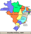 1889
1889
At the Start of Republic -
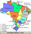 1943
1943
Border territories -
 1990
1990
Current


Corrected the map regarding Brazil - basically some changes to the Amazonian region, the border with Paraguay and the inner part of modern Santa Catarina state. Those areas were fomerly in red and are now in pink, since they were areas claimed by the Portuguese. The Ogre 20:32, 9 April 2007 (UTC)
Map of the Habsburg Kings' possessions
I'm removing the supposedly "map of the lands of the Habsburg kings in the period of personal union of Portugal (1580-1640)". you see, the map does not show the the lands of the Habsburg kings, but is an anachronous map showing areas pertaining to the Spanish Empire at various times over a period exceeding 400 years! As can be seen in the article Spanish Empire. Therefore, I'm removing it. Anyhow it was a bit strange to have an essencialy Spanish map as first map in an article called Portuguese Empire... The Ogre 20:59, 30 March 2007 (UTC)
- A Portuguese Empire map showing the Spanish Empire and the opposite are the same. That map is wrong because the Portuguese and the Spanish Empire were never fused (Portugal and Spain maintained the independence to each other). So that map is only right if it says "Map of the Habsburg kings from 1581 to 1640". Anyway if it is in the Spanish Empire page, it can also be used in the Portuguese Empire page as the Portuguese kings from 1581 to 1640 also had the possessions of the Spanish Empire... If this Spanish-Portuguese Empire map is used in one page, it should also be used in the other...Câmara 22:21, 17 April 2007 (UTC)
- I created this map:
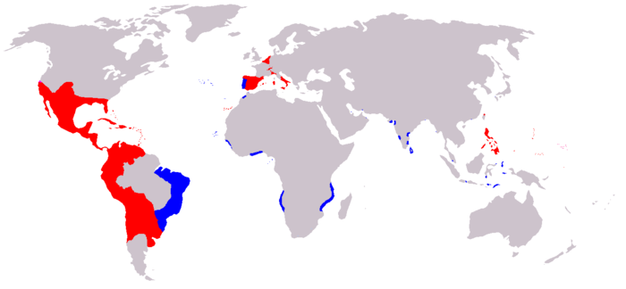 Câmara 23:55, 17 April 2007 (UTC)
- I created this map:

This refers only to 1580-160, right? The Ogre 15:14, 18 April 2007 (UTC)
- Yes, I tried to show only in that period, but it may have some errors. If for example a land was lost in 1582 it is also shown.Câmara 19:42, 18 April 2007 (UTC)
- Well, I do not have any informations about Portuguese territories west of Java or on New Guinea. Another question would be, if the whole coast of West India and East Africa were Portuguese or only some little towns and fortresses, but one thing for sure: Nagasaki is on the west coast of Kyushu, not at the north coast. ;) Greetings, --J. Patrick Fischer 08:32, 20 April 2007 (UTC)
- Oops...I will correct it later, but you're free to correct it too..:P The Portuguese territories in Indonesia are a mess, I can't find a clear source saying "this was portuguese, this was not". I copied the west Java from the previous Habsburg map. Well, the whole coast of Africa? The Portuguese were recognized as the "possessors" of it (you know, the eurocentric thing in those times) and even without settlements they had somewhat control/influence of it. That's why there is dark blue - colonies (a damn portuguese had a house and lived there) - and light blue - possessions without settlement (there were no houses, but recognized as portuguese by, at least, Spain and the Pope and/or under influence/control). I have put New Guinea when I was copying from the other map. I saw the Spanish New Guinea and the legend says "short lived possessions", and that's because of the Treaty of Saragoza who moved the antimeridian of Tordesillas to east, making most of New Guinea fall under Portuguese side. So, when I put the eastern New Guinea on Spanish zone, I have put the Portuguese as well. And again like Indonesia, the information we have are not clear. Greetings.Câmara 09:03, 20 April 2007 (UTC)
Hello Câmara. If you contact User:Merbabu, he may probably help you with Indonesia. Cheers! The Ogre 12:12, 20 April 2007 (UTC)
Question
What a great article! Well done! I'm a bit confused about the following para though - which sticks out like a sore thumb for poor expression and a lack of neutrality. "A not so well known and disputed fact is that a 16th century maritime map in a Los Angeles library vault proved that Portuguese explorers, not British or Dutch, were the first Europeans to discover Australia. The map, which accurately marks geographical sites along Australia's east coast in Portuguese, proves that Portuguese seafarer Cristóvão de Mendonça lead a fleet of four ships into Botany Bay in 1522 - almost 250 years before Britain's Captain James Cook.[1]" I suspect this just slipped in recently, un-noticed? Perhaps the author could re-word it in accordance with Wiki standards and the style of the rest of the article!--Nickm57 02:38, 23 April 2007 (UTC)
- Hello. Mr. Lack of Neutrality here. The provided source is working well. The unencyclopedic wording is a citation from a Reuters article, and anyone can easily reword it. http://www.reuters.com/article/topNews/idUSSYD3449720070321 Page Up 12:43, 23 April 2007 (UTC)
- The media tend to sensationalize things like this (remember Gavin Menzies' claim that "China discovered America"? He made it onto BBC World as a result, and sure sold a lot of books, but his view is still by far a minority one). What sells papers does not translate into mainstream opinion in academia, and Reuters journalists are not accredited historians or a form of academic peer review. Moreover, this is not a new theory. The paragraph you inserted from the Reuters article was therefore rather misleading, even your reworded form. I have reworded it accordingly. The Red Hat of Pat Ferrick 17:30, 23 April 2007 (UTC)
- Well done! But I see no reason to censor the Reuters external link with the article about the book which explains the theory and the author's sources.Page Up 10:51, 24 April 2007 (UTC)
- If one is citing the view of a particular historian or set of historians, those historians' works should be cited, rather than citing a website that cites those sources, if you see what I mean. As I say above, Reuters journalists are not accredited historians or a form of academic peer review. The Red Hat of Pat Ferrick 12:35, 24 April 2007 (UTC)
- I gave preference to the weblink because I don't have a library with that book near my office, only Internet, computers and other stuff. I've never seen that book, I confess. The first time I learnt about the theory was through Reuters and other news agencies some weeks ago.Page Up 14:29, 24 April 2007 (UTC)
- If one is citing the view of a particular historian or set of historians, those historians' works should be cited, rather than citing a website that cites those sources, if you see what I mean. As I say above, Reuters journalists are not accredited historians or a form of academic peer review. The Red Hat of Pat Ferrick 12:35, 24 April 2007 (UTC)
- Well done! But I see no reason to censor the Reuters external link with the article about the book which explains the theory and the author's sources.Page Up 10:51, 24 April 2007 (UTC)
- The media tend to sensationalize things like this (remember Gavin Menzies' claim that "China discovered America"? He made it onto BBC World as a result, and sure sold a lot of books, but his view is still by far a minority one). What sells papers does not translate into mainstream opinion in academia, and Reuters journalists are not accredited historians or a form of academic peer review. Moreover, this is not a new theory. The paragraph you inserted from the Reuters article was therefore rather misleading, even your reworded form. I have reworded it accordingly. The Red Hat of Pat Ferrick 17:30, 23 April 2007 (UTC)
- Hello. Mr. Lack of Neutrality here. The provided source is working well. The unencyclopedic wording is a citation from a Reuters article, and anyone can easily reword it. http://www.reuters.com/article/topNews/idUSSYD3449720070321 Page Up 12:43, 23 April 2007 (UTC)
Yes. The The Red Hat of Pat Ferrick is right. The maps proves nothing. The Theory of Portuguese discovery of Australia is just a possibility. Anyway, a "true" discovery (sorry for the eurocentric view) is going there and back and letting people know! Even if the Portuguese knew Australia, they sure didn't let know... The Ogre 08:10, 24 April 2007 (UTC)
Sorry Pageup/Mr Lack of Neutrality, no offense intended! However, the new text is clearer. I guess we'd better keep clear of Reuters... --Nickm57 10:37, 24 April 2007 (UTC)
Dont think so
First global empire? what about the Mongols? VanTucky 00:14, 26 April 2007 (UTC)
- Erm... in what sense was an empire confined to Asia and a bit of Europe a global empire? The Red Hat of Pat Ferrick 01:22, 26 April 2007 (UTC)
Oh, so we strictly mean global here. As in, must have occupied every continent not just multiple ones. In that case the article is correct. Just depends on the def of globla empire of course. And btw: the Mongols covered a hell of alot more territory than the Portuguese did, so saying just a little bit of Europe is rather silly. Have you seen the bloody map on the Mongol Empire page? VanTucky 01:25, 26 April 2007 (UTC)
- OK, calm down. This isn't an Olympic competition. Nowhere does the article claim that the Portuguese Empire was larger than the Mongol Empire. The Red Hat of Pat Ferrick 01:31, 26 April 2007 (UTC)
Map of the Spanish Empire
Hello everyone. Please come to Talk:Spanish Empire#Map and participate in the discussion. It pertains to the inclusion of the Portuguese Empire in the territories of the Spanish Empire during the period of the Iberian Union from 1580 to 1640. Thank you! The Ogre 13:06, 2 May 2007 (UTC)
- I think the maps they have there are ok.Page Up 14:36, 7 May 2007 (UTC)
Earliest empire
The conquest of the Canary islands began in 1402 with the expedition of Juan de Bethencourt and Gadifer de la Salle, who were vassals of Henry III of Castile, to the island of Lanzarote. The portuguese expansion began with the capture of Ceuta in 1415. So the extra-peninsular and extra-european expansion of the kingdom of Castile was earlier than the portuguese. Before that the aragonese had conquered several territories all over the Mediterranean. And what about the Roman empire? Conclusion: It is uncertain that the portuguese empire was the earliest at all. I don't understand the interest to eliminate every reference to Spain and the spanish in this article. —Preceding unsigned comment added by Ignaciogavira (talk • contribs)
- Hello Ignaciogavira. You should discuss this with The Red Hat of Pat Ferrick. Cheers! The Ogre 14:42, 30 June 2007 (UTC)
- Hello. Historical consensus (which is what is important to report, not your own original research) is that European seaborne "colonialism" began with the capture of Ceuta in 1415. I'll provide some references shortly - have to go out now. The Red Hat of Pat Ferrick t 14:54, 30 June 2007 (UTC)
- Here's a good an example as any you might find: [3]. The Red Hat of Pat Ferrick t 16:02, 30 June 2007 (UTC)
- Hello. Historical consensus (which is what is important to report, not your own original research) is that European seaborne "colonialism" began with the capture of Ceuta in 1415. I'll provide some references shortly - have to go out now. The Red Hat of Pat Ferrick t 14:54, 30 June 2007 (UTC)
Historical consensus about that? are you sure? Facts: Lanzarote (Africa and Spanish today) 1402, Ceuta (Africa and Spanish today) 1415. The historical consensus is that Spain and Portugal compited during the 15th century to expand their territories out of Europe (Spain inside too). It is a fact too that portuguese explored first the routes around Africa. The disputes between Castile (not Spain) and Portugal were resolved first with the treaty of Alcaçobas-Toledo, and after with the Treaty of Tordesillas. Those are historical facts, not "my own original research". Really you need references?
Anyway, my question is about the interest to eliminate any reference to Spain in this article. The other matters are quite controversial. In my oppinion refferences to Spain in the Portuguese Empire, and to Portugal in the Spanish Empire in the beginning of both are essential to make them really neutral. --Ignacio 18:07, 30 June 2007 (UTC)
- You are missing the point somewhat. (Did you even read the reference I provided? I guess not) The question here is what historians define as the beginning of European colonialism - from all the texts I have seen, they date it from Portugal's conquest of Ceuta in 1415. I have not seen any text say that it began with Spanish conquest of the Canaries in 1402. It would be original research to change the text based on your personal interpretation of the facts. Oh, and the Spanish Empire is mentioned, here. The Red Hat of Pat Ferrick t 18:28, 30 June 2007 (UTC)
OK maybe it is so that Castile explored those islands in 1402 but this wasn't the real change that the spanish needed to start their conquest!! it was from 1492 that the difference was obvious for Spain. In the Meanwhile the Portuguese explorer were already in South-Africa !! not to mention the attempts of Portugal to navigate West of the Azores (America)!!!! so that's why 1415 is synonim of the beginning of the exploration of the globe !!! —Preceding unsigned comment added by 151.92.176.3 (talk • contribs)
Portuguese Colonies in North America
Sorry for opening another thread on this, but the others are big and this new one can possibly captivate more people. I discovered a Portuguese source from 1570 by Francisco de Souza, "Tratado das Ilhas Novas" (Treaty of The New Islands) that mentions a Portuguese colony in Cape Breton Island. In Portuguese:
"Haverá 45 annos ou 50 que de Vianna se ajuntarão certos homens fidalgos, e pela informação que tiveram da terra Nova do Bacalháo se determinaram a ir povoar alguma parte d'ella, como de feito foram em uma náo e uma caravella, e, por acharem a terra muito fria, donde ião determinados, correram para a costa de Leste Oeste té darem na de Nordeste--Sudoeste, e ahi habitaram, e por se lhe perderem os Navios não houve mais noticia d'elles, sómente por via de Biscainhos, que continuam na dita Costa a buscar e a resgatar muitas coisas que na dita Costa há, dão destes homens informação e dizem que lhe pedem digam cá a nós outros como estão ali, e que lhe levem sacerdotes, porque o gentio é domestico e a terra muito farta e boa, como mais largamente tenho as informações, e é notorio aos homens que lá navegam; e isto é no cabo do Britão logo na entrada da costa que corre ao Norte em uma formoza de Bahia donde tem grande povoação; e ha na terra coisas de muito preço e muita nóz, castanha, uvas, e outros fructos, por onde parece ser a terra boa e assim nesta companhia foram alguns casais das Ilhas dos Açores, que de caminho tomaram como é notorio: Nosso Senhor queira por sua misericordia abrir caminho como lhe vá soccorro, e minha tenção é hir á dita costa de caminho quando fôr á Ilha de S. Francisco, que tudo se póde fazer d'uma viagem."
I will try to translate, so please point my errors:
"45 or 50 years ago (1520 or 1525) some fidalgos [small nobles] from Viana [very north of Portugal] group together and being aware of the news of Terra Nova do Bacalhau [Newfoundland], decided to colonise in some place of it, so they went in one nau and one caravel and found the land very cold, the one they had thought to go, they navigated the coast East-West until they found a Northeastern-Southwest one, and there they settled, and because the ships were lost there was no informations of them, information only came from the people of Biscaya [in Spain, basques], that continued in that coast gathering the things the coast gives [fish, probably]. This people [Basques] said that the Portuguese in there want to say to us [Portuguese in Portugal] how they live there, and ask to take them priests, beacause the gentios [I'm not sure, but I think they are refering the indians] are domestic [?] and the earth is very fertile, as I [Francisco de Souza] have information, and can be seen by the people that navigate there; and this is in Cape Breton, in the entry of coast that runs in North, in a beautiful bay that has great population; and exists there things that have great value and lots of nuts, chestnuts, grapes, and other fruits, where the land seems good and with them went some couples from Azores, that went with them when they passed there: that Our Lord may open way as give them help, and my intention [Francisco de Souza] is to go to that coast when I will go to the Island of St. Francis [Anticoste Island, my interpretation from an indication in this text (200 leagues west of Onze Mil Virgens, todays St. Pierre et Miquelon, and the island is 40 leagues long and 20 leagues wide], as both things can be done in one voyage."
Fagundes is from Viana, so almost surely he went with them (he had the captaincy of these lands).
A thought of mine: Samuel de Champlain mentions a portuguese colony that was only one winter long. Possibly this one-winter-long colony was in Newfoundland or East Cape Breton, the one they found too cold.
I was searching for this text and I found it in a site, which seemed to me respectable enough: http://www.gutenberg.org/files/21011/21011-h/21011-h.htm
Please comment, and please correct my attempt of translation :P Câmara 22:26, 23 August 2007 (UTC)
Was Portugal and its empire a part of the "Spanish Empire" between 1580-1640?
There is an ongoing discussion at Talk:Spanish_Empire about whether an anachronistic map of the Spanish Empire should include the Portuguese colonies as of 1580-1640 (indeed, Portugal itself), during the time of the Iberian Union, as "Spanish". The Red Hat of Pat Ferrick t 11:29, 30 September 2007 (UTC)
Salazar
Calling Salazar a "military dictator" is ridiculous. Salzar's was a right-wing authoritarian regime, but Salazar himself was not an Army man. He was an Enconomics Professor at Coimbra University. He was called upon by the Portuguse bourgeoisie to rescue their interests which were threatened by the economic crisis and social unrest. His policy was : stabilize the currency, cut social programmes, help the rich keep rich and help the poor accept their fate. No so far from what has become the dogma in neo-liberal circles and at the ECB ! Actually, Portugal became poorer and poorer as its currency continued to strengthen, accumulating gold reserves whereas the peasants were starving. One of Salazar's merits, however, was to have kept Portugal out of World War II (although his sympathies went to the US and UK allies, to whom he granted military facilities in the Azores). —Preceding unsigned comment added by 138.220.87.68 (talk) 21:01, 16 October 2007 (UTC)
- I agree--EuroHistoryTeacher (talk) 00:34, 7 January 2009 (UTC)
I agree!! what the fuck you know asshole. He was a great man,no different than any other good leader today.He looked after the country as a hole. All other nations were trying to fuck Portugal up (America & England) but he failed because he forgot to look at the Portuguese past history..... PORTUGUESE NEVER STAND TOGETHER AS A PEOPLES NATION.P.S. At times it sad for me to be Portuguese.
Dates don't match
I have read several articles about the Portuguese Empire from Wikipedia and Encarta encyclopedias. I read them in English, Portuguese, Spanish and Italian. Lots of the dates between these articles do not match (particularly on Wikipedia).
For the followings, I would like to know the date of discovery:
- Greenland
- Labrador
- Newfoundland
- Nova Scotia
- Madagascar
- Hormuz
- Diu
- Macao
- Damian
For the followings, I would like to confirm one and only one date of discovery:
- Madeira - 1418-9
- Senegal - 1444-5
- Cape Verde - 1456-60
- São Tomé e Príncipe - 1469-70-71
- Cape of Good Hope - 1487-88-89-90-91
- China - 1513-4
- Japan - 1541-2-3
If any of you knows the correct dates, please add a comment before correcting the encyclopedia.
ICE77 -- 84.223.77.237 19:12, 29 October 2007 (UTC)
- You know you can use the "search inside" feature of amazon.com and books.google.com to do this kind of research from the comfort of your own home? The Red Hat of Pat Ferrick t 23:41, 29 October 2007 (UTC)
Request for Comment - Dutch Empire map
Various alterations to the Dutch Empire map have been made, with no sources provided for these alterations. Would appreciate comment on the Talk:Dutch Empire page. The Red Hat of Pat Ferrick t 23:23, 25 April 2008 (UTC)
As the one above me has said, we are having a dispute. He claims this site is an unreliable reference despite the fact that they list where they got every single piece of information from. http://www.colonialvoyage.com/ (Red4tribe (talk) 23:27, 25 April 2008 (UTC))
- That personal site is not a credible academic source, and you map just seems like another attempt to enhance the areas under control of a specific empire. The Ogre (talk) 16:08, 26 April 2008 (UTC)
World War II
There's no mention of East Timor being invaded by the Japanese in World War II. —Preceding unsigned comment added by 124.107.159.125 (talk) 10:52, 30 April 2008 (UTC)
Decline and Fall 1960-1999?
how can an empire that was declining since the spanish hasburgs left Portugal appear as decling from the mid-20 century? i changed the title of the subheading to : "The last remnants of the empire". also im going to try to expand the Legacy part of the article :) --EuroHistoryTeacher (talk) 01:06, 29 November 2008 (UTC)
what the...?
"There is little evidence to support the notion that Portugal had actually become a real global power[1].While it did predominate the trade route around Africa, its function was more of an entrepreneur than a global power[2].Also it had no monopoly over the trade from the East as Venice had control over most trade entering into the Mediterranean[3]. Spain enjoyed more riches than Portugal in the Treaty of Tordesillas, as the Incan and Aztec prizes fell into its sphere of influence[4].Claims of Portugal's super power status are further vitiated by observing its swift conquest by and absorption into Spain later by the 16th century[5].Even extent of its victories over Muslim naval power in the Indian ocean has been questioned with the observation made that the Ottoman holdings and commercial enterprises were little affected by Portuguese military and naval operations[6]. "
Somebody wrote this in the "The last remnants of the Empire" , i have no idea what it has to do there so i deleted it --EuroHistoryTeacher (talk) 01:27, 29 November 2008 (UTC)
Only after 1535 Ottomans enter in Red Sea by Egypt, persecuted by the Portuguese in Red Sea(even in its beginning of its "fall" as dominant empire) The Turkish Threats on Diu or any another Portuguese position in India or Arabia had failed, after 1540s Portugal already did not have absolute (or majority until that) commercial monopoly in Indian Ocean. This had reflections in the terrestrial commerce.(a response to that statement by Somebody, not to you here ok!)
- An anonymous editor keeps readding it and the other editors here keep removing it. Good job for removing it again: it's totally inappropriate. The Red Hat of Pat Ferrick t 01:32, 29 November 2008 (UTC)
WT? but Indian Ocean was a Portuguese Lake, with 22 cities in west coast of India, more than half Ceylon, Oman(Muscat and all major cities and fortresses in Oman - Arabia Peninsula), Bahrein(Arabian p.), Queshem and Ormuz in Persian coast, part of today Emirates(Arabian Peninsula) and from Brazil to Moluccas, Macau and Deshima. For some years the thalassocracy was total with expeditions to the coasts of the Sinai, against the still incipient but increasing Turkish positions in Egypt(its fleet in particular) and attempts for one year in Basrah(Iraq). Of course 1540 -1550(even years before) mark a long decay and loss of domain in this maritime and commercial empire.
Portuguese Empire
The first Global Empire was Portugal - for the degree of its expansion in determined chronological time, without forgetting that Spain became the main global power in the second half of XVI century in Europe (where Portugal had only its own continental and Atlantic territory) and in the world as colonial power(in its part of North America and in its part of Oceania by the half part that fit to it in the treat of Tordesillas and Zaragoza/Elvas) - and that the global empire (or empires) the first one, was a deed of both Iberians.
In 1500-1501 - the first one in 4(or 5) Continents and the first one in some subcontinents - and with the first Establishments in the Moluccas, Ceram and Bante Islands in 1512-1513 the first in 5(or 6) Continents - in fact already in the Australian continental plate - and proclaiming nominal domain on west Papua (New Guinea) in 1526.
Let us respect the truth and history.
The article is very good and interesting but it can be more clearly in the first paragraph. Is good.
Empire:
EUROPE(EUROPEAN PLATE and AFRICAN OCEANIC PLATE)
PORTUGAL - Continent; Azores; Madeira(Selvagens)
MOROCCO:
Aguz (1506-1525) Alcácer-Ceguer (1458-1550) Arzila (1471-1550, 1577-1589) Azamor (1513-1541) Ceuta (1415-1640) Mazagon (1485-1550, 1556-1769) Mogador (1506-1525) Safim (1488-1541) Agadir (1505-1769) Tanger (1471-1662) Ouadane (1487- midle XVI)
AFRICA(SOUTH OF SAHARA):
ANGOLA (1575-1975) Cabinda-(1883-1975)
ANO BOM (1474-1778)
MAURITANIA: Arguim (1455-1633)
CAPE VERDE(1462-1975)
GANA: São Jorge da Mina (1482-1637) Costa do Ouro (1482-1642) Acra (1557-1578) FERNANDO PÓ (1478-1778)
GUINEA BISSAU: Guiné Portuguesa (1879-1974)
KENYA: Melinde (1500-1630) Mombaza (1593-1698, 1728-1729)
MOZAMBIQUE (1501-1975)
MADAGASCAR: Nominal - a base(necessary to review the sources)
TANZANIA: Kilwa (1505-1512) Zanzibar (1503-1698)
BENIN: Fortress of São João Baptista de Ajudá (1680-1961)
SÃO TOMÉ E PRINCIPE (1753-1975)
SENEGAL: Ziguinchor (1645-1888)
YEMEN(ASIA- "near" AFRICA): Socotra (1506-1511)
And more several areas of influence, indirect domain or tributaries Kingdoms in Africa, Asia etc. —Preceding unsigned comment added by 212.113.163.75 (talk) 11:47, 5 December 2008 (UTC)
ASIA
ARABIAN Peninsula:
BAHREIN(ARABIAN PENINSULA):
Bahrein and Al Qatif (1521-1602)
OMAN-(ARABIAN PENINSULA) and ARAB EMIRATES:
Muscat(1515-1650) Doba, Libedia, Corfação, Mada and Quelba (1515-1650)
SAUDI ARABIA and U. ARAB EMIRATES:
Khasab, Julfar(1515-1650)
IRAN -PERSIAN Coast:
Hormuz (1515-1622) Comoron (1515-1622) Qeshem (1515-1622) Bandar Abbas (1506-1615)
INDIA:
Laquedives Islands (1498-1545) Baçaím (1535-1739) Bombay (Mumbai) (1534-1661) Calecute (1512-1525) Cananor (1502-1663); Chaul (1521-1740) Chittagong (1528-1666) Cochim (1500-1663) Cranganor (1536-1662) Dadrá e Nagar-Aveli (1779-1954) Daman (1559-1962) Diu (1535-1962) Goa (1510-1962) Hughli (1579-1632) Nagapattinam (1507-1657) Paliacate (1518-1619) Coulan (1502-1661) Salsette (1534-1737) Masulipatão (1598-1610) Mangalore (1568-1659) Surate (1540-1612) Thoothukudi (1548-1658) São Tomé de Meliapore (1523-1662; 1687-1749)
SRY LANKA:
Portuguese CEILON (1518-1658) Half Island, all west to the interior and part of the east.
MALDIVES (1518-1521, 1558-1573)
CHINA:
Macau(1515 - 1557-1999)
JAPAN:
Deshima(Nagasaki)-(1571-1639)
ASIA, AUSTRALASIA and OCEANIA
MALAYSIA:
Malacca(1511-1641)
INDONESIA and PAPUA:
Coastal Forts in Sumatra (XVI century) Flores Island (XVI-XIX) Makassar(1512-1665) Bante- Banda (XVI-XVIII) Moluccas(Maluku): (1512 - Discovery - Amboina 1576-1605, Ternate 1522-1575, Tidore 1578-1650) West Timor(until XVIII century) Solor Islands(Middle of XVI century to 1850)
EAST TIMOR(1642-1975):
Discovery-1512-1517 process of Independence -Indonésia -Timor Timur (1975-1999) "Protectorate" UN(1999-2002)
NORTH AMERICA
CANADA:
Newfoundland Factory(1501--1503) Only Claims of Nominal Possession of LABRADOR and TERRA NOVA by the King (1501-1570) - Terras del Rey de Portugal Colony established by João Alvares Fagundes(It lasted 3 years after 1521) in Newfoundland. —Preceding unsigned comment added by 212.113.163.75 (talk) 11:53, 11 December 2008 (UTC)
SOUTH AMERICA
BRAZIL(1500-1822)
BARBADOS- a Factory (1536-1620)
URUGUAY: Nova Colónia do Sacramento (1680-1777) Cisplatine Province (1808-1822) - Ocupation (Expantion of Portuguese Brazil and Empire of Brazil) Change between Portugal and Spain many times.
FRENCH GUIANA (1809-1817)Conquest and ocupation. (to complete)
"Portugal's exploration and trade with most of the Western and Eastern coasts of Africa, Eastern South America, and Western, Southern and Eastern Asia, was the first major trade based form of globalization. A wave of global trade, colonization, and enculturation reached all corners of the world." and for First Global Empire "Portugal began establishing the first global trade network and empire under the leadership of Henry the Navigator."
Modelski and Thompson state that in the 16th century is frequently not recognized the true paper of the Leader Portugal in the Global Economy(already global - Brazil-Moluccas-Pacific before Cortés set foot in Mexico). Martin Paige wrote "The First Global Village,How Portugal changed the world —Preceding unsigned comment added by 212.113.163.75 (talk) 12:14, 16 January 2009 (UTC)
Alex MacGillivray admits that Portugal was strategicaly,technicaly,comercialy more Global than Spain.Michel Chandeigne lead the very sugestive book "Lisbonne hors murs.1415-1580.L'invention du Monde par les navigateurs portugais".Leo Huberman atributes the Portuguese "the Leading Role of the "trully international" comerce".
"Union with Spain"
The words "union with Spain" for the heading of the Iberian Union section are perfectly acceptable.
- The History of Portugal By James Maxwell Anderson [4] has an entire chapter called "Union with Spain".
- Portugal By Tom Gallagher [5] has a section entitled "Iberian Union".
The Red Hat of Pat Ferrick t 01:24, 5 December 2008 (UTC)
New Map
I have uploaded a new map, Image:The Portuguese Empire.png, which has labels and dates, in a similar style to Image:The British Empire.png. I believe this map is more useful than one with a million dots everywhere, leaving the reader to wonder what they mean. The use of illustrative not-to-scale squares for trading posts, forts and settlements avoids the problems of original research that inevitably arise when editors decide for themselves the extent of the areas that should be shaded. Note that it is a map of the principal forts and trading posts and is not meant to be an exhaustive list such as can be found at Evolution of the Portuguese Empire. I will add the sources used shortly to the image description at Wikicommons. The Red Hat of Pat Ferrick t 01:01, 5 January 2009 (UTC)
- To the anonymous editor reverted this change: please engage here first. The Red Hat of Pat Ferrick t 00:08, 7 January 2009 (UTC)
- I dont think such map is necessary also it doesnt look as good as the one from before--EuroHistoryTeacher (talk) 00:27, 7 January 2009 (UTC)
- The previous map borders on useless for the reader. What are all those red dots? What do they mean? How should the reader locate the places mentioned in the text? Please think about the reader first over pretty colours. Wikipedia exists for the benefit of people looking up information rather than people who like to make maps. The Red Hat of Pat Ferrick t 00:30, 7 January 2009 (UTC)
The new map is a big improvement, but seems to show Uruguay - an error, I assume, or if not then requiring explanation. Ghmyrtle (talk) 10:59, 7 January 2009 (UTC)
- Thanks. Feedback was positive at Talk:British Empire too, though a couple of suggestions were made regarding less use of arrows. Will address that shortly. The Red Hat of Pat Ferrick t 01:14, 8 January 2009 (UTC)
- When i say "it doesnt look as good as the one from before"- i mean exactly for the reader, the one from now is too small concerning portuguese expansion, maybe if you could show all the claimed/exploration/etc areas as is it right now but with the labels then it would be better.
- Ghmyrtle no, Uruguay is right being shown in the PE--EuroHistoryTeacher (talk) 20:11, 7 January 2009 (UTC)
Message for EHT/LOL Ferrick
EHT wrote: "stress fact that the dutch (NETHERLANDS) returned brazilian-held land 'cause it gives notion that they conquered all brazil)"
- You completely misunderstand the map, or have a messed up monitor, or are colour blind, or any combination of the above, if you think that this map shows Brazil as belonging to the Netherlands.
- Brazil is shaded BLUE. The Netherlands are shaded LILAC.
- The first Dutch attack on Brazil was in 1624 at Recife. This map is dated 1598.
I do not for the life of me know how you can get the notion that this map suggests the Dutch conquered all of Brazil, when the territory is clearly shaded Portuguese. The Red Hat of Pat Ferrick t 00:17, 7 January 2009 (UTC)
- HAHHAHAHAHAHAHAHHA you just made my day ferrick LOL hahaha hahaha hahaha omg lol imagine if i really was saying that?! LOL what i meant was the SENTENCE ONLY , it said the nertherlands returned brazil to portugal (or something similar) which is wrong the dutch didnt even conquered a large piece of brazil, just the coast around recife, that sentence kind of implied that the netherlands conquered Brazil, but now its fixed.
- Also i Trasamundo's map is not correct, why do you keep using it? Im reverting it (the iberian union map of Trasamundo) and im also reverting the map of the portuguese empire at the intro, let more of us editors discuss it first please. Thanks Ferrick--EuroHistoryTeacher (talk) 00:32, 7 January 2009 (UTC)
- Then I will put back the original Iberian Union map, as you never allowed anyone to debate your new map before you added it here last week, did you? The Red Hat of Pat Ferrick t 00:35, 7 January 2009 (UTC)
Obrigado Ferrick--EuroHistoryTeacher (talk) 00:48, 7 January 2009 (UTC)
Oh dude i didnt even notice the difference between those 2 maps in the PE page until now. Btw this map File:Iberian_Union_Empires.png is WRONG and innacurate, the portuguese lands werent limited to the angolese and mozambique coast, they extended much further north and south (in portuguese east africa for example the portuguese reached the Horn of Africa (somali horn).--EuroHistoryTeacher (talk) 01:05, 7 January 2009 (UTC)
Red hat of Pat Ferrick
He says he want to discuss his proposed map, so go ahead Pat.--EuroHistoryTeacher (talk) 01:13, 7 January 2009 (UTC)
- Why don't you begin by explaining why you reverted my map? The Red Hat of Pat Ferrick t 01:17, 7 January 2009 (UTC)
- I have already. 2nd this article is about the Portuguese Empire not the portuguese main forts around the world--EuroHistoryTeacher (talk) 20:07, 7 January 2009 (UTC)
- The Portuguese Empire article does not mention every single Portuguese fort and trading post, does it? That is what Evolution of the Portuguese Empire is for. The map on Portuguese Empire should complement the text and allow the reader to locate the places mentioned therein. The Red Hat of Pat Ferrick t 02:47, 8 January 2009 (UTC)
- I have already. 2nd this article is about the Portuguese Empire not the portuguese main forts around the world--EuroHistoryTeacher (talk) 20:07, 7 January 2009 (UTC)
- That's fine Ferrick, if you want to put labels on the current map right now noone will object to that but if you want to shrink the size of the Empire then that's not acceptable.--EuroHistoryTeacher (talk) 21:10, 8 January 2009 (UTC)
- Pat ferrick please discuss about your map in the PE talk page not the BE one, please be considerate . And if you are going to make a map like the one you are proposing include more territories like the one right now, show everything not 5 major forts, its about the PE not the forts. Also people who actually backed you have not really an avid interest for the PE article they are from the BE page, lets be considerate of other people's work and time.Thanks
- Also the current map you are proposing for the PE cannot be compared to the BE , the BE was more defined (in a territorial sense), almost nothing was claimed by the UK or explored that wasnt colonized. a user in the BE page says he dislikes the current red map in the PE page because he/she doesn't understand it...then what are the captions for??!!--EuroHistoryTeacher (talk) 01:11, 9 January 2009 (UTC)
- Pat ferrick please discuss about your map in the PE talk page not the BE one, please be considerate . And if you are going to make a map like the one you are proposing include more territories like the one right now, show everything not 5 major forts, its about the PE not the forts. Also people who actually backed you have not really an avid interest for the PE article they are from the BE page, lets be considerate of other people's work and time.Thanks
- That's fine Ferrick, if you want to put labels on the current map right now noone will object to that but if you want to shrink the size of the Empire then that's not acceptable.--EuroHistoryTeacher (talk) 21:10, 8 January 2009 (UTC)
Can you put labels on the current red map? or at least copy the lands of the red map to the green one you are proposing and then label them? --EuroHistoryTeacher (talk) 01:17, 9 January 2009 (UTC)
- OK - this seems like progress - you are now engaging in a discussion instead of simply reverting. My main concern is making it all verifiable whilst keeping it useful. If you are willing to leave it there I will attempt to address your concerns whilst keeping it all verifiable (ie by providing sources for each part of the map, which can be backed up with written references, which I will provide). OK? The Red Hat of Pat Ferrick t 01:31, 9 January 2009 (UTC)
- No i think the old red map should be left on until we figure out this issue, if not then what's the point of this discussion?
- You see im not doubting you and your map, all i want is for more territory which belonged to Portugal to be shown like the french Guyana part or the west and eastern african coasts to be enlarged ('cause ur map is restricted to the angolese and mozambiqu coast) and the pacific islands etc. you need much more territory , just add them on the red map to make it easier then translate it to the green one i guess.--EuroHistoryTeacher (talk) 01:45, 9 January 2009 (UTC)
- Asked to chime in - I think both maps potentially have their place. The red map is more comprehensive and is good at giving a general impression of the extent of the empire and not having labels does make it useful for non-English wikis. By adding labels and dates I think Pat's green map is more useful to the reader in locating the areas discussed in the article. I also think that aesthetically speaking the green map looks better. One solution would be to use both maps, the red one in the infobox to show general extent and then the green one in the body of the text at a larger size to help the reader locate specific colonies. If you want to use a single map for both purposes it probably should be comprehensive. Pat could you add more to your map to allay EuroHistoryTeacher's concern. I'm not very knowledgeable about the subject but do see obvious omissions (like São Tomé and Príncipe. You can probably 1/2 the size of the text in order to fit more places in, the text isn't readable in thumbnail form as it is so I don't think you'd really be losing anything. Kmusser (talk) 14:29, 12 January 2009 (UTC)
Commercial vs. "Powerfull" Empire - request for clarification of pre-edit entry proposition . . .
I am quite curious as to the author's intended meaning in differentiating between a "commercial"& a "powerfull " [sic] empire here. Is not the conquering metropole's historic objective in enhancing military might & extending spatial reach in its transcontinental exploits the protection of far-flung commercial interests? What is this alternate imperial power to which the passage author refers? If someone could expound on the implications of this statement in-text, or provide a clarification-affording referential link (within or without Wikipedia), the effort would be greatly appreciated.
sewot_fred (talk) 01:51, 22 July 2009 (UTC)
- This is an interesting question. I have been working on the portuguese article and understand it, altough maybe you can help with a better phrasing: the portuguese empire was made mostly of coastal settlements - fortresses and factories (trading and storage posts) with commerce with locals being its main reason and resource, and almost never based on effective occupation of land (neither colonies, agriculture nor industry, for which there were not enough portuguese people and knowledge). It was built based on the premise/opportunity given at the time for an oceanic dominion - a large oceanic mare clausum policy - escaping the Mediterranean powers and profiting from navigation licensing. Portuguese took hold of the oceans: first the (south) Atlantic and then, most profitable, the Indian Ocean, given that most Asiatic and African kingdoms didn't have naval armies until then, and didn't really care about sea policies once their trade was assured. The portuguese court and kingdom lived on taxes over commerce and navigation (see Casa da India), the exceptions being first the small Atlantic islands, were captaincies did cultivate to provide the naval traders and then. Effective land exploration was made only later in Brazil (1630's), with the sugar cane profits, under the spanish rule and pushed mainly by foreign occupiers like the Dutch. ( see "The Portuguese Empire, consisting primarily of exposed coastal settlements vulnerable to being picked off one by one, proved to be an easier target than the Spanish Empire.[32]Boxer, Charles Ralph (1969). The Portuguese Seaborne Empire 1415–1825)
Proving so was the sudden need for a real occupation much later, during the scramble for Africa and the Berlin Conference (1880's). Portuguese assumed sovereignty over the land based on its historical presence, so Portugal pressed into the hinterland of Angola and Mozambique, creating the Pink Map. I hope this helps you, what do you think?--Uxbona (talk) 21:52, 29 July 2009 (UTC)
- Thanks, Uxbona. Since power (of "hard" & "soft" sort, to use anachronistic contemporary phrasing) seems both means and ends to the two variations of empire, the historical shift clearly treated by both the entry & your exegesis reads as between the Portuguese Empire's early seafaring & port-based commercial endeavors, & its later manifestation as an occupier seeking expansive settlement in overseas lands (e.g., Brazil). If the earlier phrasing is to be reinserted in the entry -- which may be wholly unnecessary at this juncture -- I wonder whether the "commercial" [empire] morphing into a "territorial" one captures the core idea in more precise fashion than does the former transforming into a "powerful" entity?
sewot_fred 23:43, 3 August 2009 (UTC) —Preceding unsigned comment added by Rande M Sefowt (talk • contribs)
- ^ Dubious Battles: Aggression, Defeat, and the International System, By John Arquilla, Published by Taylor & Francis, 1992ISBN 0844817341, 9780844817347,Public Domain
- ^ Dubious Battles: Aggression, Defeat, and the International System, By John Arquilla, Published by Taylor & Francis, 1992ISBN 0844817341, 9780844817347,Public Domain
- ^ Dubious Battles: Aggression, Defeat, and the International System, By John Arquilla, Published by Taylor & Francis, 1992ISBN 0844817341, 9780844817347,Public Domain
- ^ Dubious Battles: Aggression, Defeat, and the International System, By John Arquilla, Published by Taylor & Francis, 1992ISBN 0844817341, 9780844817347,Public Domain
- ^ Dubious Battles: Aggression, Defeat, and the International System, By John Arquilla, Published by Taylor & Francis, 1992ISBN 0844817341, 9780844817347,Public Domain
- ^ Dubious Battles: Aggression, Defeat, and the International System, By John Arquilla, Published by Taylor & Francis, 1992ISBN 0844817341, 9780844817347,Public Domain