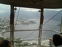
Tenjō-Yama Park Mt. Kachi Kachi Ropeway
Appearance

The Tenjō-Yama Park Mt. Kachi Kachi Ropeway (天上山公園カチカチ山ロープウェイ, Tenjōyama Kōen Kachikachiyama Rōpuwei), officially the Lake Kawaguchi Mt. Tenjō Ropeway (河口湖天上山ロープウェイ, Kawaguchiko Tenjōyama Rōpuwei), is a Japanese aerial lift line in Fujikawaguchiko, Yamanashi, operated by Fuji Kyuko. Opened in 1959, the line climbs Mount Tenjō from the shores of Lake Kawaguchi, one of the Fuji Five Lakes. The line name comes from Kachi-kachi Yama (lit. "Mt. Kachikachi"), a folktale which took place on the mountain. The observatory has a view of the lake, as well as Aokigahara forest, and Mount Fuji.
Basic data
[edit]- System: Aerial tramway, 3 cables
- Cable length: 460 m (1,509 ft)
- Vertical interval: 219 m (719 ft)
- Maximum gradient: 34°07′
- Operational speed: 3.4 m/s
- Passenger capacity per a cabin: 36
- Cabins: 2
- Stations: 2
- Duration of one-way trip: 3 minutes
See also
[edit]External links
[edit]- Official website (in Japanese)
35°30′13.7″N 138°46′27.1″E / 35.503806°N 138.774194°E


