
Teror
This article needs additional citations for verification. (April 2014) |
Teror | |
|---|---|
Municipality | |
 Calle Real, Teror | |
 Flag .svg) Coat of arms | |
 Municipal location in Gran Canaria | |
 Teror Location in the province of Las Palmas  Teror Teror (Canary Islands)  Teror Teror (Spain, Canary Islands) | |
| Coordinates: 28°3′32″N 15°32′51″W / 28.05889°N 15.54750°W | |
| Country | Spain |
| Autonomous Region | Canary Islands |
| Province | Las Palmas |
| Island | Gran Canaria |
| Government | |
| • Mayor | Pedro Manuel Rodríguez Pérez (CC) |
| Area | |
| • Total | 25.70 km2 (9.92 sq mi) |
| Elevation (AMSL) | 543 m (1,781 ft) |
| Population (2018)[2] | |
| • Total | 12,449 |
| • Density | 480/km2 (1,300/sq mi) |
| Time zone | UTC+0 (CET) |
| • Summer (DST) | UTC+1 (CEST (GMT +1)) |
| Postal code | 35330 |
| Area code | +34 (Spain) + 928 (Las Palmas) |
| Website | www.teror.es |
Teror is a town and a municipality in the northern part of the island of Gran Canaria in the Province of Las Palmas in the Canary Islands. Its population is 12,671 (2013),[3] and the town area is 25.70 km2.[1] Teror is situated in the mountains, 14 km southwest of Las Palmas city. September 8 is the local festivity celebrating Virgen del Pino (virgin of the pine, patron of the Gran Canaria).[4]
Teror has a well preserved old town centre, which is under monument protection. There is a basilica, the quiet Virgin of the Pine Square in front of it, and neatly fronted buildings along the picturesque Calle Real de la Plaza street. After shepherds witnessed a Marian apparition nearby on 8 September 1481, Teror became the most important pilgrimage destination of Gran Canaria, and, as a result, rather prosperous. White houses with wooden balconies, where many of the island’s older families congregated, are typical of the town.
Mineral water is an important product of Teror. There's a weekly market (mercadillo) on Sundays.
-
 Basilika "Nuestra Señora del Pino"
 -
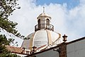 Cupola of the Basílica de Nuestra Señora del Pino
 -
 Townhall
 -
 Facade, Calle Real de la Plaza
 -
 Facade, Calle Real de la Plaza
 -
 Facade, Calle Real de la Plaza
 -
 Balcony Calle Real de la Plaza 15
 -
 Water steps
 -
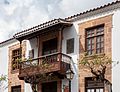
 Typically Spanish Teror balcony
 -
 Main street to Basílica de Nuestra Señora del Pino
 -
 Backside of Basílica de Nuestra Señora del Pino
 -
 Conspicuous corner tavern with balcony
 -
 Town square in front of Basílica de Nuestra Señora del Pino
 -
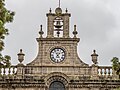 Top of Basilika "Nuestra Señora del Pino"
 -
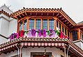 Facade with flower decor
.jpg)


.jpg)
.jpg)
.jpg)
.jpg)
.jpg)
.jpg)
See also[edit]
References[edit]
- ^ a b Instituto Canario de Estadística, area
- ^ Municipal Register of Spain 2018. National Statistics Institute.
- ^ Instituto Canario de Estadística, population
- ^ Nuestra Señora del Pino (in Spanish) Website of the Servants of the Pierced Hearts of Jesus and Mary
External links[edit]
Places adjacent to Teror | |
|---|---|
| Governance |   | ||||||||
|---|---|---|---|---|---|---|---|---|---|
| Municipalities | |||||||||
| History | |||||||||
| Nature | |||||||||
| Landmarks and attractions |
| ||||||||
| Transport |
| ||||||||
| Sport | |||||||||
| Education and science | |||||||||
| International | |
|---|---|
| National | |
| Geographic | |