
Agaete
Agaete | |
|---|---|
 Puerto de las Nieves (Port of the Snows) | |
 Flag  Coat of arms | |
| Nickname: culeto | |
 Agaete municipality in Gran Canaria | |
 Agaete Location in the province of Las Palmas  Agaete Agaete (Canary Islands)  Agaete Agaete (Spain, Canary Islands) | |
| Coordinates: 28°6′N 15°42′W / 28.100°N 15.700°W | |
| Country | |
| Autonomous Region | Canary Islands |
| Province | Las Palmas |
| Island | Gran Canaria |
| Government | |
| Area | |
| • Total | 45.50 km2 (17.57 sq mi) |
| Elevation | 43 m (141 ft) |
| Population (2018)[2] | |
| • Total | 5,573 |
| • Density | 120/km2 (320/sq mi) |
| Time zone | UTC+0 (GMT) |
| Climate | BWh |
| Website | Ayuntamiento de Agaete |
Agaete is a municipality of Las Palmas province, on the Canary Islands, Spain.
Geography
[edit]It is in the north-west of Gran Canaria island, and is enclosed by the Atlantic Ocean to the west, Gáldar to the north-east, and Artenara to the south. Agaete's area is 45.50 km2 (17.57 sq mi)[1] with a population of 5,796 (2003).[3]
Tourism
[edit]The port of Agaete, Puerto de las Nieves, used to be the preferred place to get a view of El Dedo de Dios, a natural monument on the coastline, before the latter was destroyed during tropical storm Delta in November 2005. The port is a common end point for day tours from more touristic areas of the island.
Archaeology
[edit]El Maipes necropolis is on the outskirts of the town, in the south-east near the football ground.
Gallery
[edit]-
 Church of Conception
 -
 Monument Huerto de las Flores
(the Flowers Garden) -
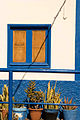 Colours in Agaete
 -
 Windmill in Agaete
 -
 Statue of Los tres poetas in Puerto de las Nieves
 -
 Ferry connections from Agaete to western Canary Islands
 -
 Puerto de las Nieves
 -
 Puerto de las Nieves seen from the Tamadaba mountain
 -
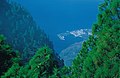
 Barranco de Agaete
 -
 Agaete valley
(Valle de Agaete)


.jpg)
.jpg)


See also
[edit]References
[edit]- ^ a b Instituto Canario de Estadística, area
- ^ Municipal Register of Spain 2018. National Statistics Institute.
- ^ Instituto Canario de Estadística Archived April 23, 2014, at the Wayback Machine, population
External links
[edit]Wikimedia Commons has media related to Agaete.
- Ayuntamiento de Agaete
- Photos of Agaete, including Puerto de Las Nieves and the valley, "El Valle"
Places adjacent to Agaete | ||||||||||||||||
|---|---|---|---|---|---|---|---|---|---|---|---|---|---|---|---|---|
| ||||||||||||||||
| Governance |   | ||||||||
|---|---|---|---|---|---|---|---|---|---|
| Municipalities | |||||||||
| History | |||||||||
| Nature | |||||||||
| Landmarks and attractions |
| ||||||||
| Transport |
| ||||||||
| Sport | |||||||||
| Education and science | |||||||||
| International | |
|---|---|
| National | |