
Zaragoza, Nueva Ecija
Zaragoza | |
|---|---|
| Municipality of Zaragoza | |
 Downtown | |
 Flag  Seal | |
 Map of Nueva Ecija with Zaragoza highlighted | |
OpenStreetMap  | |
.svg) Zaragoza Location within the Philippines | |
| Coordinates: 15°26′57″N 120°47′36″E / 15.4492°N 120.7933°E | |
| Country | Philippines |
| Region | Central Luzon |
| Province | Nueva Ecija |
| District | 1st district |
| Named for | Zaragoza, Aragon, Spain |
| Barangays | 19 (see Barangays) |
| Government | |
| • Type | Sangguniang Bayan |
| • Mayor | Efren O. Nieves |
| • Vice Mayor | Edwin A. Buendia |
| • Representative | Estrellita B. Suansing |
| • Municipal Council | Members |
| • Electorate | 30,881 voters (2022) |
| Area | |
| • Total | 72.02 km2 (27.81 sq mi) |
| Elevation | 20 m (70 ft) |
| Highest elevation | 34 m (112 ft) |
| Lowest elevation | 14 m (46 ft) |
| Population (2020 census)[3] | |
| • Total | 53,090 |
| • Density | 740/km2 (1,900/sq mi) |
| • Households | 13,352 |
| Economy | |
| • Income class | 3rd municipal income class |
| • Poverty incidence | 3.82 |
| • Revenue | ₱ 183.1 million (2020) |
| • Assets | ₱ 615.2 million (2020) |
| • Expenditure | ₱ 169.3 million (2020) |
| • Liabilities | ₱ 162.7 million (2020) |
| Service provider | |
| • Electricity | Tarlac 2 Electric Cooperative (TARELCO 2) |
| Time zone | UTC+8 (PST) |
| ZIP code | 3110 |
| PSGC | |
| IDD : area code | +63 (0)44 |
| Native languages | Tagalog Ilocano |
Zaragoza, officially the Municipality of Zaragoza (Tagalog: Bayan ng Zaragoza, Ilocano: Ili ti Zaragoza), is a 3rd class municipality in the province of Nueva Ecija, Philippines. According to the 2020 census, it has a population of 53,090 people.[3]
Etymology[edit]
The municipality derived its name from the Zaragoza in Aragon, Spain, out of the colonial past.
History[edit]
Founded in 1878 Zaragoza was born from Bario San Vicente upon recommendation of Don Francisco to Governor Cillos. Zaragoza was a barrio of Aliaga, which was a town of Pampanga; the 1st settlers were Ilocanos & Igorots. Later, Municipal President Cirilo Acosta moved the town hall building to the present site where the Post Office and Comelec extension offices are located. Mayor Pascual Linsangan completed the building. Mayor Francisco Ramirez added the Sangguniang Bayan Session Hall, with Plaza stage, fountain and fenced the site in 1971. Then Mayor Lydia Pagaduan improved the Town Hall in 2010.[5]
Incidents[edit]
On February 17, 2003, Police filed arson and grave threats cases against a local New People's Army (NPA) leader Ka Adrian, team leader of the NPAs Sandatahang Yunit Propaganda, and 5 other members of the Tarlac Provincial Party Committee with the Zaragoza Municipal Trial Court for the January 2003 attack on the Globe Telecom cell-site.[6]
On April 11, 2012, 3 bodies of family members, Pastor Fernandito de Guzman, his wife Rosalinda and 21-year-old son Norie were discovered in Barangay Mayamot, Zaragoza, Nueva Ecija on Wednesday morning. De Guzman was abducted by 3 armed men allegedly being National Bureau of Investigation (NBI) agents.[7]
On May 19, 2012, retired police and former municipal councilor, Napoleon Paraton, 48, was gunned down by 2 armed men at Barangay Santo Rosario Old, Zaragoza, Nueva Ecija.[8][9]
July 30, 2012, the 64-kilometer Central Luzon Expressway (CLEx), from the Hacienda Luisita interchange of the Subic–Clark–Tarlac Expressway (SCTEx) in Tarlac City to San Jose City in Nueva Ecija will be built in 2 phases. It will benefit Zaragoza for it will pass through parts of Tarlac City and La Paz town in Tarlac to Zaragoza, inter alia.[10]
On Saturday, December 23, 2012, Nila Mactal, 62, the high school principal of Zaragoza National High School in Zaragoza town was shot and killed by a lone gunman at her Aliaga, Nueva Ecija house.[11][12][13]
On June 10, 2018, a month before his 44th birthday, Fr Richmond Nilo, 43, a Catholic priest who was serving as parish priest of the St Vincent Ferrer Catholic Church, was shot and killed in the Nuestra Senora de las Nieve chapel in Barangay Mayamot.
Geography[edit]
Zaragoza is located at the southern edge of Nueva Ecija bordering the town of La Paz, Tarlac which, due to its proximity, is more closely economically coherent with each other. The newly opened Subic–Clark–Tarlac Expressway (SCTEX) ends up in La Paz where it connects to the Santa Rosa-Tarlac Road passing through Zaragoza and Santa Rosa going to Cabanatuan and on to the Pan-Philippine Highway to Tuguegarao, Cagayan.
Zaragoza is bounded by the municipalities of San Antonio and Jaen to the south, Santa Rosa to its east, Aliaga and Licab to the north and La Paz, Tarlac is located west. It is 25 kilometres (16 mi) from Cabanatuan, 39 kilometres (24 mi) from Palayan, and 123 kilometres (76 mi) from Manila.
Barangays[edit]
Zaragoza is politically subdivided into 19 barangays. Each barangay consists of puroks and some have sitios.
- Batitang
- Carmen
- Concepcion
- Del Pilar
- General Luna
- H. Romero
- Macarse
- Manaol
- Mayamot
- Pantoc
- San Vicente (Poblacion)
- San Isidro
- San Rafael
- Santa Cruz
- Santa Lucia Old
- Santa Lucia Young
- Santo Rosario Old (Valdez matanda)
- Santo Rosario Young (Valdez bata)
- Valeriana
Climate[edit]
| Climate data for Zaragoza, Nueva Ecija | |||||||||||||
|---|---|---|---|---|---|---|---|---|---|---|---|---|---|
| Month | Jan | Feb | Mar | Apr | May | Jun | Jul | Aug | Sep | Oct | Nov | Dec | Year |
| Mean daily maximum °C (°F) | 28 (82) |
30 (86) |
31 (88) |
33 (91) |
33 (91) |
31 (88) |
30 (86) |
29 (84) |
29 (84) |
30 (86) |
30 (86) |
29 (84) |
30 (86) |
| Mean daily minimum °C (°F) | 20 (68) |
20 (68) |
20 (68) |
22 (72) |
24 (75) |
24 (75) |
24 (75) |
24 (75) |
24 (75) |
23 (73) |
22 (72) |
21 (70) |
22 (72) |
| Average precipitation mm (inches) | 4 (0.2) |
4 (0.2) |
5 (0.2) |
11 (0.4) |
66 (2.6) |
99 (3.9) |
127 (5.0) |
113 (4.4) |
99 (3.9) |
84 (3.3) |
35 (1.4) |
14 (0.6) |
661 (26.1) |
| Average rainy days | 2.2 | 1.9 | 3.2 | 5.3 | 16.1 | 20.8 | 23.5 | 22.8 | 22.2 | 16.5 | 8.9 | 3.5 | 146.9 |
| Source: Meteoblue[14] | |||||||||||||
Demographics[edit]
|
| |||||||||||||||||||||||||||||||||||||||||||||||||||
| Source: Philippine Statistics Authority[15][16][17][18] | ||||||||||||||||||||||||||||||||||||||||||||||||||||
Economy[edit]
Poverty Incidence of Zaragoza
5
10
15
20
25
30
2006
20.20 2009
19.31 2012
18.24 2015
13.20 2018
3.82 2021
11.24 Source: Philippine Statistics Authority[19][20][21][22][23][24][25][26] |
Zaragoza is an agricultural municipality in Nueva Ecija. It is located in Western part of Nueva Ecija bounded with the municipality of La Paz in Tarlac. The main economic resource of the people of Zaragoza is mainly agricultural and rice production. Duck-raising is also a notable industry. The town's public market is also the main center of commerce for a number of barangays in the neighbouring towns.
Status of economic performance boost rapidly due to commercialization and services. More investors and businesses opened that provide their constituent an opportunity to generate jobs. Zaragoza is also the center for financing and banking purposes; basic needed not only for their community, but also to their neighboring towns of Licab, Aliaga and Quezon in Nueva Ecija and La Paz in Tarlac province.
Government[edit]
Local government[edit]
Pursuant to the Local government in the Philippines,[27][28] the political seat of the municipal government is located at the Municipal Town Hall. In the History of the Philippines (1521–1898), the Gobernadorcillo is the Chief Executive who holds office in the Presidencia. During the American rule (1898–1946) (History of the Philippines (1898-1946)), the elected Mayor and local officials, including the appointed ones hold office at the Municipal Town Hall. The legislative and executive departments are vested in the Sangguniang Bayan (Session Hall) and Municipal Trial Court, located in the Town Hall.
Zaragoza's incumbent Mayor is Efren O. Nieves and the Vice Mayor Edwin A. Buendia[29]
Tourism[edit]
Zaragoza's main attractions are: the Welcome arch, the scenic rice fields, the Town Hall, the Monument of Zaragoza Heroes, Don Cirilo B. Acosta Elementary School and the St. Vincent Ferrer Parish Church, initially constructed in 1849.
St. Vincent Ferrer Parish Church[edit]

The 1849 St. Vincent Ferrer Parish Church belongs to the Roman Catholic Diocese of Cabanatuan (Dioecesis of Cabanatuanensi, Suffragan of Lingayen-Dagupan, comprising 16 towns of Southern Nueva Ecija, Cabanatuan, Palayan City and Gapan; Titular: St. Nicholas of Tolentine, September 10; Most Reverend Sofronio A. Bancud, SSS, DD, located at Poblacion, Zaragoza, 3110 Nueva Ecija; Titular: St. Vincent Ferrer, Feast is April 5).
Its Parish Priest is Fr. Nezelle O. Lirio.[30][31] Priests in Residence include Rev. Fr. Joseph B. Azarcon (School Director)Feast, The Feast day is April 5.[32][33]
On December 30, 2000, the renovated and rehabilitated Church facade, belfry, baptismal font, vestry, Rectory, Room of the Saints by were blessed by Bishop Sofio Guinto Balce † (11 Nov 1990 Succeeded - 25 Jun 2004 Died).
Saint Vincent Ferrer (23 January 1350 – 5 April 1419) was a Valencian Dominican friar, who gained acclaim as a missionary and a logician. He is honored as a saint of the Catholic Church.
Gallery[edit]
-
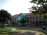 Town Hall
 -
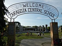 Zaragoza Central School
 -
 Junction, Crossing
 -
 Public market


References[edit]
- ^ Municipality of Zaragoza | (DILG)
- ^ "2015 Census of Population, Report No. 3 – Population, Land Area, and Population Density" (PDF). Philippine Statistics Authority. Quezon City, Philippines. August 2016. ISSN 0117-1453. Archived (PDF) from the original on May 25, 2021. Retrieved July 16, 2021.
- ^ a b Census of Population (2020). "Region III (Central Luzon)". Total Population by Province, City, Municipality and Barangay. Philippine Statistics Authority. Retrieved 8 July 2021.
- ^ "PSA Releases the 2018 Municipal and City Level Poverty Estimates". Philippine Statistics Authority. 15 December 2021. Retrieved 22 January 2022.
- ^ File:ZaragozaNuevaEcijajf2254 10.JPG
- ^ "Six rebels charged for attack on Nueva Ecija cellsite | Nation, News, the Philippine Star | philstar.com". The Philippine Star. Archived from the original on 2016-03-04. Retrieved 2013-01-12.
- ^ "Family shot dead in Nueva Ecija". ABS-CBN News.
- ^ "Ex-police pinatay habang nagbibisikleta - Remate". Archived from the original on 2016-03-03. Retrieved 2013-01-12.
- ^ Elona, Jamie. "Suspected gun-for-hire arrested in Nueva Ecija". Philippine Daily Inquirer.
- ^ Roque, Anselmo. "New expressway to benefit Nueva Ecija motorists". Philippine Daily Inquirer.
- ^ "A family reunion | Opinion, News, the Philippine Star | philstar.com". The Philippine Star. Archived from the original on 2017-03-02. Retrieved 2013-01-12.
- ^ Roque, Anselmo. "Purisima tells policemen: Knock on doors, ask why 530,000 guns not licensed". Philippine Daily Inquirer.
- ^ "Official Website of Department of the Interior and Local Government - Kagawaran ng Interyor at Pamahalaang Lokal - Central Luzon Office - DILG R-3 Top Management Reviews First Semester Performance for 2012". Archived from the original on 2015-04-11. Retrieved 2013-01-12.
- ^ "Zaragoza: Average Temperatures and Rainfall". Meteoblue. Retrieved 4 May 2020.
- ^ Census of Population (2015). "Region III (Central Luzon)". Total Population by Province, City, Municipality and Barangay. Philippine Statistics Authority. Retrieved 20 June 2016.
- ^ Census of Population and Housing (2010). "Region III (Central Luzon)" (PDF). Total Population by Province, City, Municipality and Barangay. National Statistics Office. Retrieved 29 June 2016.
- ^ Censuses of Population (1903–2007). "Region III (Central Luzon)". Table 1. Population Enumerated in Various Censuses by Province/Highly Urbanized City: 1903 to 2007. National Statistics Office.
{{cite encyclopedia}}: CS1 maint: numeric names: authors list (link) - ^ "Province of Nueva Ecija". Municipality Population Data. Local Water Utilities Administration Research Division. Retrieved 17 December 2016.
- ^ "Poverty incidence (PI):". Philippine Statistics Authority. Retrieved December 28, 2020.
- ^ "Estimation of Local Poverty in the Philippines" (PDF). Philippine Statistics Authority. 29 November 2005.
- ^ "2003 City and Municipal Level Poverty Estimates" (PDF). Philippine Statistics Authority. 23 March 2009.
- ^ "City and Municipal Level Poverty Estimates; 2006 and 2009" (PDF). Philippine Statistics Authority. 3 August 2012.
- ^ "2012 Municipal and City Level Poverty Estimates" (PDF). Philippine Statistics Authority. 31 May 2016.
- ^ "Municipal and City Level Small Area Poverty Estimates; 2009, 2012 and 2015". Philippine Statistics Authority. 10 July 2019.
- ^ "PSA Releases the 2018 Municipal and City Level Poverty Estimates". Philippine Statistics Authority. 15 December 2021. Retrieved 22 January 2022.
- ^ "PSA Releases the 2021 City and Municipal Level Poverty Estimates". Philippine Statistics Authority. 2 April 2024. Retrieved 28 April 2024.
- ^ "Philippines : Gov.Ph : About the Philippines". www.gov.ph. Archived from the original on January 22, 2009. Retrieved 2009-03-28.
- ^ Firm, Joselito Guianan Chan, Managing Partner, Chan Robles and Associates Law. "THE LOCAL GOVERNMENT CODE OF THE PHILIPPINES - CHAN ROBLES VIRTUAL LAW LIBRARY". www.chanrobles.com.
{{cite web}}: CS1 maint: multiple names: authors list (link) - ^ "2013 Candidates in Zaragoza | List of Candidates for Zaragoza, Nueva Ecija | Know Your Candidates". Archived from the original on 2016-08-16. Retrieved 2013-01-12.
- ^ Inc., CompBiz. "St. Vincent Ferrer at 3110 Nueva Ecija, Zaragoza, Nueva Ecija Philippines". www.thecatholicdirectory.com.
{{cite web}}:|last=has generic name (help) - ^ "Vicariate of St. Rose of Lima | Unto Greater Service : The official Website of the Diocese of Cabanatuan". www.dioceseofcabanatuan.com. Archived from the original on 15 February 2013. Retrieved 6 June 2022.
- ^ http://www.claretianpublications.com/index.php/diocese/20-diocese-of-cabanatuan[dead link]
- ^ http://www.dioceseofcabanatuan.com/st-vincent[permanent dead link]
External links[edit]
- Philippine Standard Geographic Code
- Philippine Census Information
- Local Governance Performance Management System
Places adjacent to Zaragoza, Nueva Ecija | ||||||||||||||||
|---|---|---|---|---|---|---|---|---|---|---|---|---|---|---|---|---|
| ||||||||||||||||
| Municipalities | |
|---|---|
| Component cities | |