Parry Sound: Difference between revisions
Appearance
Content deleted Content added
Tom.Reding (talk | contribs) m +{{Authority control}} (2 IDs from Wikidata), WP:GenFixes on |
page moved |
||
| (3 intermediate revisions by 3 users not shown) | |||
| Line 44: | Line 44: | ||
}} |
}} |
||
'''Parry Sound''' is a [[Sound (geography)|sound or bay]] of [[Georgian Bay]] on [[Lake Huron]], in [[Ontario]], Canada.<ref name="CGNDB" /> It is highly irregularly shaped with many deep bays and islands. [[Killbear Provincial Park]] is located on the large peninsula that separates the sound from Georgian Bay, while it is bordered on the south side by Parry Island, home of the [[Wasauksing First Nation]]. At the head of the sound is the [[Parry Sound, Ontario|namesake town]] that is the largest community on the shores of Georgian Bay from Severn Sound to [[Manitoulin Island]]. |
'''Parry Sound''' is a [[Sound (geography)|sound or bay]] of [[Georgian Bay]] on [[Lake Huron]], in [[Ontario]], Canada.<ref name="CGNDB" /> It is highly irregularly shaped with many deep bays and islands. [[Killbear Provincial Park]] is located on the large peninsula that separates the sound from Georgian Bay, while it is bordered on the south side by Parry Island, home of the [[Wasauksing First Nation]], Wasauksing being the First Nation's name for the bay. At the head of the sound is the [[Parry Sound, Ontario|namesake town]] that is the largest community on the shores of Georgian Bay from Severn Sound to [[Manitoulin Island]]. |
||
The following entities are named after this geographic feature: |
The following entities are named after this geographic feature: |
||
| Line 52: | Line 52: | ||
** [[Parry Sound, Unorganized, North East Part, Ontario]] |
** [[Parry Sound, Unorganized, North East Part, Ontario]] |
||
* Electoral districts |
* Electoral districts |
||
** [[Parry Sound (electoral district)]], the federal electoral district from 1904 to 1949 |
** [[Parry Sound (federal electoral district)]], the federal electoral district from 1904 to 1949 |
||
** [[Parry Sound—Muskoka]], the current federal electoral district |
** [[Parry Sound—Muskoka (federal electoral district)|Parry Sound-Muskoka]], the current federal electoral district |
||
** [[Parry Sound—Muskoka (provincial electoral district)]], the current provincial electoral district |
** [[Parry Sound—Muskoka (provincial electoral district)]], the current provincial electoral district |
||
| Line 59: | Line 59: | ||
==References== |
==References== |
||
[[File:Aerial View of Parry Sound (5432193255).jpg|thumb|right|Aerial View of Parry Sound in 2010]] |
|||
{{Reflist}} |
{{Reflist}} |
||
{{Refbegin}} |
{{Refbegin}} |
||
Latest revision as of 20:55, 6 January 2024
| Parry Sound | |
|---|---|
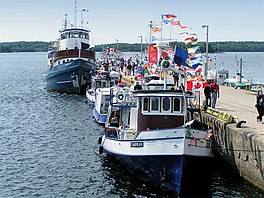
 Harbour of the town of Parry Sound | |
| Coordinates | 45°21′31″N 80°07′12″W / 45.35861°N 80.12000°W[1] |
| Type | Sound |
| Part of | Great Lakes Basin |
| Primary inflows | Seguin River |
| Primary outflows | to Georgian Bay |
| Basin countries | Canada |
| Surface elevation | 176 metres (577 ft)[2] |
Parry Sound is a sound or bay of Georgian Bay on Lake Huron, in Ontario, Canada.[1] It is highly irregularly shaped with many deep bays and islands. Killbear Provincial Park is located on the large peninsula that separates the sound from Georgian Bay, while it is bordered on the south side by Parry Island, home of the Wasauksing First Nation, Wasauksing being the First Nation's name for the bay. At the head of the sound is the namesake town that is the largest community on the shores of Georgian Bay from Severn Sound to Manitoulin Island.
The following entities are named after this geographic feature:
- Parry Sound District
- Parry Sound, town and seat of Parry Sound District
- Parry Sound, Unorganized, Centre Part, Ontario
- Parry Sound, Unorganized, North East Part, Ontario
- Electoral districts
- Parry Sound (federal electoral district), the federal electoral district from 1904 to 1949
- Parry Sound-Muskoka, the current federal electoral district
- Parry Sound—Muskoka (provincial electoral district), the current provincial electoral district

References
[edit]
- ^ a b "Parry Sound". Geographical Names Data Base. Natural Resources Canada. Retrieved 2014-07-31.
- ^ Elevation of Lake Huron
Other map sources:
- Map 8 (PDF) (Map). 1 : 700,000. Official road map of Ontario. Ministry of Transportation of Ontario. 2014. Retrieved 2014-07-31.
External links
[edit]![]() Media related to Parry Sound (bay) at Wikimedia Commons
Media related to Parry Sound (bay) at Wikimedia Commons


