
List of Bermuda hurricanes: Difference between revisions
Juliancolton (talk | contribs) +Alex |
changing dead link to a general citation, info verified prior to it dead linking |
||
| Line 1: | Line 1: | ||
[[File:Bermuda hurricane landfalls map.png|thumb|right|300px|Map depicting the paths of all [[landfall]]ing tropical cyclones, according to the [[Saffir–Simpson hurricane wind scale]], in the territory since 1851]] |
[[File:Bermuda hurricane landfalls map.png|thumb|right|300px|Map depicting the paths of all [[landfall]]ing tropical cyclones, according to the [[Saffir–Simpson hurricane wind scale]], in the territory since 1851]] |
||
The '''list of Bermuda hurricanes''' chronicles [[Atlantic hurricane|Atlantic tropical cyclones]] that have, to some extent, impacted the [[British Overseas Territory]] of [[Bermuda]]. Bermuda is a small [[archipelago]], with 181 islands and islets occupying about {{convert|21|sqmi|sqkm}} in the North Atlantic Ocean, roughly {{convert|650|mi|km}} east of [[Cape Hatteras, North Carolina]].<ref>{{cite web|author=Terence Gallagher|title=Bermuda fact sheet|publisher=Bermuda Tourism Authority|accessdate=December 2, 2015|url=http://www.gotobermuda.com/uploadedFiles/ForThePress/PressKits/Bermuda%20Fact%20Sheet%202011(1).pdf|display-authors=etal}}</ref> Bermuda has a [[humid subtropical climate]]. The islands are situated far outside the main development region for Atlantic hurricanes,<ref name="elsner233">Elsner and Kara, p. 233</ref> but within the belt of recurving tropical cyclones.<ref name="list"/> Most storms form in the central Atlantic or western Caribbean Sea before approaching Bermuda from the southwest; storms forming north of 28°N are unlikely to impact the territory.<ref name="elsner234">Elsner and Kara, p. 234</ref> |
The '''list of Bermuda hurricanes''' chronicles [[Atlantic hurricane|Atlantic tropical cyclones]] that have, to some extent, impacted the [[British Overseas Territory]] of [[Bermuda]]. Bermuda is a small [[archipelago]], with 181 islands and islets occupying about {{convert|21|sqmi|sqkm}} in the North Atlantic Ocean, roughly {{convert|650|mi|km}} east of [[Cape Hatteras, North Carolina]].<ref>{{cite web|author=Terence Gallagher|title=Bermuda fact sheet|publisher=Bermuda Tourism Authority|accessdate=December 2, 2015|url=http://www.gotobermuda.com/uploadedFiles/ForThePress/PressKits/Bermuda%20Fact%20Sheet%202011(1).pdf|display-authors=etal}}</ref> Bermuda has a [[humid subtropical climate]]. The islands are situated far outside the main development region for Atlantic hurricanes,<ref name="elsner233">Elsner and Kara, p. 233</ref> but within the belt of recurving tropical cyclones.<ref name="list">{{citation|author=Mark Guishard, James Dodgson, and Michael Johnston|date=May 2015|title=Hurricanes - General Information for Bermuda|publisher=Bermuda Weather Service}}</ref> Most storms form in the central Atlantic or western Caribbean Sea before approaching Bermuda from the southwest; storms forming north of 28°N are unlikely to impact the territory.<ref name="elsner234">Elsner and Kara, p. 234</ref> |
||
According to the [[Bermuda Weather Service]], the islands of Bermuda experience a damaging tropical cyclone once every six to seven years, on average.<ref name="list"/> Due to the small area of the island chain, [[landfall]]s and direct hits are rare.<ref name="list"/> Strictly speaking, only nine landfalls have occurred during years included in the official [[HURDAT|Atlantic hurricane database]].{{hurdat}} When hurricanes [[Hurricane Fay (2014)|Fay]] and [[Hurricane Gonzalo|Gonzalo]] struck Bermuda just days apart in October 2014, that season became the first to produce two landfalls. Two damaging storms impacted Bermuda in September 1899, but the center of the first storm narrowly missed the islands.<ref name="gonzalotcr"/> Tropical cyclones, and their antecedent or remnant weather systems, have affected the territory in all seasons, most frequently in the late summer months.<ref name="list"/> A study of recorded storms from 1609 to 1996 found that direct hits from hurricanes were most common in early September and late October, with an intervening relative lull creating two distinct 'seasons'.<ref name="elsner236"/> |
According to the [[Bermuda Weather Service]], the islands of Bermuda experience a damaging tropical cyclone once every six to seven years, on average.<ref name="list"/> Due to the small area of the island chain, [[landfall]]s and direct hits are rare.<ref name="list"/> Strictly speaking, only nine landfalls have occurred during years included in the official [[HURDAT|Atlantic hurricane database]].{{hurdat}} When hurricanes [[Hurricane Fay (2014)|Fay]] and [[Hurricane Gonzalo|Gonzalo]] struck Bermuda just days apart in October 2014, that season became the first to produce two landfalls. Two damaging storms impacted Bermuda in September 1899, but the center of the first storm narrowly missed the islands.<ref name="gonzalotcr"/> Tropical cyclones, and their antecedent or remnant weather systems, have affected the territory in all seasons, most frequently in the late summer months.<ref name="list"/> A study of recorded storms from 1609 to 1996 found that direct hits from hurricanes were most common in early September and late October, with an intervening relative lull creating two distinct 'seasons'.<ref name="elsner236"/> |
||
| Line 208: | Line 208: | ||
*April 18–21, 2003 – [[Tropical Storm Ana (2003)|Subtropical Storm Ana]] develops west of Bermuda before slowly looping around to the south as a fully tropical cyclone. The island experiences gusty winds and heavy showers.<ref>{{cite web|date=May 5, 2003|title=Weather Summary for April 2003|publisher=Bermuda Weather Service|accessdate=October 9, 2015|url=http://www.weather.bm/data/2003-04.html|archiveurl=https://web.archive.org/web/20120208144954/http://www.weather.bm/data/2003-04.html|archivedate=2012-02-08}}</ref> |
*April 18–21, 2003 – [[Tropical Storm Ana (2003)|Subtropical Storm Ana]] develops west of Bermuda before slowly looping around to the south as a fully tropical cyclone. The island experiences gusty winds and heavy showers.<ref>{{cite web|date=May 5, 2003|title=Weather Summary for April 2003|publisher=Bermuda Weather Service|accessdate=October 9, 2015|url=http://www.weather.bm/data/2003-04.html|archiveurl=https://web.archive.org/web/20120208144954/http://www.weather.bm/data/2003-04.html|archivedate=2012-02-08}}</ref> |
||
[[File:BDA Fabian damage3.jpg|right|thumb|A road at [[Bermuda International Airport]] washed out by [[Hurricane Fabian]] in September 2003]] |
[[File:BDA Fabian damage3.jpg|right|thumb|A road at [[Bermuda International Airport]] washed out by [[Hurricane Fabian]] in September 2003]] |
||
*September 5, 2003 – The island enters the eastern eyewall of Category 3 [[Hurricane Fabian]], the most destructive hurricane in the territory since 1926.<ref name="fabiantcr">{{cite web|author=Richard Pasch, Eric Blake, and Daniel Brown|title=Hurricane Fabian Tropical Cyclone Report|date=November 19, 2003|publisher=National Hurricane Center|accessdate=October 9, 2015|url=http://www.nhc.noaa.gov/data/tcr/AL102003_Fabian.pdf}}</ref> Elevated stations record wind gusts in excess of {{convert|150|mph|km/h|abbr=on}}, while the south shore is subjected to {{convert|20|to|30|ft|m|abbr=on}} waves and an estimated {{convert|10|ft|m|abbr=on}} [[storm surge]].<ref name="fabiantcr"/> Seawater inundates beachfront structures and compromises the Causeway,<ref name="slideshow">{{cite web|title=Hurricane Fabian slideshow|publisher=Bermuda Weather Service|accessdate=November 3, 2015|url=http://www.weather.bm/TropicalArchive/fabian/fabian_slideshow.html}}</ref> where four people are swept away in their vehicles. Fabian produces considerable damage to property and vegetation, unroofing some buildings in exposed locations and causing more severe failures in weaker structures.<ref name="fabiantcr"/> The wind damage is possibly exacerbated by several small tornadoes reportedly embedded in the hurricane's eyewall.<ref name="slideshow"/> About 25,000 electric customers lose power,<ref name="rg"/> and total damage exceeds $300 million.<ref name="fabiantcr"/> Fabian is the only tropical cyclone in the [[weather satellite]] era to directly cause fatalities on Bermuda.<ref name="list" |
*September 5, 2003 – The island enters the eastern eyewall of Category 3 [[Hurricane Fabian]], the most destructive hurricane in the territory since 1926.<ref name="fabiantcr">{{cite web|author=Richard Pasch, Eric Blake, and Daniel Brown|title=Hurricane Fabian Tropical Cyclone Report|date=November 19, 2003|publisher=National Hurricane Center|accessdate=October 9, 2015|url=http://www.nhc.noaa.gov/data/tcr/AL102003_Fabian.pdf}}</ref> Elevated stations record wind gusts in excess of {{convert|150|mph|km/h|abbr=on}}, while the south shore is subjected to {{convert|20|to|30|ft|m|abbr=on}} waves and an estimated {{convert|10|ft|m|abbr=on}} [[storm surge]].<ref name="fabiantcr"/> Seawater inundates beachfront structures and compromises the Causeway,<ref name="slideshow">{{cite web|title=Hurricane Fabian slideshow|publisher=Bermuda Weather Service|accessdate=November 3, 2015|url=http://www.weather.bm/TropicalArchive/fabian/fabian_slideshow.html}}</ref> where four people are swept away in their vehicles. Fabian produces considerable damage to property and vegetation, unroofing some buildings in exposed locations and causing more severe failures in weaker structures.<ref name="fabiantcr"/> The wind damage is possibly exacerbated by several small tornadoes reportedly embedded in the hurricane's eyewall.<ref name="slideshow"/> About 25,000 electric customers lose power,<ref name="rg"/> and total damage exceeds $300 million.<ref name="fabiantcr"/> Fabian is the only tropical cyclone in the [[weather satellite]] era to directly cause fatalities on Bermuda.<ref name="list"/> In response to the hurricane's destruction, the name ''Fabian'' is [[list of retired Atlantic hurricanes|retired]] and replaced with ''Fred'' for 2009. |
||
*September 27, 2003 – [[Hurricane Juan]]'s passage to the east is marked by gusty winds.<ref>{{cite web|title=Weather Summary for November 2003|publisher=Bermuda Weather Service|accessdate=November 3, 2015|url=http://www.weather.bm/data/2003-09.html|archiveurl=https://web.archive.org/web/20120205194157/http://www.weather.bm/data/2003-09.html|archivedate=2012-02-05}}</ref> |
*September 27, 2003 – [[Hurricane Juan]]'s passage to the east is marked by gusty winds.<ref>{{cite web|title=Weather Summary for November 2003|publisher=Bermuda Weather Service|accessdate=November 3, 2015|url=http://www.weather.bm/data/2003-09.html|archiveurl=https://web.archive.org/web/20120205194157/http://www.weather.bm/data/2003-09.html|archivedate=2012-02-05}}</ref> |
||
*October 8–10, 2004 – [[Subtropical Storm Nicole (2004)|Subtropical Storm Nicole]] and its precursor disturbance overspread the island with heavy rainfall and winds up to {{convert|60|mph|km/h|abbr=on}}.<ref name="list"/> The system causes minor power outages.<ref>{{cite news|author=Sarah Titterton and Eloisa Mayers|title=Nicole drowns out the music|date=October 11, 2004|newspaper=The Royal Gazette|accessdate=November 3, 2015|url=http://www.royalgazette.com/article/20041011/NEWS/310119988}}</ref> |
*October 8–10, 2004 – [[Subtropical Storm Nicole (2004)|Subtropical Storm Nicole]] and its precursor disturbance overspread the island with heavy rainfall and winds up to {{convert|60|mph|km/h|abbr=on}}.<ref name="list"/> The system causes minor power outages.<ref>{{cite news|author=Sarah Titterton and Eloisa Mayers|title=Nicole drowns out the music|date=October 11, 2004|newspaper=The Royal Gazette|accessdate=November 3, 2015|url=http://www.royalgazette.com/article/20041011/NEWS/310119988}}</ref> |
||
Revision as of 18:09, 18 January 2016

The list of Bermuda hurricanes chronicles Atlantic tropical cyclones that have, to some extent, impacted the British Overseas Territory of Bermuda. Bermuda is a small archipelago, with 181 islands and islets occupying about 21 square miles (54 km2) in the North Atlantic Ocean, roughly 650 miles (1,050 km) east of Cape Hatteras, North Carolina.[1] Bermuda has a humid subtropical climate. The islands are situated far outside the main development region for Atlantic hurricanes,[2] but within the belt of recurving tropical cyclones.[3] Most storms form in the central Atlantic or western Caribbean Sea before approaching Bermuda from the southwest; storms forming north of 28°N are unlikely to impact the territory.[4]
According to the Bermuda Weather Service, the islands of Bermuda experience a damaging tropical cyclone once every six to seven years, on average.[3] Due to the small area of the island chain, landfalls and direct hits are rare.[3] Strictly speaking, only nine landfalls have occurred during years included in the official Atlantic hurricane database.[5] When hurricanes Fay and Gonzalo struck Bermuda just days apart in October 2014, that season became the first to produce two landfalls. Two damaging storms impacted Bermuda in September 1899, but the center of the first storm narrowly missed the islands.[6] Tropical cyclones, and their antecedent or remnant weather systems, have affected the territory in all seasons, most frequently in the late summer months.[3] A study of recorded storms from 1609 to 1996 found that direct hits from hurricanes were most common in early September and late October, with an intervening relative lull creating two distinct 'seasons'.[7]
Hurricanes late in the year are often in the process of undergoing extratropical transition and receiving baroclinic enhancement.[7] Bermuda is less likely to be impacted during years when the Caribbean, Gulf of Mexico, and southeastern United States are favored targets.[3] Even in intense hurricanes, the islands tend to fare relatively well; since a cyclone in 1712 that destroyed many wooden buildings, most structures have been built with stone walls and roofs, and are able to withstand severe winds. As such, hurricane-related deaths are uncommon throughout the history of the territory.[3] Ten storms have collectively caused 129 fatalities; 110 of them, or 85%, were the result of shipwrecks along the shore in Hurricane "Ten" of 1926. Hurricane Fabian in 2003 was the only system in the weather satellite era to cause storm-related deaths.
In total, 178 events are listed, with widely varying degrees of damage. A hurricane in 1609 was responsible for the first permanent settlement on Bermuda: in late July, the Jamestown-bound, British ship Sea Venture nearly foundered in the storm and sought refuge on the islands, which the passengers found surprisingly hospitable. Hurricane Fabian was the most intense storm to impact the territory in modern times, though officially it did not make landfall, and was the only storm to have its name retired for effects in Bermuda. The costliest storms were Fabian and Gonzalo, which caused about $300 million and $200–400 million in damage, respectively (2003 and 2014 USD). Accounting for inflation and continued development, Fabian would have likely wrought around $650 million in damage had it struck in 2014.[8] The most recent storm to affect the islands was Hurricane Joaquin in October 2015.
List of storms
1543–1699
- 1543 – The modern-day Spittal Pond Nature Reserve is the site of a rock on which the year 1543 and indistinct initials were carved, likely by the occupants of a Portuguese vessel that became separated from her fleet and driven aground in the summer months. Thirty sailors survived on Bermuda for about 60 days, during which time they constructed a seaworthy craft from recovered timbers of their wrecked ship. Given the time of year, a tropical hurricane may have been responsible for this incident.[9]
- July 24, 1609 – A hurricane sets the stage for the British colonization of Bermuda when a ship bound for Jamestown, Virginia, is caught in the storm and forced to steer aground. When a fleet of Virginia Company ships tasked with resupplying the failing Jamestown colony encounters the hurricane, the flagship, Sea Venture, becomes separated from the other vessels and begins to take on water. The increasingly waterlogged Sea Venture battles the tremendous seas until July 28, when, just as the crew becomes resigned to their fate, Admiral Sir George Somers spots the uninhabited rocky shores of Bermuda. To prevent the ship from sinking, Somers deliberately drove her onto the reefs about half a mile off the eastern coast. Using the ship's longboat, all 150 settlers, as well as the crew, make it safely ashore.[10] The so-called "Isle of Devils" proved far more hospitable than initially feared, with abundant food and resources. Two new ships, the Deliverance and the Patience, were constructed, and nearly all of the Sea Venture's'' original occupants set sail for Jamestown. The Virginia Company administered the islands until the formation of the Somers Isles Company in 1615.[11] The tale of the Sea Venture inspired William Shakespeare to write The Tempest, and the coat of arms of Bermuda features a prominent representation of the shipwreck.[10]
- July (?) 1612 – A hurricane destroys a recently constructed church.[12]
- September 1615 – A severe hurricane strikes Bermuda [13]
- November 1619 – Two hurricanes strike Bermuda during the month, sinking at least one ship, uprooting large trees, ruining the entire winter corn crop, and destroying a wooden watchtower constructed seven years earlier.[3][14] The rapid succession of two hurricanes left the colony with a severe food shortage.[15]
- 1620 – A hurricane flattens hastily built shacks, while two fishermen are lost at sea.[15]
- September 13, 1621 – The arrival of a supply ship into port is delayed by stormy conditions; by the time the vessel wrecks along the coast, some of her passengers have died of a rampant illness.[16]
- August 16, 1629 – The most damaging hurricane thus far in the colony's history destroys crops, several forts, a prison, and the rebuilt watchtower.[3]
- October 20, 1639 – Two Spanish ships ground out in a hurricane; the occupants are brought ashore, and charged monthly accommodation fees until their departure the following February. The sailors claim that the Governor had prevented them from leaving the colony except by means of purchasing their own ship.[17]
- October 16, 1664 – A British ship blows aground in the midst of a storm.[18]
- August 24, 1669 – One ship is wrecked by a hurricane along the shore of Castle Island, with five men lost, and another capsizes roughly 20 mi (32 km) off Ireland Island.[19]
- 1686 – Hurricane season leaves the Government House in a state of disrepair.[19]
1700–1799
- September 8, 1712 – A severe hurricane buffets Bermuda for eight hours, destroying most of the churches. The storm serves to prove the necessity of ongoing efforts to shift toward stone construction instead of wood.[20]
- 1713 – By November, the effects of two hurricanes were evident, though the impact was less severe than the 1712 hurricane.[20]
- 1715 – A disastrous hurricane destroys all wooden churches left standing after the 1712 hurricane.[20]
- 1726 – A season of stormy weather includes two hurricane strikes in rapid succession. Private and public buildings alike are damaged by the hurricanes, but the chronically stormy weather leads to a stream of stricken ships entering St. George's for repairs. Without the support of the Somers Isles Company, which was dissolved in 1684, impoverished colonists grow disillusioned; they are often unable to repair storm-related damage, the crops in 1726 are a complete loss, and the small supply of gunpowder is compromised.[21]
- 1728 – The newly appointed Governor of Bermuda, John Pitt, arrives to find the island in distress from a recent hurricane impact. The official residence required repair once more.[22]
- October 18, 1780 – After emerging from the Lesser Antilles, where it establishes itself as the deadliest Atlantic hurricane on record, the Great Hurricane of 1780 devastates Bermuda,[3] likely passing southeast of the islands.[23] Some fifty ships are driven ashore with the storm surge, and vast swaths of trees are uprooted; the town of St. George's is left with a "completely denuded air". Many homes are demolished. Famine and a smallpox epidemic take hold in the aftermath of the hurricane.[24]
- September 1786 – Houses are damaged and trees are uprooted by a hurricane, and the cotton crop is largely destroyed.[25]
- October 23, 1793 – A violent hurricane passes near the islands, causing "inconceivable" damage to homes and public buildings, many of them being totally destroyed. The storm topples several thousand trees and wreaks havoc on shipping; every vessel in St. George's Harbour is driven aground, many ships being wrecked or heavily damaged, and numerous wharves are lost. Most of the 40 or so fish ponds along the north shore of St. David's Island, with a cumulative capacity of about 5,000 fish, are destroyed.[26]
1800–1849
- September 9–10, 1800 – The sloop John founders amid rough seas from a tropical storm or hurricane; her entire crew is rescued.[27] Bermuda is subjected to a period of gales but suffers no damage.[3]
- November 4–5, 1800 – A hurricane brings strong winds to the islands, "destroying every shrub in its direction."[27] Damage to trees and crops is substantial, and multiple vessels are driven ashore. This hurricane prompts a change in attitude toward the need for a lighthouse in Bermuda, and the establishment of a Marine Society was sought to aid families of sailors lost along the rocky coasts.[27]
- August 4–5, 1813 – Prior to this storm, St. George's Harbour becomes congested with numerous warships due to a war between Great Britain and the United States. Additionally, the economic aspect of this war leads to merchant vessels being detained within the harbour, further crowding the waters. A complete record of the number of ships does not exist, though at least 30 are believed to be present at the time of the hurricane. Around noon on August 4, a heavy squall affects the islands and winds steadily increase through the night. By early the following morning, winds roared at 90 mph (140 km/h), tearing roofs from homes and ships from their moorings. Described as a "horde of ships" by Master Joseph Hinson of the schooner Chapman, vessels in the crowded harbour violently collide with one another.[28] Nearly every vessel is driven ashore or wrecked. Untold quantities of cargo are lost, with little to salvage. Despite the damage, only one life is lost aboard the ketch General Doyle. In the storm's wake, construction begins on a new breakwater and other coastal installations.[28]
- October 15–19, 1814 – A hurricane strikes the islands "head-on", with persistent gale-force winds. Roads are clogged with debris and some homes are flooded, though damage is generally minor.[3][29]
- 1815 – A slow-moving hurricane on an unspecified date batters the islands, altering the configuration of the coastline.[30]
- August 1818 – A hurricane unroofs the Town Hall building on Front Street in Hamilton.[31]
- September 19, 1828 – A hurricane to the northwest produces gale-force winds.[3]
- June 6–7, 1832 – The center of a tropical cyclone passes over or very close to the islands.[3] Two schooners in St. George's Harbour are driven aground, and several houses are partially or totally unroofed. Tree damage is extensive.[32]
- September 11–12, 1839 – One of the worst storms in Bermuda's history strikes the islands from the south with an exceptional 11 ft (3.4 m) storm surge.[3][33] Boats along the southern shore are carried inland and deposited in fields,[34] while various species of fish are seen hundreds of yards from the coast.[35] Force 12 winds uproot many thousands of trees and level numerous homes; few structures escape damage. Roadways are left impassable by debris from trees, walls, and fences. Many families are left homeless, some forced to abandon their homes in the middle of the night and endure the storm in the open. Sea spray renders nearly all residential wells brackish. Despite the destruction, no lives are reported lost.[36] The storm is typically known as Reid's Hurricane, after the newly appointed Bermuda Governor William Reid who studied and documented Atlantic hurricanes with great interest.[37]
- October 21, 1841 – Hurricane-force winds from a nearby cyclone destroy a couple houses and damage several more, as well as destroying trees and food crops. Potato plants are left "as black and withered as if destroyed by a severe frost".[38]
- August 18, 1843 – A small hurricane is remotely felt in the form of gusty winds.[3]
- October 27, 1845 – The islands experience gale-force winds from a tropical cyclone to the east.[39]
- September 17–18, 1846 – Squally weather and pounding surf indicate the passage of a hurricane to the south and west. Aside from damage to trees, no major destruction is reported.[40]
- October 15, 1848 – Violent winds and tides 3 to 4 feet (0.91 to 1.22 m)* from a nearby hurricane batter the islands. Many wharves are submerged or entirely washed away, while stone walls and part of a breakwater collapse from the force of the surge. Roadways and homes in Flatts Village are also flooded.[41]
1850–1899
- September 6–8, 1853 – The outer fringes of a major hurricane are felt in the islands, but no damage is reported.[42]
- September 26–27, 1853 – A tropical cyclone to the east produces gale-force winds and heavy rainfall.[42]
- October 21, 1854 – A tropical storm passes a short distance to the southeast with Force 11 winds. "Great" property damage is reported, particularly at Spanish Point, and numerous boats are destroyed. Observers witness two possible tornadoes: one that passes over Boaz Island, scouring the ground, and another in eastern Paget Parish that topples trees and unroofs a home.[43]
- October 23–24, 1858 – The center of a moderate hurricane passes near the islands with powerful winds and flooding tides. The storm damages many homes and churches, and uproots a large number of trees.[44]
- October 4, 1866 – Force 11 winds are reported on the outer fringes of a distant hurricane. Buildings sustain roof and wall damage, trees are toppled, and several boats are damaged or wrecked.[45]
- September 10, 1870 – A major hurricane to the northwest blows down a large number of banana trees.[45]

- September 5, 1874 – A hurricane to the west generates huge swells as sea spray defoliates plants across the territory.[46]
- October 20–23, 1876 – Gale-force winds and heavy rainfall mark the passage of a hurricane to the north.[47]
- August 27–28, 1878 – Streets are clogged with fallen trees as a hurricane passes to the north.[48] At the height of a storm, a floating dry dock—the largest ever built at the time[49]—is damaged after breaking from its moorings at HM Dockyard, crushing wharves and a mooring bridge. The dock came to rest on a breakwater.[50]
- August 29–30, 1880 – A slow-moving hurricane hurricane, locally cited as the most severe since 1839, makes its closest approach approximately 40 mi (60 km) to the northeast.[3] Intense winds cause "vast" damage to buildings and vegetation, particularly in eastern parts of the islands. A newly built school is destroyed in Smith's Parish, and the Causeway sustains significant damage.[51][52] Several ships are driven aground, and dozens of smaller boats are wrecked.[52] Fruit crops are a total loss.[53]
- October 14, 1880 – Blustery squalls are reported along the fringe of a hurricane to the southeast.[54]
- August 28, 1891 – Heavy squalls and winds to Force 6 indicate the passage of a hurricane to the east.[55] The storm damages trees, telegraph wires, and stone walls.[56]
- September 19–22, 1891 – A slow-moving Category 2 hurricane approaches from the east and recurves just before the islands. High winds bring down trees and utility wires,[57] and a Spanish brig loaded with lumber wrecks along the southwestern shore.[58]
- October 4, 1891 – A moderate hurricane to the west produces a prolonged period of strong winds and heavy rain,[55] but no appreciable damage is reported.[59]
- October 17–18, 1891 – A hurricane passes a short distance to the west with extremely high tides and pounding waves.[3][55] The Causeway is extensively damaged.[59]
- August 19–20, 1892 – Though winds are relatively light, a hurricane to the west causes some agricultural, structural, and maritime damage.[60]
- October 15, 1882 – Winds just below hurricane force are recorded at the Gibbs Hill Lighthouse as a hurricane passes to the east.[3]
- October 26, 1894 – A fast-moving hurricane to the west delivers a brief period of hurricane-force winds, toppling trees and telephone poles. The storm blows down roofing material and ruins vegetable crops.[61]
- October 24, 1895 – Wind gusts of 120 mph (190 km/h) are reported in association with a direct hit from a moderate hurricane.[3] Dozens of telephone poles are snapped, while "enormous" trees are uprooted. Extensive damage befalls homes, businesses, and public buildings.[62]
- September 4, 1899 – A Category 1 hurricane passes just to the northwest, producing hurricane-force winds and significant damage.[63]
- September 12–13, 1899 – The distinct eye of a Category 3 hurricane tracks over Bermuda, with severe damage reported in many areas.[64] As residents are preoccupied with cleanup efforts from the previous storm, the hurricane catch the islands off-guard.[65] Houses are unroofed or completely destroyed, and large boulders along the southern shore are tossed inland. Wharves and boats are wrecked. HM Dockyard in particular takes heavy losses, amounting to "at least five figures" (GBP).[64] St. George's Parish is cut off from the mainland after the Causeway is demolished by strong waves, at a cost of around £15,000. The hurricane also extensively damages crops and vegetation, dealing a major blow to farmers.[65] Early estimates place total property damage at £100,000.[66]
1900s
- September 17, 1900 – Strong winds from a hurricane to the east cause little damage.[3]
- September 28, 1903 – A Category 2 hurricane passing a short distance to the east causes significant damage. Winds of 74 mph (119 km/h) uproot large numbers of trees, while heavy rainfall washes out roadways. Along the coast, docks, seawalls, and boats are destroyed;[67] hundreds of buildings throughout the islands are damaged.[68] Two fatalities are attributed to the storm: one man drowns at Ireland Island, and another is crushed by a collapsing wall in St. George's.[67]
- September 8–9, 1906 – A major hurricane to the northwest brushes the islands with 70 mph (110 km/h) winds, blowing down roof slates, telephone wires, and trees. One man drowns after being blown off Watford Bridge, and another fatality occurs in Hamilton Harbour as a sailboat capsizes in a severe squall.[69] A ferry in the harbour is destroyed by fire, which briefly threatens to spread to land.[70]
- October 13, 1909 – A dissipating tropical storm produces strong winds.[71]
1910s

- September 25, 1910 – A moderate hurricane to the east damages buildings in St. George's, topples a few banana trees, and blows a ship aground. Heavy rains provide residents with many months of clean drinking water.[71]
- September 3–8, 1915 – A Category 3 hurricane meanders around the islands for several days, during which time gale-force winds blow from nearly all directions.[72] Heavy rains cause many roofs to leak, and overall damage is extensive. Enormous waves from the hurricane wreck many boats; one cargo ship in particular, the SS Pollockshields, is driven aground on a reef off Elbow Beach. The captain drowns while attempting to procure a life jacket for a crew member, but all other men are eventually rescued.[73][74]
- September 23, 1916 – A major hurricane just to the west brings winds of at least 84 mph (135 km/h). The storm, considered the most severe in many years, damages most structures, with several being nearly or completely destroyed. Exposed buildings along Front Street in Hamilton bear the brunt of the hurricane.[75] Numerous small boats in Hamilton Harbour are wrecked.[3]
- September 4, 1917 – Enormous waves and extremely high tides from a major hurricane to the east inundate low-lying areas, including the entirety of Market Square in St. George's; individuals at Town Hall become stranded by the rising waters. A large section of Higgs' Island is swept away.[76]
- September 4–5, 1918 – The center of a Category 2 hurricane passes narrowly to the west, sinking or grounding boats and flooding parts of the islands. Winds of at least 60 mph (100 km/h) topple trees and shatter windows.[77][78]
1920s
- September 15, 1921 – A high-end Category 2 hurricane inflicts severe damage on trees, public utilities, and small boats while striking the island. Many buildings – including several hotels – suffer damage, mostly of a minor nature.[79] Wind gusts as high as 120 mph (190 km/h) are recorded at Prospect Hill before the anemometer is toppled.[72][79] Water wells become contaminated by the sea spray.[79]
- September 21, 1922 – Bermuda is struck by a Category 3 hurricane and associated 8 ft (2.4 m) storm surge, resulting in the highest tide since 1899. The hurricane submerges homes, roads, wharves, and other coastal installations, while 60 ft (18 m) waves break along the south shore. Winds reaching 120 mph (190 km/h) ravage vegetation, particularly banana trees. Heavy structural damage is also reported throughout the territory, and a number of small houses on White's Island are blown into the water.[80] Total damage is estimated at $250,000,[81] and one fatality occurs when a sailor falls overboard at the Dockyard.[80]

- September 23, 1923 – A major hurricane to the northwest brings winds of 62 mph (100 km/h) with gusts to 90 mph (140 km/h).[3] Parts of St. George's are inundated with seawater, and cottages on St. David's Island are damaged. The storm brings down trees, tree branches, and powerlines.[82]
- August 6, 1926 – A Category 2 hurricane tracks about 80 mi (130 km) to the west, causing winds to increase to 54 mph (87 km/h).[72] A few small boats in harbour are swamped.[83]
- October 22, 1926 – A Category 3 hurricane makes landfall,[3] becoming the strongest recorded storm to strike the territory.[84] The second half of the storm is the most violent, with sustained winds of 114 mph (183 km/h) at Fort Prospect and gusts to 128 mph (206 km/h) recorded in Hamilton.[3] Damage is widespread but not extreme; although 40% of Bermuda's houses sustain roof damage, only two are demolished.[85] The storm destroys banana plantations and fields of other crops.[86] The Arabis-class warship HMS Valerian sinks less than 5 mi (8 km) from HM Dockyard with 88 men lost and 21 survivors. Another ship, the cargo steamer SS Eastway, is lost near Bermuda along with 22 of her 35 crew members.[87][88]
1930s
- November 12, 1932 – A Category 2 hurricane passes about 80 mi (130 km) to the southeast, generating gusts to 87 mph (140 km/h).[3]
- August 21, 1933 – As a major hurricane passes to the southwest, winds increase to 64 mph (103 km/h).[72] The slow-moving storm delayed the arrival of ships into port.[89]
- October 6, 1933 – A hurricane passes to the northwest, delivering gale-force winds.[72]
- November 25, 1934 – Gale-force winds accompany a slow-moving hurricane to the south.[72]
- August 23, 1935 – A Category 3 hurricane narrowly misses to the northwest, with relatively light winds reported.[72]
- June 17, 1936 – The season's first tropical storm produces gusty winds while passing just to the north.[72]
- October 16, 1939 – A Category 4 hurricane passes a short distance to the east, causing torrential rain – 7.35 in (187 mm) – and wind gusts as high as 131 mph (211 km/h). Boats, homes, and vegetation all suffer considerable damage.[3]
1940s
- August 26, 1942 – A Category 2 hurricane passes about 100 mi (160 km) to the east; winds reach 64 mph (103 km/h) in Bermuda.[72]
- September 28, 1942 – A tropical storm curves around Bermuda with marginal tropical storm-force winds.[72]
- October 3, 1942 – Winds blow around 45 mph (70 km/h) as a tropical storm passes to the east.[72]
- August 24, 1943 – A major hurricane passes to the west, delivering a period of hurricane-force winds to Bermuda.[72]
- September 3–4, 1943 – Winds to 45 mph (70 km/h) accompany the outer fringes of a hurricane to the east.[72]
- October 1, 1943 – A tropical storm curves to the west, producing gusty winds.[72]
- October 16–17, 1943 – A weakening hurricane to the west causes gale-force winds.[72]
- July 18, 1944 – Winds around 40 mph (64 km/h) are observed as a tropical storm passes to the northwest.[72]
_analysis_13_Sep.png)
- October 20, 1947 – A Category 3 hurricane reaches its peak intensity about 60 mi (100 km) to the west, producing damaging winds in excess of 100 mph (160 km/h).[90] The hurricane cuts electric and telephone services, and numerous boats are sunk, including a ferry outside Hamilton Harbour. Homes are unroofed and trees are blown down, while ten people are slightly injured.[91][92] Preliminary estimates place damage at $1 million.[92] In the aftermath of the storm, a lineman is killed after falling from a pole during service restoration efforts.[93]
- September 13, 1948 – A Category 3 hurricane passes roughly 50 mi (80 km) to the west, battering Bermuda with 80 to 100 mph (130 to 160 km/h) winds and gusts to 135 mph (217 km/h). Roadways are clogged with various debris, and St. George's is cut off from the mainland.[3][94] Meanwhile, some buildings are deroofed. Rainfall totaling nearly 5 in (130 mm) triggers street flooding.[95]
- October 7, 1948 – The territory encounters a direct hit from a Category 2 hurricane, with gusts measured at 110 mph (180 km/h).[3][96] The storm uproots thousands of trees and leaves the entire territory without power.[97] Many buildings suffered roof or wall damage; total losses are estimated at $1 million.[96][98]
- September 8, 1949 – A Category 3 hurricane passes about 60 mi (100 km) to the west, though winds in Bermuda remain below hurricane-force.[99] A few tree limbs are broken.[100]
1950s
- September 8, 1950 – Winds near 50 mph (80 km/h) mark the approach of Hurricane Dog from the southwest.[3]
- October 2, 1950 – Category 2 Hurricane George passes about 100 mi (160 km) to the south, producing tropical storm-force winds.[3]
- September 9, 1951 – As Hurricane Easy passes to the southeast, gusty winds blow down several banana trees.[101]
- September 27, 1952 – Hurricane Charlie passes to the northwest, resulting in a period of tropical storm-force winds.[3]
- September 5, 1953 – Winds near 60 mph (97 km/h) accompany the outer bands of Hurricane Carol to the southwest.[3] The squalls knock down tree limbs and powerlines and injure two motorcyclists, while two motorocyclists in Hamilton are injured after being blown off-balance.[102]
- September 11–12, 1953 – Tropical Storm Dolly makes landfall, but the weakening storm causes little damage. Gale-force winds and moderate rainfall disrupt telephone service.[3][103]
- September 17, 1953 – Category 3 Hurricane Edna passes about 50 mi (80 km) to the northwest with torrential rains and gusts to around 120 mph (190 km/h).[3] The winds cause significant damage to homes and trees, and some freshwater flooding is reported. Edna also wreaks havoc on boats in Hamilton Harbour and disrupts water and power utilities across Bermuda. Three people sustain storm-related injuries.[104][105]
- September 28, 1958 – Hurricane Ilsa to the east causes squally conditions and extensive beach erosion.[106]
1960s
- October 7, 1961 – Category 3 Hurricane Frances passes about 100 mi (160 km) to the northwest, with its effects limited to rough seas and light rainfall.[3]
- October 6, 1962 – Hurricane Daisy to the west results in wind gusts to 66 mph (106 km/h) and heavy surf.[3]
- August 9, 1963 – Category 1 Hurricane Arlene makes landfall and produces torrential rain totaling 6.05 in (154 mm).[107] Gusts to 98 mph (158 km/h) cause extensive tree damage, enabled by a dearth of recent storms,[3][108] and further foliage is killed by the sea spray. Heavy losses are reported to citrus and avocado crops.[109] Arlene destroys homes and watercraft, and a yacht club in Devonshire Parish is "wiped out in its entirety including every boat".[110] Property damage is estimated at $300,000.[108]
- August 8, 1964 – Tropical Storm Brenda makes landfall, spawning a tornado that damages several airplanes. A 92 mph (148 km/h) wind gust recorded by an elevated anemometer is attributed to the tornado.[111]

- September 12–13, 1964 – Category 2 Hurricane Ethel passes about 90 mi (140 km) to the northwest, bringing wind gusts near hurricane force and heavy rain, totaling 4.05 in (103 mm).[3] Power and telephone services are interrupted on St. George's, and the Causeway experiences overwash.[112]
- July 20–21, 1966 – Hurricane Celia to the west douses Bermuda with heavy but beneficial rain.[113]
- August 31 – September 2, 1966 – The outer bands of Hurricane Faith produce heavy rainfall and gusty winds.[3][114]
- October 5, 1969 – Strong winds from Hurricane Inga to the southeast cause brief power outages.[115]
1970s
- October 16, 1970 – An unnamed Category 1 hurricane skirts just to the west, with wind gusts as high as 100 mph (160 km/h) measured by an elevated anemometer.[116]
- September 23, 1971 – A long-duration wind event marks the passage of Hurricane Ginger to the south. Naval Air Station Bermuda observes 17 hours of gale-force winds, peaking at 75 mph (121 km/h).[117]
- July 4, 1973 – Category 1 Hurricane Alice produces strong wind gusts and 4.57 in (116 mm) of rain as it passes about 20 mi (32 km) to the west.[118] Despite blowing down few trees and powerlines,[119] the storm proved beneficial, helping to alleviate persistent drought conditions.[3]
- September 26–27, 1975 – Category 2 Hurricane Fay passes about 40 mi (60 km) to the northeast, generating wind gusts to 69 mph (111 km/h) and dropping 2.8 in (0.071 m) of rain.[3]
- September 9, 1977 – Light rainfall accumulations are reported in association with Tropical Storm Clara.[107]
- September 27, 1977 – Tropical Storm Dorothy passes about 60 mi (97 km) to the southeast, yielding 3.74 in (95 mm) of rain.[3]
- October 14, 1977 – Tropical Storm Evelyn makes landfall, but the strongest part of the storm remains offshore; Bermuda experiences 2.6 in (66 mm) of rain and only light winds.[107][120]
- September 15, 1978 – A subtropical storm, future-Tropical Storm Hope, brushes the island with light rain showers amounting to 1.07 in (27 mm).[107]
- October 11, 1978 – The remnants of Tropical Storm Juliet combine with a non-tropical storm system to produce moderate rains.[121]
1980s
- September 2, 1981 – The center of Tropical Storm Emily passes near the island, producing rough seas and 4.92 in (125 mm) of rain.[3][122][123]
- September 8, 1981 – Hurricane Floyd weakens to a tropical storm and passes just southeast, placing Bermuda on the weaker side of the cyclone.[124] The encounter yields only brief rain showers.[125]
- September 16, 1982 – As Category 2 Hurricane Debby passes about 80 mi (130 km) to the west, wind gusts near 70 mph (110 km/h) bring down a few trees and powerlines, but cause no major damage.[126][127]
- September 30, 1984 – The center of Tropical Storm Hortense passes a few miles to the west, with no significant effects.[128]
- July 16, 1985 – Tropical Storm Ana passes to the west, producing wind gusts to 47 mph (76 km/h) and heavy rain.[129] Some households lose electricity for several days.[130]
- August 12, 1985 – Tropical Storm Claudette to the north causes gusty winds and light rainfall.[131]
- August 13, 1987 – Wind gusts to 50 mph (80 km/h) and 1.65 in (42 mm) are reported in association with Tropical Storm Arlene about 60 mph (97 km/h) to the north.[3][132]
- September 25, 1987 – After a bout of unexpected and rapid intensification, fast-moving Hurricane Emily makes landfall at Category 1 intensity,[133] battering the island with a brief burst of destructive winds.[134] The storm's outer bands spawn "dozens" of waterspouts and tornadoes, some of which cause injuries and property damage.[3][134] Sustained winds of 86 mph (138 km/h) with gusts to 116 mph (187 km/h) bring down many trees, cited as between 80% and 90% of all specimens in the territory. Boats, cars, and utilities also suffer.[134] Of 2,500 houses impacted by the storm, about 200 receive major roof damage.[134][135] All roads on the island are obstructed by toppled trees and utility poles.[136] Losses are estimated at $35 million,[3] and over 100 people are treated for minor storm-related injuries.[137]
- November 24, 1988 – Bermuda experiences one-minute sustained winds of 47 mph (76 km/h) and gusts to 78 mph (126 km/h) as Tropical Storm Keith to the north becomes extratropical.[138]
- August 6, 1989 – The eastern eyewall of Category 2 Hurricane Dean crosses the island.[3] Winds sustained at 81 mph (130 km/h) with gusts to 113 mph (182 km/h) are reported on the western end. The storm damages at least 648 buildings, along with dozens of boats and vehicles, and sixteen people are injured to some degree.[139] Storm-heightened tides flood coastal streets and homes,[140] while several inches of rain are measured.[3] A parking lot at the airport is totally washed out along with several vehicles.[141] Naval Air Station Bermuda sustains $3.9 million in damage, contributing to a storm total of $8.9 million.[139]
- September 7, 1989 – Large waves from distant Hurricane Gabrielle erode beaches on the south shore.[142]
1990s
- July 30, 1990 – Hurricane Bertha passes to the northwest, producing wind gusts to 45 mph (72 km/h).[143]
.JPG)
- October 11, 1990 – Hurricane Lili passes to the south, resulting in squally weather.[144]
- October 20, 1990 – Tropical Storm Nana meanders to the south, dropping 0.33 in (8.4 mm) of rain.[145]
- September 8, 1991 – Hurricane Claudette recurves to the east, yielding breezy rainshowers.[146]
- October 29, 1991 – Hurricane Grace passes about 60 mi (100 km) to the south, dropping 3.21 in (82 mm) of rain and severely eroding beaches.[142][145] Grace later contributes to the formation of the well-known 1991 Perfect Storm.[147]
- October 22, 1994 – Hurricane Chris passes to the southeast, producing 2.83 in (72 mm) of rain.[148]
- August 15, 1995 – Hurricane Felix passes about 70 mi (110 km) miles to the south-southwest, generating sustained winds of 63 mph (101 km/h) with gusts to 81 mph (130 km/h).[149] The slow-moving storm cuts power to about 18,000 electric customers, delays an independence referendum, and causes $2.5 million in damage.[137] Rough seas break boats from their moorings and destroy long swaths of the Causeway's safety walls.[150][151][152] Two other bridges in St. George's receive damage.[150]
- September 10, 1995 – Hurricane Luis passes to the northwest, accompanied by gusts to 56 mph (90 km/h).[153]
- September 19, 1995 – Hurricane Marilyn passes to the west, producing tropical storm-force winds with gusts to 60 mph (97 km/h).[154] No appreciable damage is reported.[155]
- October 20, 1996 – Hurricane Lili passes to the southeast, buffeting the island with gusty winds.[156]
- September 3, 1998 – Hurricane Danielle passes to the northwest, causing 39 mph (63 km/h) winds with gusts to 54 mph (87 km/h).[157]
- September 21, 1999 – Hurricane Gert passes to the southeast, brushing the island with gusts to 74 mph (119 km/h) at the airport (slightly higher at exposed coastal locations), as well as light rainfall.[158] Above-average tides and 25 to 30 ft (7.6 to 9.1 m) waves leave significant beach erosion and affect an estimated 1,100 buildings,[159] while 10,000 homes lose power.[160]
2000–2005

- September 16, 2000 – Hurricane Florence passes about 80 mi (130 km) to the northwest, with tropical storm-force winds and light rain.[161]
- October 15, 2000 – The precursor disturbance to Hurricane Michael drops several inches of rain.[162]
- August 25, 2001 – The remnants of Tropical Storm Dean induce inclement weather.[163]
- September 10, 2001 – Gusty winds from Hurricane Erin to the northeast damage trees and powerlines.[164]
- September 17, 2001 – Hurricane Gabrielle passes to the northwest, attended by showers and thunderstorms.[165]
- September 23, 2001 – Hurricane Humberto passes to the west, producing 43 mph (69 km/h) wind gusts and 1.69 in (43 mm) of rain.[166]
- October 11, 2001 – An extratropical cyclone—future-Hurricane Karen—strengthens near Bermuda, resulting in damaging wind gusts as high as 100 mph (161 km/h); a ship at harbor reports a much higher gust, possibly the result of localized convection. The storm system destroys numerous boats and leaves some 23,000 households without power,[167] accounting for more than two-thirds of electric customers.[137]
- November 7, 2001 – The combination of Hurricane Michelle's extratropical remnants and a developing non-tropical low bring rainy and blustery weather.[168]
- August 9, 2002 – The remnants of Tropical Storm Cristobal interact with a cold front to produce squally conditions.[169]
- September 7–9, 2002 – Subtropical Storm Gustav develops to the southwest, delivering persistent clouds and showers.[170]
- October 1–2, 2002 – As Tropical Storm Kyle slowly passes to the south, its outer bands drop half of Bermuda's monthly precipitation total for October.[171]
- April 18–21, 2003 – Subtropical Storm Ana develops west of Bermuda before slowly looping around to the south as a fully tropical cyclone. The island experiences gusty winds and heavy showers.[172]

- September 5, 2003 – The island enters the eastern eyewall of Category 3 Hurricane Fabian, the most destructive hurricane in the territory since 1926.[173] Elevated stations record wind gusts in excess of 150 mph (240 km/h), while the south shore is subjected to 20 to 30 ft (6.1 to 9.1 m) waves and an estimated 10 ft (3.0 m) storm surge.[173] Seawater inundates beachfront structures and compromises the Causeway,[174] where four people are swept away in their vehicles. Fabian produces considerable damage to property and vegetation, unroofing some buildings in exposed locations and causing more severe failures in weaker structures.[173] The wind damage is possibly exacerbated by several small tornadoes reportedly embedded in the hurricane's eyewall.[174] About 25,000 electric customers lose power,[137] and total damage exceeds $300 million.[173] Fabian is the only tropical cyclone in the weather satellite era to directly cause fatalities on Bermuda.[3] In response to the hurricane's destruction, the name Fabian is retired and replaced with Fred for 2009.
- September 27, 2003 – Hurricane Juan's passage to the east is marked by gusty winds.[175]
- October 8–10, 2004 – Subtropical Storm Nicole and its precursor disturbance overspread the island with heavy rainfall and winds up to 60 mph (97 km/h).[3] The system causes minor power outages.[176]
- July 26, 2005 – Tropical Storm Franklin far to the west generates 37 mph (60 km/h) wind gusts.[177]
- August 4, 2005 – Tropical Storm Harvey passes about 30 mi (48 km) to the south, producing tropical storm-force winds and 5.02 in (128 mm) of rain. The heavy rainfall creates some transient street flooding.[178]
- September 8, 2005 – Hurricane Nate passes to the south, producing rainshowers and wind gusts to 58 mph (93 km/h).[179]
- October 25, 2005 – Thunderstorms and gusty winds are observed as Hurricane Wilma passes far to the northwest.[180]
2006–2010
- September 11, 2006 – Category 1 Hurricane Florence passes about 60 mi (97 km) to the northwest and bears damaging winds, gusting to 90 mph (140 km/h) at the airport.[181] The winds bring down trees and powerlines, leaving 25,000 households without power, and damage about ten buildings.[3][182] A small tornado is reported in Southmapton Parish within one of the hurricane's outer bands. Overall damage amounts to $200,000.[3]
- November 2–3, 2007 – As Hurricane Noel far to the west transitions into a large extratropical cyclone, Bermuda experiences rough seas and gale-force winds.[183]
- July 14, 2008 – Tropical Storm Bertha passes about 40 mi (64 km) to the east; tropical storm-force winds, gusting as fast as 91 mph (146 km/h) at elevated stations, damage tree limbs and powerlines. Bertha drops about 5 in (130 mm) of rain, which leads to minor street flooding.[3]
- September 27–28, 2008 – Tropical Storm Kyle to the west intensifies into a hurricane, brushing the island with gusty winds and heavy showers.[3]
- August 21, 2009 – Hurricane Bill passes to the west, causing squally conditions and high swells that reach 35 ft (11 m) just outside the reefs. The storm unmoors several boats, erodes beaches, and briefly cuts power to a few thousand customers.[3][184]

- August 7–8, 2010 – Tropical Storm Colin approaches from the south with building seas, but dissipates before reaching the island. The dissipating system produces squally conditions.[185]
- September 4, 2010 – The island experiences inclement weather from the remnants of Tropical Storm Fiona.[3]
- September 19–20, 2010 – As Category 1 Hurricane Igor passes about 60 mi (100 km) to the west, the airport records ten-minute sustained winds of 68 mph (109 km/h) with gusts to 93 mph (150 km/h); gusts over 115 mph (185 km/h) are measured at elevated stations. Igor also produces 3.19 in (81 mm) of rain and a minor storm surge.[186] Igor causes less destruction than feared, leading to only minor structural damage and coastal flooding, but still cuts power to nearly 29,000 households.[187] The storm causes an estimated $500,000 in damage.[186]
- October 29, 2010 – Category 1 Hurricane Shary, an unusually small storm, passes 80 mi (130 km) to the southeast with no major effects.[3]
2011–2015
- August 15, 2011 – Tropical Storm Gert passes about 90 mi (140 km) to the east, bringing light rain and breezy winds.[188]
- August 28, 2011 – A weakening Tropical Storm Jose passes about 60 mi (100 km) to the west with bands of showers and strong wind gusts.[3]
- September 15, 2011 – A brief period of squally weather, marked by wind gusts to 69 mph (111 km/h) and light rainfall accumulations, accompanies the passage of Hurricane Maria to the west.[3]
- October 1, 2011 – Major Hurricane Ophelia passes to the east with little fanfare. High surf and some breezy showers are reported.[3]
- November 11, 2011 – Tropical Storm Sean passes about 80 mi (130 km) to the north, producing a short period of tropical storm-force winds.[189] The storm impairs several boats around the island.[190]
- June 15–17, 2012 – A non-tropical low pressure area that would later become Hurricane Chris drops moderate to heavy rainfall for several days, with a total of 2.59 in (66 mm) on June 15 breaking the daily rainfall record.[191] Several streets in poor-drainage areas are flooded, some to a depth of 4 ft (1.2 m).[192] On June 17, as the system continues to develop, a small but intense gale center moves over the island, marked by gusts of 64 mph (103 km/h) at the airport.[193]
- September 8–10, 2012 – Slow-moving Tropical Storm Leslie to the east drops 5.17 in (131 mm) of rain, most of which falls on September 9, the island's wettest day in several years;[3][194] only minor flooding is reported. Gusty winds cause limited power outages, chiefly from powerline contact with overhanging vegetation.[195]
- October 16–17, 2012 – Hurricane Rafael passes to the east, delivering gusty winds and moderate rainfall.[3] About 1,000 electric customers lose power for a short time.[196]
- October 27–29, 2012 – Outer bands from the expansive Hurricane Sandy to the west affect Bermuda. In addition to wind gusts as high as 64 mph (103 km/h) and light rainfall, the storm's fringes produce a weak tornado in Somerset Village that does minor structural damage.[3]
- September 10–11, 2013 – Tropical Storm Gabrielle passes about 25 mi (40 km) to the west, causing various minor damage and light power outages.[197] A few trees and tree limbs are blown down.[198]
- August 27–28, 2014 – Hurricane Cristobal passes far to the northwest, with its effects limited to gusty winds and heightened surf.[3]

- October 12, 2014 – Category 1 Hurricane Fay makes landfall in Bermuda, causing an unexpectedly great degree of damage. Wind gusts over 100 mph (160 km/h) clog roadways with downed trees and utility poles, and leave most electric customers without power. Along the coast, Fay damages or destroys numerous boats and inundates streets.[199] The terminal building at the airport suffers extensive flooding after the powerful winds compromise its roof and sprinkler system.[200] Insured losses from Fay likely total "tens of millions of dollars".[201]
- October 17–18, 2014 – While cleanup and repairs from Fay are still underway, Category 2 Hurricane Gonzalo makes landfall on the southwestern coast, severely compounding the damage.[6] The territory experiences up to 12 hours of hurricane-force winds, peaking at 144 mph (232 km/h) at St. David's Island, Bermuda; consequently, widespread roof and structural damage is reported.[201] At the height of the storm, about 31,000 out of 36,000 electricity customers are without power, including 1,500 residual outages from Fay.[202] The hurricane destroys many boats and inflicts minor damage on Causeway, limiting traffic to one lane for several days.[201] Tees and utility poles once again leave "barely a road passable" across the island,[203] and the Bermuda Weather Service building endures wind and water damage. The most significant storm to affect Bermuda since Fabian in 2003, Gonzalo is generally less destructive, and causes no deaths or major injuries.[201] Insured losses are estimated at between $200 and $400 million.[6]
- October 4–5, 2015 – Category 1 Hurricane Joaquin passes about 70 mi (110 km) to the west-northwest, producing several inches of rain and strong winds, gusting as high as 115 mph (185 km/h) at exposed and elevated locations.[204][205] A structure at the Bermuda Maritime Museum is partially unroofed,[206] and about 15,000 households lose electricity,[207] but damage is generally inconsequential.[208]
2016
- January 8, 2016 – An extratropical cyclone that would later become Hurricane Alex generates rough seas and 60 mph (97 km/h) wind gusts. Along with sporadic power outages, air travel and ferry services are interrupted.[209]
Monthly statistics and landfalls
| Month | Number of storms |
|---|---|
| January | |
| February | |
| March | |
| April | |
| May | |
| June | |
| July | |
| August | |
| September | |
| October | |
| November | |
| December | |
| Unspecified |
| Name | Date | Year | SSHWS Category | Sustained winds |
|---|---|---|---|---|
| Unnamed | October 14 | 1814 | Unknown | Unknown |
| Unnamed | June 6 | 1832 | Unknown | Unknown |
| Reid's Hurricane | September 11 | 1839 | Unknown | Unknown |
| "Five" | September 13 | 1899 | Category 3 hurricane | 120 mph (185 km/h) |
| "Ten" | October 22 | 1926 | Category 3 hurricane | 120 mph (185 km/h) |
| Dolly | September 12 | 1953 | Tropical Storm | 65 mph (100 km/h) |
| Arlene | August 9 | 1963 | Category 1 hurricane | 85 mph (140 km/h) |
| Brenda | August 8 | 1964 | Tropical Storm | 50 mph (85 km/h) |
| Evelyn | October 14 | 1977 | Tropical Storm | 40 mph (65 km/h) |
| Emily | September 25 | 1987 | Category 1 hurricane | 85 mph (140 km/h) |
| Fay | October 12 | 2014 | Category 1 hurricane | 80 mph (130 km/h) |
| Gonzalo | October 18 | 2014 | Category 2 hurricane | 110 mph (175 km/h) |
Deadly storms
The following is a list of hurricanes with known deaths in the territory.
| Name | Year | Deaths | Notes |
|---|---|---|---|
| Unnamed | 1620 | 2 | |
| Unnamed | 1669 | 5 | |
| Unnamed | 1813 | 1 | |
| "Six" | 1903 | 2 | |
| "Four" | 1906 | 2 | |
| "Three" | 1915 | 1 | |
| "Two" | 1922 | 1 | |
| "Ten" | 1926 | 110 | All deaths from wrecked ships |
| "Ten" | 1947 | 1 | Indirect fatality |
| Fabian | 2003 | 4 |
See also
References
- General
- James B. Elsner and A. Birol Kara (1999). Hurricanes of the North Atlantic: Climate and Society. Oxford University Press. ISBN 0195125088.
- William Reid (1850). An attempt to develop the law of storms by means of facts: arranged according to place and time; and hence to point out a cause for the variable winds, with the view to practical use in navigation (3rd ed.). John Weale.
- Terry Tucker (1996). Beware the Hurricane! The story of the cyclonic tropical storms that have struck Bermuda 1609–1995 (4th ed.). The Island Press Ltd.
- Specific
- ^ Terence Gallagher; et al. "Bermuda fact sheet" (PDF). Bermuda Tourism Authority. Retrieved December 2, 2015.
- ^ Elsner and Kara, p. 233
- ^ a b c d e f g h i j k l m n o p q r s t u v w x y z aa ab ac ad ae af ag ah ai aj ak al am an ao ap aq ar as at au av aw ax ay az ba bb bc bd be bf bg bh bi bj bk bl Mark Guishard, James Dodgson, and Michael Johnston (May 2015), Hurricanes - General Information for Bermuda, Bermuda Weather Service
{{citation}}: CS1 maint: multiple names: authors list (link) - ^ Elsner and Kara, p. 234
- ^ "Atlantic hurricane best track (HURDAT version 2)" (Database). United States National Hurricane Center. April 5, 2023. Retrieved July 30, 2024.
 This article incorporates text from this source, which is in the public domain.
- ^ a b c Daniel P. Brown (March 4, 2015). "Hurricane Gonzalo Tropical Cyclone Report" (PDF). National Hurricane Center. Retrieved November 10, 2015.
- ^ a b Elsner and Kara, p. 236
- ^ "Modellers estimate $200m-$400m in insured losses from Gonzalo". The Royal Gazette. October 22, 2014. Retrieved May 15, 2015.
- ^ Tucker, p. 19
- ^ a b Tucker, pp. 20–23
- ^ "1609- Colonization of Bermuda". University of Rhode Island. Retrieved December 11, 2015.
- ^ Tucker, p. 24
- ^ Tucker, pp. 23–25
- ^ Tucker, pp. 25–26
- ^ a b Tucker, pp. 26
- ^ Tucker, pp. 26–27
- ^ Tucker, pp. 30–33
- ^ Tucker, pp. 33–34
- ^ a b Tucker, p. 34
- ^ a b c Tucker, p. 36
- ^ Tucker, pp. 36–37
- ^ Tucker, p. 37
- ^ Orlando Pérez (1970). "Notes on the Tropical Cyclones of Puerto Rico" (PDF). San Juan, Puerto Rico National Weather Service. Retrieved December 2, 2015.
- ^ Tucker, pp. 37–39
- ^ Tucker, pp. 39–40
- ^ Tucker, pp. 40–42
- ^ a b c Tucker, pp. 42–43
- ^ a b Tucker, pp. 44–46
- ^ Tucker, pp. 46–47
- ^ Tucker, p. 48
- ^ Tucker, p. 49
- ^ Tucker, pp. 50–51
- ^ Edward Harris (February 10, 2011). "Bermuda: To the hurricane born". The Royal Gazette. Retrieved December 1, 2015.
- ^ Reid, p. 443
- ^ "Violent hurricane at Bermuda". Public Ledger. October 9, 1839. Retrieved December 1, 2015 – via Newspapers.com.

- ^ Tucker, pp. 53–56
- ^ Celia Palmer Curtis (June 15, 2000). "Reid's Hurricane of September 1839". The Royal Gazette. Retrieved December 1, 2015.
- ^ Tucker, p. 57
- ^ Tucker, p. 58
- ^ Tucker, pp. 58–59
- ^ Tucker, pp. 59–60
- ^ a b Tucker, p. 61
- ^ Tucker, p. 62
- ^ Tucker, p. 62–63
- ^ a b Tucker, p. 64
- ^ Tucker, p. 65
- ^ José F. Partagás (1995). "A Reconstruction of Historical Tropical Cyclone Frequency in the Atlantic from Documentary and other Historical Sources: Year 1876" (PDF). Atlantic Oceanographic & Meteorological Laboratory. p. 58. Retrieved December 2, 2015.
- ^ Tucker, pp. 67–68
- ^ Samantha Alves (July 28, 2012). "History-making floating dock reaches 143rd anniversary". Retrieved November 28, 2015.
- ^ "Furious Hurricane at Bermuda". The New York Times. November 28, 2015. Retrieved November 28, 2015.
- ^ Tucker, pp. 69–71
- ^ a b "Storm in Bermuda". The Times-Picayune. September 9, 1880. Retrieved November 28, 2015 – via Newspapers.com.
- ^ "A Terrible Hurricane". Chicago Daily Tribune. September 9, 1880. Retrieved November 28, 2015 – via Newspapers.com.
- ^ José F. Partagás (1995). "A Reconstruction of Historical Tropical Cyclone Frequency in the Atlantic from Documentary and other Historical Sources: Year 1880" (PDF). Atlantic Oceanographic & Meteorological Laboratory. pp. 67–68, 78. Retrieved December 2, 2015.
- ^ a b c José F. Partagás (1996). "A Reconstruction of Historical Tropical Cyclone Frequency in the Atlantic from Documentary and other Historical Sources: Year 1891" (PDF). Atlantic Oceanographic & Meteorological Laboratory. pp. 74–77. Retrieved December 2, 2015.
- ^ "A hurricane in Bermuda". Los Angeles Harold. August 30, 1891. Retrieved December 17, 2015 – via Newspapers.com.
- ^ "Storm in Bermuda". The London Times. September 22, 1891. Retrieved November 24, 2015 – via Newspapers.com.
- ^ "North Atlantic Storms for September, 1981". Monthly Weather Review. 19 (9). American Meteorological Society: 212–213. September 1891. Bibcode:1891MWRv...19..212. doi:10.1175/1520-0493(1891)19[212:NASFSP]2.0.CO;2. Retrieved November 24, 2015.
{{cite journal}}: Check|bibcode=length (help)CS1 maint: date and year (link) - ^ a b Tucker, p. 72
- ^ Tucker, pp. 73–74
- ^ Tucker, pp. 74–75
- ^ Tucker, pp. 77–78
- ^ José F. Partagás (1996). "A Reconstruction of Historical Tropical Cyclone Frequency in the Atlantic from Documentary and other Historical Sources: Year 1899 (part 2)" (PDF). Atlantic Oceanographic & Meteorological Laboratory. pp. 74–77. Retrieved December 2, 2015.
- ^ a b José F. Partagás (1996). "A Reconstruction of Historical Tropical Cyclone Frequency in the Atlantic from Documentary and other Historical Sources: Year 1899 (part 3)" (PDF). Atlantic Oceanographic & Meteorological Laboratory. pp. 74–77. Retrieved December 2, 2015.
- ^ a b Tucker, pp. 76–80
- ^ "Cyclone at Bermuda". The Wilmington Morning Star. September 14, 1899. Retrieved December 17, 2015 – via Newspapers.com.
- ^ a b Tucker, pp. 85–87
- ^ "Hurricane at Bermuda". The New Berne Weekly Journal. October 2, 1903. Retrieved November 22, 2015 – via Newspapers.com.
- ^ Tucker, pp. 87–88
- ^ "Bermuda Gale Rages, Kills". The Chicago Tribune Daily. September 10, 1906. Retrieved November 21, 2015 – via Newspapers.com.
- ^ a b Tucker, p. 88
- ^ a b c d e f g h i j k l m n o p Chris Landsea; et al. (2015). "Documentation of Atlantic Tropical Cyclones Changes in HURDAT". National Hurricane Center. Hurricane Research Division. Retrieved November 19, 2015.
- ^ Tucker, pp. 90–95
- ^ "Historical Photos: Boat Passengers Escape in 1915". Bernews. October 18, 2010. Retrieved November 21, 2015.
- ^ Tucker, pp. 95–99
- ^ Tucker, p. 99
- ^ Tucker, p. 100
- ^ "General Forecast". The Washington Herald. September 5, 1918. Retrieved November 21, 2015 – via Newspapers.com.
- ^ a b c Tucker, pp. 101–102
- ^ a b Tucker, p. 103
- ^ "Cyclone Does Great Damage". Shiner Gazette. September 28, 1922. Retrieved November 20, 2015 – via Newspapers.com.
- ^ Tucker, p. 106
- ^ Associated Press (August 6, 1926). "Near Hurricane is Sweeping Bermuda". The Hutchison News. Retrieved November 20, 2015 – via Newspapers.com.
- ^ Jeff Masters (September 17, 2010). "Hurricane Karl: first major hurricane ever in the Bay of Campeche; Bermuda eyes Igor". Weather Underground. Retrieved November 20, 2015.
- ^ W. H. Potter (October 1926). "Hurricane at Bermuda, October 22, 1926". Monthly Weather Review. 54 (10). American Meteorological Society: 428. Bibcode:1926MWRv...54Q.428. doi:10.1175/1520-0493(1926)54<428a:HABO>2.0.CO;2. Retrieved November 20, 2015.
{{cite journal}}: Check|bibcode=length (help) - ^ Tucker, p. 107
- ^ "1926 Bermuda Hurricane Sank UK Warship". Bernews. June 2, 2013. Retrieved November 20, 2015.
- ^ Edward Harris. "October Surprise". The Royal Gazette. Retrieved November 20, 2015.
- ^ Associated Press (August 22, 1933). "Storms Batter Eastern Coast Claiming Toll". The Kokomo Tribune. Retrieved November 19, 2015 – via Newspapers.com.
- ^ H. C. Sumner (December 1947). "North Atlantic Hurricanes and Tropical Disturbances of 1947". Monthly Weather Review. 75 (12). American Meteorological Society: 251–255. Bibcode:1947MWRv...75..251S. doi:10.1175/1520-0493(1947)075<0251:NAHATD>2.0.CO;2. Retrieved November 19, 2015.
{{cite journal}}: CS1 maint: date and year (link) - ^ "Bermuda Hit by Hurricane". The Marysville Tribune. October 21, 1947. Retrieved November 19, 2015 – via Newspapers.com.
- ^ a b United Press (October 21, 1947). "Hurricane Sinks Bermuda Boats". The Ogden Standard-Examiner. Retrieved November 19, 2015 – via Newspapers.com.
- ^ Tucker, p. 121
- ^ Tucker, p. 123
- ^ Associated Press (September 14, 1948). "Bermuda Clearing Debris; Hurricane to Miss U.S. Coast". The Spokane Daily Chronicle. Retrieved November 19, 2015.
- ^ a b Tucker, p. 124
- ^ Associated Press (October 8, 1948). "Heavy Damage to Bermuda in Hurricane". Nashua Telegraph. Retrieved November 19, 2015 – via Newspapers.com.
- ^ Associated Press (October 10, 1948). "Million Damage Done by Bermuda Hurricane". The Bridgeport Telegram. Retrieved November 19, 2015 – via Newspapers.com.
- ^ Richmond T. Zoch (December 1949). "North Atlantic Hurricanes and Tropical Disturbances of 1949". Monthly Weather Review. 77 (12). American Meteorological Society: 339–342. Bibcode:1949MWRv...77..339Z. doi:10.1175/1520-0493(1949)077<0339:NAHATD>2.0.CO;2. Retrieved November 19, 2015.
{{cite journal}}: CS1 maint: date and year (link) - ^ Associated Press (September 9, 1949). "Atlantic Hurricane Lashes Bermuda Coast". The Joplin Globe. Retrieved November 19, 2015 – via Newspapers.com.
- ^ Associated Press (September 10, 1951). "Two Hurricanes Collide at Sea; Bermuda Spared". The San Bernandino County Sun. Retrieved November 19, 2015 – via Newspapers.com.
- ^ Associated Press (September 7, 1953). "Storm Warnings are up from Jersey to Maine". The St. Petersburgh Times. Retrieved November 19, 2015.
- ^ Tucker, p. 130
- ^ Associated Press (September 18, 1953). "Hurricane Edna Lashes Bermuda". The Atchison Daily Globe. Retrieved November 18, 2015 – via Newspapers.com.
- ^ Tucker, p. 131
- ^ Tucker, p. 132
- ^ a b c d David Roth. "Tropical Cyclone Point Maxima". Weather Prediction Center. Retrieved November 11, 2015.
- ^ a b Gordon E. Dunn (March 1964). "The Hurricane Season of 1963" (PDF). Monthly Weather Review. 92 (3). American Meteorological Society: 130. Bibcode:1964MWRv...92..128D. doi:10.1175/1520-0493-92.3.128. Retrieved November 11, 2015.
- ^ Tucker, p. 139
- ^ Tricia Walters (July 9, 2009). "It began with a hurricane 400 years ago..." The Royal Gazette. Retrieved November 11, 2015.
- ^ "Tropical Storm Brenda - August 8-10, 1964". National Hurricane Center. Retrieved November 18, 2015.
- ^ Associated Press (September 14, 1964). "Dora Dumps Heavy Rain On Carolinas". The Cumberland News. Retrieved November 18, 2015 – via Newspapers.com.
- ^ Tucker, p. 142
- ^ Tucker, p. 143
- ^ "Hurricane Inga Hammers Bermuda". The Milwaukee Sentinel. October 6, 1969. Retrieved October 18, 2015.
- ^ David B. Spiegler. "The unnamed Atlantic tropical storms of 1970" (PDF). Monthly Weather Review. 99 (12). American Meteorological Society: 969–974. Retrieved November 11, 2015.
- ^ "Hurricane Ginger September 5 - October 5". National Hurricane Center. p. 2. Retrieved November 11, 2015.
- ^ Paul J. Herbert and Neil L. Frank (April 1974). "Atlantic Hurricane Season of 1973" (PDF). Monthly Weather Review. 102 (4). American Meteorological Society: 282–285. Bibcode:1974MWRv..102..280H. doi:10.1175/1520-0493(1974)102<0280:AHSO>2.0.CO;2. Retrieved November 11, 2015.
- ^ Associated Press (July 4, 1973). "Hurricane Alice Hits Bermuda". The Aiken Standard. Retrieved November 11, 2015 – via Newspapers.com.
- ^ "Hurricane Evelyn October 13-16, 1977". National Hurricane Center. p. 1. Retrieved November 11, 2015.
- ^ "Preliminary Report: Tropical Storm Juliet". National Hurricane Center. p. 1. Retrieved November 11, 2015.
- ^ Gil Clark. "Preliminary Report: Hurricane Emily". National Hurricane Center. p. 1. Retrieved November 10, 2015.
- ^ Associated Press (September 2, 1981). "Bermuda feeling effects of storm". The Index-Journal – via Newspapers.com.
- ^ Joe Pellisier. "Preliminary Report: Hurricane Floyd". National Hurricane Center. p. 1. Retrieved November 10, 2015.
- ^ Reuters (September 9, 1981). "Bermuda threat fizzles as hurricane moves on". The Globe and Mail – via LexisNexis.
{{cite news}}:|author=has generic name (help) - ^ "Preliminary Report: Hurricane Debby". National Hurricane Center. p. 1. Retrieved November 10, 2015.
- ^ Associated Press (September 17, 1982). "Hurricane brushes past Bermuda". The Galveston Daily News. Retrieved November 10, 2015 – via Newspapers.com.
- ^ Lawrence Miles. "Preliminary Report: Hurricane Hortense". National Hurricane Center. p. 1. Retrieved November 10, 2015.
- ^ "Preliminary Report: Tropical Storm Ana". National Hurricane Center. p. 2. Retrieved November 10, 2015.
- ^ Tucker, p. 150
- ^ Harold P. Gerrish. "Preliminary Report: Hurricane Claudette". National Hurricane Center. p. 1. Retrieved November 10, 2015.
- ^ Harold P. Gerrish. "Preliminary Report: Hurricane Arlene". National Hurricane Center. p. 1. Retrieved November 10, 2015.
- ^ Harold P. Gerrish. "Preliminary Report: Hurricane Emily". National Hurricane Center. p. 2. Retrieved November 10, 2015.
- ^ a b c d Harold P. Gerrish. "Preliminary Report: Hurricane Emily". National Hurricane Center. p. 4. Retrieved November 10, 2015.
- ^ Associated Press (September 27, 1987). "Atlantic cools force of Hurricane Emily". The Salina Journal. Retrieved November 10, 2015 – via Newspapers.com.
- ^ Tucker, p. 151
- ^ a b c d Owain Johnston-Barnes (September 6, 2012). "Hurricanes that hit in recent times". The Royal Gazette. Retrieved October 5, 2015.
- ^ Miles B. Lawrence; James M. Gross (October 1989). "Atlantic Hurricane Season of 1988". Monthly Weather Review. 117 (10). American Meteorological Society: 2248–2259. Bibcode:1989MWRv..117.2248L. doi:10.1175/1520-0493(1989)117<2248:AHSO>2.0.CO;2.
{{cite journal}}: CS1 maint: date and year (link) - ^ a b Max Mayfield. "Preliminary Report: Hurricane Dean". National Hurricane Center. Retrieved November 11, 2015.
- ^ "Hurricane thrashes Bermuda". St. Louis Post-Dispatch. August 7, 1989 – via LexisNexis.
- ^ Tucker, p. 152
- ^ a b Tucker, p. 153
- ^ Associated Press (July 30, 1990). "Bertha, first hurricane, sputters out". The Daily Union. Retrieved October 5, 2015.
- ^ Leanne Waxman (October 12, 1990). "Hurricane Lili Lashes North Carolina". The Associated Press – via LexisNexis.
- ^ a b David Roth. "Tropical Cyclone Point Maxima". Weather Prediction Center. Retrieved October 5, 2015.
- ^ Richard Pasch (1991). "Hurricane Claudette Preliminary Report Page 3". National Hurricane Center. Retrieved October 5, 2015.
- ^ Edward Rappaport (November 13, 1991). "Hurricane Grace Preliminary Report Page 3". National Hurricane Center. Retrieved October 5, 2015.
- ^ Miles Lawrence (September 21, 1994). "Hurricane Chris Preliminary Report Page 2". National Hurricane Center. Retrieved October 5, 2015.
- ^ Max Mayfield and Jack Beven (November 19, 1995). "Hurricane Felix Preliminary Report" (PDF). National Hurricane Center. Retrieved October 5, 2015.
- ^ a b Tucker, pp. 154–155
- ^ "Bermuda Braced 85mph Hurricane". The Evening Standard. August 16, 1995 – via LexisNexis.
- ^ "Wind of change swept away by 100mph gusts". The Harold. August 16, 1995 – via LexisNexis.
- ^ Miles Lawrence (January 8, 1996). "Hurricane Luis Preliminary Report" (PDF). National Hurricane Center. Retrieved October 5, 2015.
- ^ Edward Rappaport (January 17, 1996). "Hurricane Marilyn Preliminary Report" (PDF). National Hurricane Center. Retrieved October 5, 2015.
- ^ Steve Marshall (September 20, 1995). "Marilyn whips up surf, heads north". USA Today – via LexisNexis.
{{cite news}}:|access-date=requires|url=(help) - ^ Keith Archibald Forbes. "Bermuda's Climate and Weather". Bermuda Online. Retrieved October 5, 2015.
- ^ Richard Pasch (January 19, 1999). "Hurricane Danielle Preliminary Report" (PDF). National Hurricane Center. Retrieved October 6, 2015.
- ^ Miles Lawrence (July 22, 2000). "Hurricane Gert Preliminary Report" (PDF). National Hurricane Center. Retrieved October 6, 2015.
- ^ "Preliminary Report on the Effects of Hurricane Gert on Bermuda, 21st September 1999". Bermuda Weather Service. Retrieved October 6, 2015.[dead link]
- ^ Reuters News Service (September 21, 1999). "Hurricane Gert Expected to Skirt Bermuda". The Deseret News. Retrieved October 6, 2015.
{{cite news}}:|author=has generic name (help) - ^ James Franklin (November 9, 2000). "Hurricane Florence Preliminary Report" (PDF). National Hurricane Center. Retrieved October 6, 2015.
- ^ "Weather Summary for October 2000". Bermuda Weather Service. November 13, 2000. Archived from the original on 2005-10-25. Retrieved October 6, 2015.
- ^ "Weather Summary for August 2001". Bermuda Weather Service. Archived from the original on 2012-02-05. Retrieved October 6, 2015.
- ^ "Weakening Hurricane Erin spawns strong waves along East Coast". CNN. September 11, 2001. Archived from the original on 2007-07-20. Retrieved October 6, 2015.
- ^ "Weather Summary for September 2001". Bermuda Weather Service. Archived from the original on 2012-02-05. Retrieved October 6, 2015.
- ^ James Franklin (October 30, 2001). "Hurricane Humberto Preliminary Report" (PDF). National Hurricane Center. Retrieved October 6, 2015.
- ^ Stacy Stewart (April 17, 2002). "Hurricane Karen Preliminary Report" (PDF). National Hurricane Center. Retrieved October 6, 2015.
- ^ "Weather Summary for November 2001". Bermuda Weather Service. Archived from the original on 2005-10-25. Retrieved October 9, 2015.
- ^ "Weather Summary for August 2002". Bermuda Weather Service. Archived from the original on 2012-02-08. Retrieved October 9, 2015.
- ^ "Weather Summary for September 2002". Bermuda Weather Service. Archived from the original on 2012-02-05. Retrieved October 9, 2015.
- ^ "Weather Summary for October 2002". Bermuda Weather Service. Archived from the original on 2012-03-10. Retrieved October 9, 2015.
- ^ "Weather Summary for April 2003". Bermuda Weather Service. May 5, 2003. Archived from the original on 2012-02-08. Retrieved October 9, 2015.
- ^ a b c d Richard Pasch, Eric Blake, and Daniel Brown (November 19, 2003). "Hurricane Fabian Tropical Cyclone Report" (PDF). National Hurricane Center. Retrieved October 9, 2015.
{{cite web}}: CS1 maint: multiple names: authors list (link) - ^ a b "Hurricane Fabian slideshow". Bermuda Weather Service. Retrieved November 3, 2015.
- ^ "Weather Summary for November 2003". Bermuda Weather Service. Archived from the original on 2012-02-05. Retrieved November 3, 2015.
- ^ Sarah Titterton and Eloisa Mayers (October 11, 2004). "Nicole drowns out the music". The Royal Gazette. Retrieved November 3, 2015.
- ^ Richard D. Knabb (March 17, 2006). "Tropical Storm Franklin Tropical Cyclone Report" (PDF). National Hurricane Center. Retrieved November 3, 2015.
- ^ Richard D. Knabb (March 17, 2006). "Tropical Storm Harvey Tropical Cyclone Report" (PDF). National Hurricane Center. Retrieved November 3, 2015.
- ^ Stacy R. Stewart (November 29, 2005). "Hurricane Nate Tropical Cyclone Report" (PDF). National Hurricane Center. Retrieved November 4, 2015.
- ^ "Weather Summary for October 2005". Bermuda Weather Service. Archived from the original on 2006-11-26. Retrieved November 4, 2015.
- ^ Jack Beven (January 4, 2007). "Hurricane Florence Tropical Cyclone Report" (PDF). National Hurricane Center. Retrieved November 5, 2015.
- ^ Elizabeth Roberts (September 12, 2006). "Bermuda Dodges Florence With No Injuries". Associated Press. Retrieved November 5, 2015.
- ^ "Weather Summary for November 2007". Bermuda Weather Service. Retrieved November 5, 2015.
- ^ Amanda Dale (August 24, 2009). "WITH VIDEO: Normalcy returns after Bill". The Royal Gazette. Retrieved November 5, 2015.
- ^ "Weather Summary for August 2010". Bermuda Weather Service. September 1, 2010. Retrieved November 8, 2015.
- ^ a b Richard J. Pasch and Todd B. Kimberlain (February 15, 2011). "Hurricane Igor Tropical Cyclone Report" (PDF). National Hurricane Center. Retrieved November 8, 2015.
- ^ James Whittaker (September 20, 2010). "Bermuda emerges unscathed from Hurricane Igor". Agence France-Presse. Retrieved November 8, 2015.
- ^ "Weather Summary for August 2011". Bermuda Weather Service. September 1, 2011. Retrieved November 8, 2015.
- ^ Lixion A. Avila (January 12, 2012). "Tropical Storm Sean Tropical Cyclone Report" (PDF). National Hurricane Center. Retrieved November 9, 2015.
- ^ Jonathan Bell (November 12, 2011). "Storm warning remains in effect this morning". The Royal Gazette. Retrieved November 9, 2015.
- ^ "Weather Summary for June 2012". Bermuda Weather Service. July 2, 2012. Retrieved November 9, 2015.
- ^ Tim Smith (June 16, 2012). "Flooding and traffic gridlock as downpours hit Island". The Royal Gazette. Retrieved November 9, 2015.
- ^ Stacy R. Stewart (January 22, 2012). "Hurricane Chris Tropical Cyclone Report" (PDF). National Hurricane Center. Retrieved November 9, 2015.
- ^ "Weather Summary for September 2012". Bermuda Weather Service. September 28, 2012. Retrieved November 9, 2015.
- ^ Jonathan Bell (September 11, 2012). "Most storm power outages caused by vegetation — Belco". The Royal Gazette. Retrieved November 9, 2015.
- ^ "Hurricane Rafael spares Bermuda". The Royal Gazette. October 17, 2012. Retrieved November 9, 2015.
- ^ Lixion A. Avila (October 25, 2013). "Tropical Storm Gabrielle Tropical Cyclone Report" (PDF). National Hurricane Center. Retrieved November 9, 2015.
- ^ Ceola Wilson (September 12, 2013). "Island's attention turns to Humberto". The Royal Gazette. Retrieved November 9, 2015.
- ^ Todd B. Kimberlain (April 24, 2015). "Hurricane Fay Tropical Cyclone Report" (PDF). National Hurricane Center. Retrieved November 9, 2015.
- ^ Jonathan Bell and Simon Jones (October 12, 2014). "Airport flooding causes 'rolling delays'". The Royal Gazette. Retrieved November 9, 2015.
- ^ a b c d Bermuda Weather Service (April 2015). Review of the Past Hurricane Season (Report). World Meteorological Organization RA IV Hurricane Committee. Retrieved October 31, 2015.
- ^ "Belco restoration: 26,775 without power at 11.30am". The Royal Gazette. October 18, 2014. Retrieved October 18, 2014.
- ^ "Roads blocked and serious damage Island-wide". The Royal Gazette. October 18, 2014. Retrieved November 10, 2015.
- ^ Bermuda Weather Service (October 6, 2015). "Facebook post on Hurricane Joaquin on Tuesday, October 6, 2015". Bermuda Weather Service official Facebook page. Retrieved October 6, 2015.
- ^ "Weather Summary for October 2015". Bermuda Weather Service. November 2, 2015. Retrieved November 10, 2015.
- ^ Jonathon Bell (October 5, 2015). "Fresh roof damage at Commissioner's Point". The Royal Gazette. Retrieved October 5, 2015.
- ^ Jonathan Bell (October 6, 2015). "West End bears the brunt of Joaquin". The Royal Gazette. Retrieved October 6, 2015.
- ^ Jonathon Bell (October 5, 2015). "BF&M: little property damage". The Royal Gazette. Retrieved October 5, 2015.
- ^ Jonathan Bell (January 8, 2016). "Windy weather affects flights and power". The Royal Gazette. Retrieved January 15, 2016.
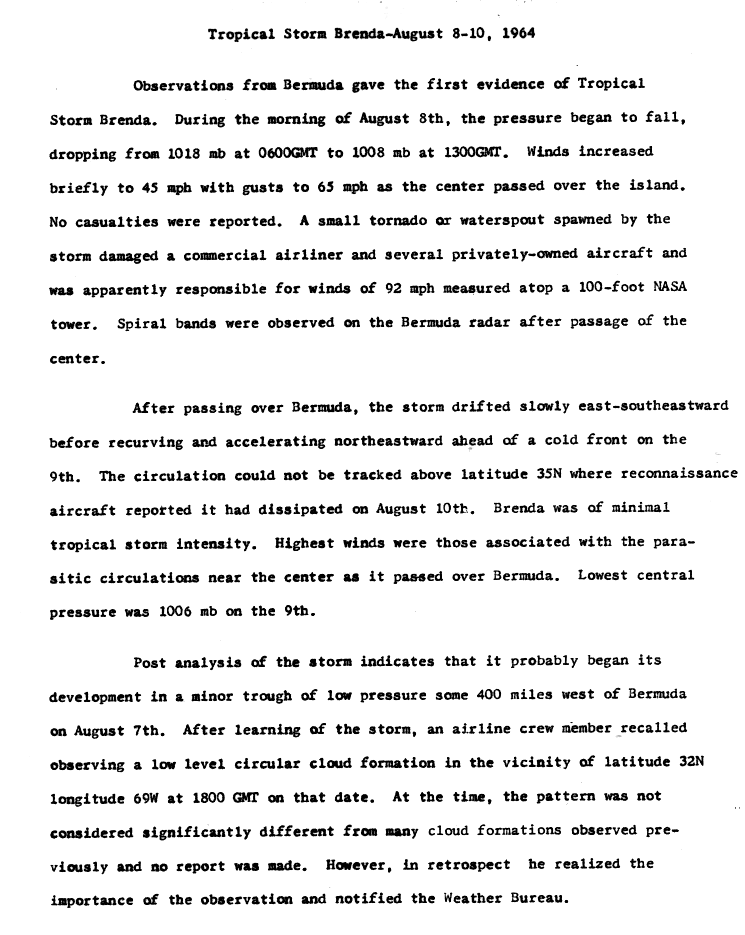
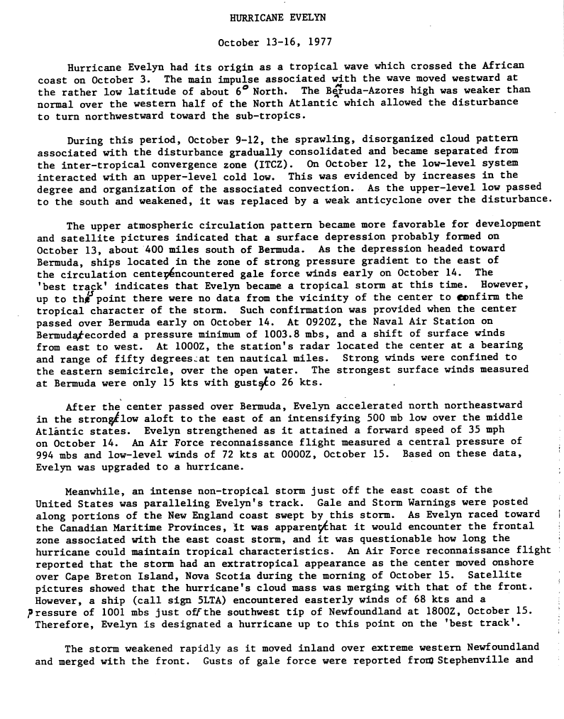
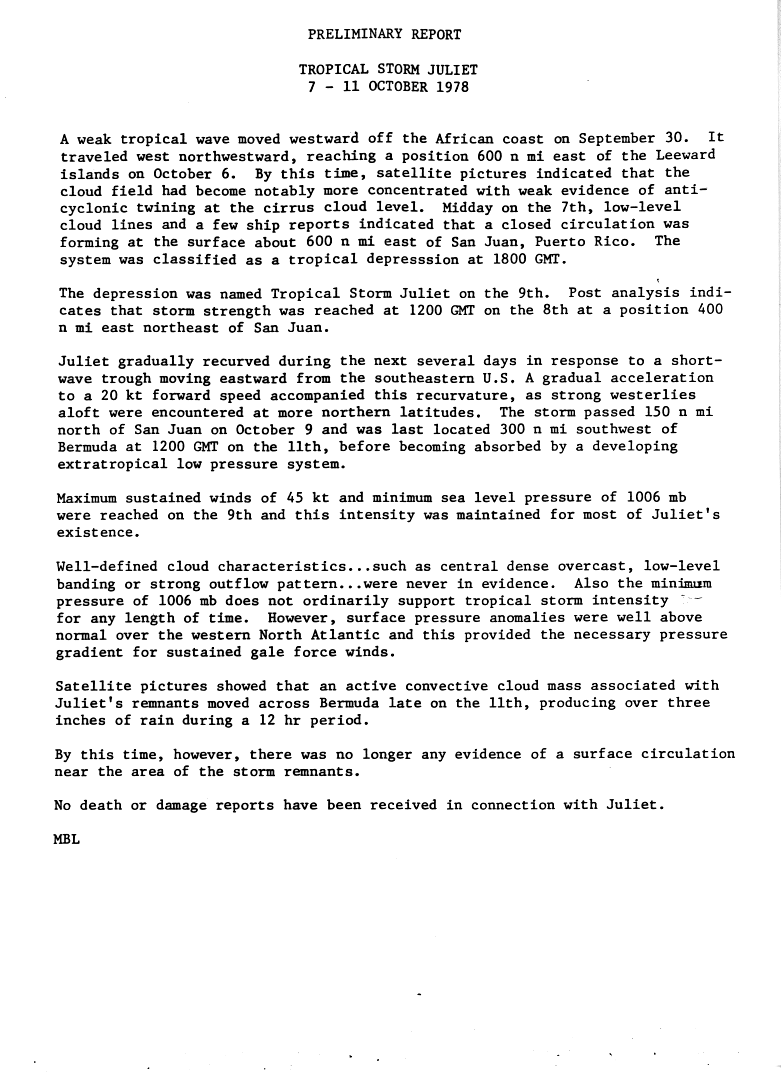
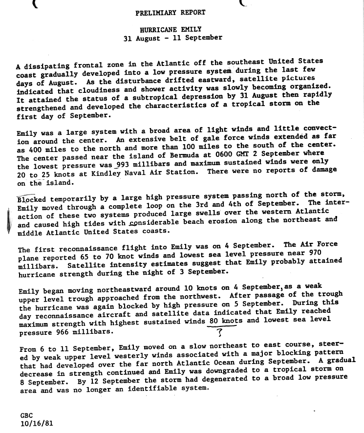
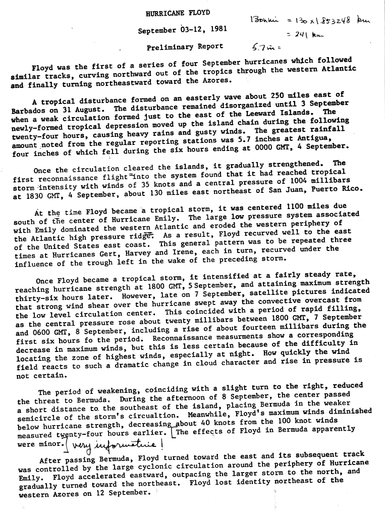
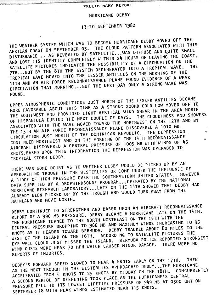
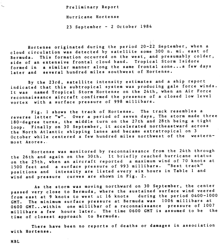
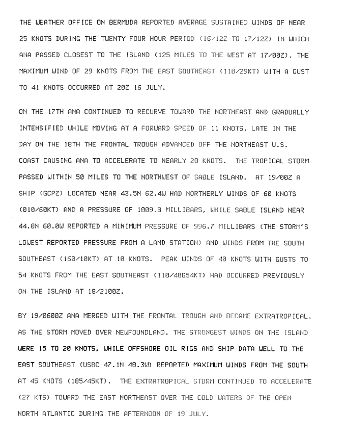
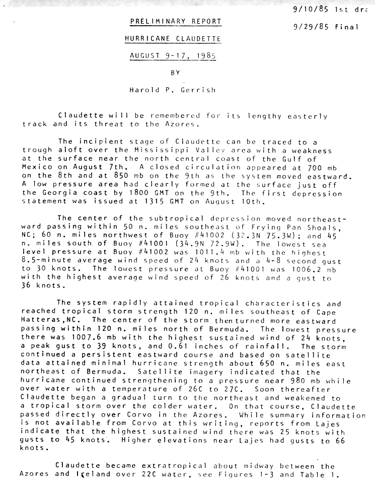
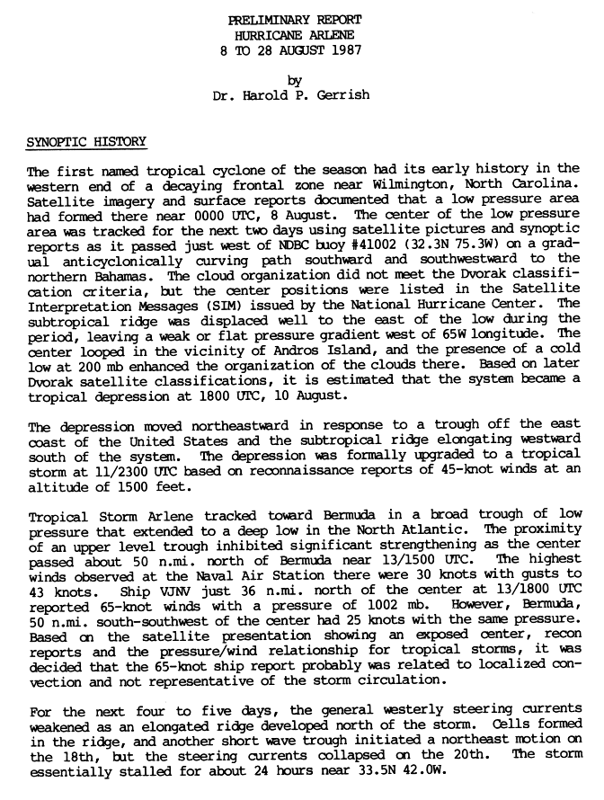
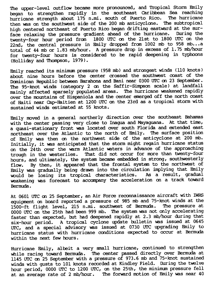
External links
- Bernews homepage
- The Royal Gazette homepage
- History of Bermuda from Bermuda Online
- Bermuda Weather Service
- United States National Hurricane Center