Tell Abyad District: Difference between revisions
Thepharoah17 (talk | contribs) |
Thepharoah17 (talk | contribs) Unsourced Tags: Reverted Mobile edit Mobile web edit |
||
| Line 63: | Line 63: | ||
}} |
}} |
||
'''Tell Abyad District''' ({{lang-ar|منطقة تل أبيض|Manṭiqat Tall Abyaḍ |
'''Tell Abyad District''' ({{lang-ar|منطقة تل أبيض|Manṭiqat Tall Abyaḍ}}) is a [[Districts of Syria|district]] of the [[Raqqa Governorate]] in northern [[Syria]]. The [[administrative centre]] is the city of [[Tell Abyad]]. |
||
{{multiple image |
{{multiple image |
||
|align=left |
|align=left |
||
Revision as of 08:50, 18 December 2020
Tell Abyad District
منطقة تل أبيض | |
|---|---|
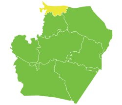
 Location of Tell Abyad District within Raqqa Governorate | |
| Coordinates (Tell Abyad): 36°41′51″N 38°57′24″E / 36.6975°N 38.9567°E | |
| Country | |
| Governorate | Raqqa |
| Seat | Tell Abyad |
| Subdistricts | 3 nawāḥī |
| Area | |
| • Total | 4,834.02 km2 (1,866.43 sq mi) |
| Population (2004)[1] | 129,714 |
| Geocode | SY1102 |
Tell Abyad District (Arabic: منطقة تل أبيض, romanized: Manṭiqat Tall Abyaḍ) is a district of the Raqqa Governorate in northern Syria. The administrative centre is the city of Tell Abyad.
Demographics
At the 2004 census, the district had a population of 129,714.[1] The majority of inhabitants are Sunni Arabs,[2] with considerable Sunni Kurdish[3][4] and Sunni Turkmen minorities. The western part of the district is mainly inhabited by Kurds, the Turkmens are mainly concentrated south west of Suluk and the town itself[5] and the rest of the district is almost all Arabs.
Subdistricts
The district of Tell Abyad is divided into three subdistricts or nawāḥī (population as of 2004[1]):
- Tell Abyad Subdistrict (ناحية تل أبيض): population 44,671.[6]
- Suluk Subdistrict (ناحية سلوك): population 44,131[7]
- Ayn Issa Subdistrict (ناحية عين عيسى): population 40,912.[8]
Archaeology
In the valley of the Balikh River, there exists an archaeological site called Tell Sabi Abyad.[9]
References
- ^ a b c "General Census of Population and Housing 2004" (PDF) (in Arabic). Syrian Central Bureau of Statistics. Archived from the original (PDF) on 8 December 2015. Retrieved 15 October 2015. Also available in English: "2004 Census Data". UN OCHA. Retrieved 15 October 2015.
- ^ "Arab Tribes Split Between Kurds And Jihadists". Carnegie Endowment for International Peace. 2015. Retrieved 26 June 2015.
- ^ "Kurds eye new corridor to Mediterranean". Al-Monitor.
- ^ "US Expresses Concerns About PYD Human Rights". BasNews. Retrieved 26 June 2015.
- ^ "Pre civil war ethno-religious map of Ar Raqqah goverornate - uMap". umap.openstreetmap.fr. Retrieved 2017-06-14.
- ^ "Tal Abyad nahiyah population". Cbssyr.org. Archived from the original on 2012-07-28. Retrieved 2012-07-05.
- ^ "Suluk nahiyah population". Cbssyr.org. Archived from the original on 2012-07-28. Retrieved 2012-07-05.
- ^ "Ayn Issa nahiyah population". Cbssyr.org. Archived from the original on 2012-07-28. Retrieved 2012-07-05.
- ^ Akkermans, P. M. M. G.; Archeology, Faculty of (1989). "Excavations at Tell Sabi Abyad – Prehistoric Investigations in the Balikh Valley, Northern Syria". International Series 468, (1989). Retrieved 2020-08-04.


