
Tongwynlais: Difference between revisions
Ponty Pirate (talk | contribs) distances were completely wrong. Cardiff, Pontypridd and Caerphilly ?? |
No edit summary |
||
| Line 1: | Line 1: | ||
[[Image:Cew whitchurch tongwynlais.jpg|thumb|right|150px|Tongwynlais and Whitchurch ward in Cardiff]] |
[[Image:Cew whitchurch tongwynlais.jpg|thumb|right|150px|Tongwynlais and Whitchurch ward in Cardiff]] |
||
'''Tongwynlais''' is a semi [[rural]] [[village]] in the Taff Valley. It is situated |
'''Tongwynlais''' is a semi [[rural]] [[village]] in the Taff Valley. It is situated 10 miles north of [[Cardiff city centre]] and 4 miles south of [[Pontypridd]] it is also 3 miles from [[Caerphilly]]. |
||
Tongwynlais used to be part of the county of [[Rhondda Cynon Taf]] along with the neighbouring villages of [[Gwaelod-y-garth]], Blaengwynlais, [[Creigiau]] and [[Pentyrch]], but they all became districts of Cardiff in 1996 as Cardiff expanded northwards beyond the [[M4 motorway]]. |
Tongwynlais used to be part of the county of [[Rhondda Cynon Taf]] along with the neighbouring villages of [[Gwaelod-y-garth]], Blaengwynlais, [[Creigiau]] and [[Pentyrch]], but they all became districts of Cardiff in 1996 as Cardiff expanded northwards beyond the [[M4 motorway]]. |
||
Revision as of 20:45, 14 June 2008
Tongwynlais is a semi rural village in the Taff Valley. It is situated 10 miles north of Cardiff city centre and 4 miles south of Pontypridd it is also 3 miles from Caerphilly.
Tongwynlais used to be part of the county of Rhondda Cynon Taf along with the neighbouring villages of Gwaelod-y-garth, Blaengwynlais, Creigiau and Pentyrch, but they all became districts of Cardiff in 1996 as Cardiff expanded northwards beyond the M4 motorway.
Overview
Tongwynlais lies on the slopes of Caerphilly mountain in the River Taff Valley. It is located within the Whitchurch & Tongwynlais electoral ward of Cardiff. Its population is just under 2000 [1] people, making it one of the smallest villages in Cardiff North.
Tongwynlais is conveniently located near Junction 32 of the M4 motorway, west to Bridgend and east to Newport, and the A470 trunk road, south to Cardiff and north to Pontypridd. The motorway separates Tongwynlais from the rest of Cardiff. Its most notable building is the Victorian folly or mock castle called Castell Coch (Welsh: Red Castle) which is open to the public. The area also has its own primary school.
The north of the village borders the county it used to belong to, Rhondda Cynon Taff and also Caerphilly. The nearest shopping centres are Whitchurch, Caerphilly, Pontypridd and central Cardiff.
Tongwynlais has a few shops, two public houses, a rugby club and a chip shop. Tongwynlais also has a 9 hole golf course.
Places of worship
There are three churches in the village.
Climate
The average mean temperatures in February are 2*C and in July 16*C. The coldest temperature recorded on a personal weather so far in 2008 is -8.9*C and the warmest 27.5*C.[citation needed]
Music
The band RocketGoldStar wrote a song about the village and recorded it for a BBC Radio 1 Maida Vale Session.[citation needed]
Images
-
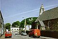 Tongwynlais Village Square
 -
A typical street of Tongwynlais in winter.
-
The countryside and mountain slopes withen the Village ward.
-
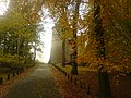 The Castle in Auturm.
 -
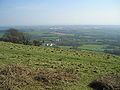 Eastern Cardiff from slopes of Caerphilly mountain.
 -
 A path to the north of the village on the mountain.
 -
 Tongwynlais Countryside.


References
- ^ "2001 Census for Tongwynlais". Retrieved 2008-06-10.
External links
- GENUKI page
- www.geograph.co.uk : photos of Tongwynlais and surrounding area
- Map sources for Tongwynlais
51°31′52″N 3°14′49″W / 51.53117°N 3.24696°W

This Cardiff location article is a stub. You can help Wikipedia by expanding it. |