
Fátima, Portugal: Difference between revisions
crowd size reference |
m Add main image caption |
||
| Line 15: | Line 15: | ||
|image_skyline = Santuário de Fátima modified.jpg |
|image_skyline = Santuário de Fátima modified.jpg |
||
|imagesize = 300px |
|imagesize = 300px |
||
|image_caption = |
|image_caption = [[Sanctuary_of_Our_Lady_of_Fatima|Our Lady of Fátima Basilica]] |
||
|image_flag = |
|image_flag = |
||
|flag_size = |
|flag_size = |
||
Revision as of 17:20, 15 March 2009
Fátima | |
|---|---|
 | |
 Coat of arms | |
| Country | Portugal |
| District | Santarém |
| Municipality | Ourém |
| Parishes | 1 |
| Area | |
| • Total | 71.29 km2 (27.53 sq mi) |
| Population (2001) | |
| • Total | 10,302 |
| • Density | 144/km2 (370/sq mi) |
| Time zone | UTC0 (GMT) |
Fátima ( IPA: [ˈfatimɐ]) is a city in Portugal famous for the religious visions that took place there in 1917. The town itself has a population of 7,756[1] and is located in the municipality of Ourém, in the Centro Region and sub region of Medio Tejo. It is in district of Santarém and is included in the urban agglomeration of Leiria, in central Portugal, 187 km (116 mi) south of Porto and 123 km (76 mi) north of Lisbon.
Toponomy
The name of the town (formerly a small village) comes from the Arabic name Fatima (Fāţimah, Arabic: فاطمة ), and there is an unconfirmed legend that says it derives from a local Moorish princess named Fatima who, following her capture by Christian forces during the Reconquista, was converted to Catholicism, and was baptised before marrying the Count of Ourém in 1158.
Marian apparitions
Fátima's claim to fame is the shrine called the Basilica, built to commemorate the events of 1917 when three peasant children claimed to have seen the "Virgin of the Rosary", Our Lady of Fátima. When the children asked for her name, she said "I am The Lady of The Rosary". The children experienced the purported Marian apparitions in a pasture called the Cova da Iria.
Economy
The economy of the town relies on religious tourism. Fátima now attracts hosts of believers from far and wide, particularly on the pilgrimage days, and the shrine has been developed on a correspondingly large scale. The town has a considerable number of shops and stalls selling all kinds of religious articles, and the streets of the town have plenty of hotels, hostels and restaurants.
Religious events
The large torch-light processions in honor of the Virgin Mary, which is organised in the evening, are particularly impressive. The pilgrims gather in the Cova, on a huge esplanade in which is built a little chapel where the Virgin is believed to have appeared to the children.
The Marian shrine in Fatima, Portugal attracts a large number of Catholics, and every year pilgrims fill the country road that leads to the shrine with crowds that approach one million on May 13th and October 13th, the significant dates of Fatima apparitions.[2]
On the far side of the esplanade rises the gigantic basilica, in neo-classical style, with a central tower 65 meters (213 ft) high, the construction of which was begun on 13 May 1928. It is flanked by colonnades linking it with the extensive conventual and hospital buildings. In the basilica are the tombs of the three seers, Jacinta and Francisco Marto, who died in 1919 and 1920 respectively in the Spanish flu pandemic, and were beatified in 2000, and Lúcia dos Santos who died in 2005. The Igreja da Santíssima Trindade, one of the largest churches in the world, was built on the other side of the esplanade during the 2000s.
Twin Towns
Fátima is twinned with:
 Częstochowa in Poland
 Loreto in Italy
Sports
Fátima's major sports club is the Centro Desportivo de Fátima which plays in the second highest football league of Portugal, the Liga Vitalis.
Gallery
-
 Basilica of the Rosary
 -
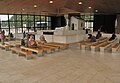
 Inside the Basilica
 -
 The Chapel of Apparitions
 -
 Church of the Most Holy Trinity, the 4th largest catholic temple in the World


See also
- Three Secrets of Fátima
- Our Lady of Fátima
- Shrines to the Virgin Mary
- Marian apparition
- Pope John Paul II
- The Miracle of the Sun
References
- ^ UMA POPULAÇÃO QUE SE URBANIZA, Uma avaliação recente - Cidades, 2004 Nuno Pires Soares, Instituto Geográfico Português (Geographic Institute of Portugal)
- ^ Trudy Ring, 1996, International Dictionary of Historic Places, ISBN 9781884964022 page 245