
Clingmans Dome: Difference between revisions
Wikiuser100 (talk | contribs) |
Added a link to the official site. |
||
| Line 92: | Line 92: | ||
==See also== |
==See also== |
||
*[[List of U.S. states by elevation]] |
*[[List of U.S. states by elevation]] |
||
==External links== |
|||
*Official site: [http://www.nps.gov/grsm/planyourvisit/clingmansdome.htm Clingmans Dome] |
|||
== References == |
== References == |
||
Revision as of 03:37, 29 July 2009
| Clingmans Dome |
|---|
Clingmans Dome (or Clingman's Dome) is a mountain in the Great Smoky Mountains of Tennessee and North Carolina, in the southeastern United States. At an elevation of 6,643 feet (2,025 m), it is the highest mountain in the Great Smokies, the highest point in the state of Tennessee, and the highest point along the 2,174-mile (3,499 km) Appalachian Trail. It is the third-highest mountain in the state of North Carolina and the third-highest in the entire Appalachian mountain range.[3]
Clingmans Dome is currently protected as part of the Great Smoky Mountains National Park. A paved road, closed in winter (December 1 through March 31),[4] connects it to U.S. Highway 441 (Newfound Gap Road) near Newfound Gap. A concrete observation tower was built on the site in 1959, offering a panoramic view of the mountains in each direction and helping to promote the site as a major tourist destination. The area is developed with picnic tables and running-water restrooms. The Environmental Protection Agency operates an air quality monitoring station on the summit, the second highest in eastern North America. The summit of Clingmans Dome is coated by a stand of Southern Appalachian spruce-fir forest, which occurs only at the highest elevations in the southeastern United States, and has more in common with forests at northern latitudes than with forest in adjacent valleys. Like most peaks in the Great Smoky Mountains, Clingmans Dome climbs prominently above the surrounding terrain, rising nearly 5,000 feet (1,500 m) from base to summit.
History

Reputedly known as "Kuwahi" (the mulberry place) by the Cherokee Indians, the mountain was originally dubbed "Smoky Dome" by the region's early Euro-American settlers. In 1859, the mountain was henceforth renamed by Arnold Guyot for compatriot Thomas Lanier Clingman (1812-1897), a American Civil War general who extensively explored the area in the 1850s and spent many years thereafter promoting it. Guyot named the mountain for Clingman because of an argument between Clingman and a professor at the University of North Carolina, Elisha Mitchell, over which mountain was actually the highest in the region. Mitchell contended that a peak by the name of Black Dome (now known as Mount Mitchell) was the highest, while Clingman asserted that Smoky Dome was instead the true highest peak. Guyot determined that Smoky Dome was 39 feet (12 m) shorter than Black Dome.
Geology
Clingmans Dome, like most of the Great Smokies, consists of a type of lightly metamorphosed sedimentary rock (especially sandstone) that is part of a formation known as the Ocoee Supergroup. These rocks were created from ancient ocean sediments nearly one billion years ago. Although a dense forest understory covers most of the mountain, this rock type is noticeable in rock outcroppings and in a large boulder pile at the Forney Ridge Parking Lot at the end of Clingmans Dome Road. The actual age of the mountains is somewhat speculative, but they are among the oldest in the world, created approximately 200-300 million years ago in the Alleghenian orogeny.
Clingmans Dome has two subpeaks: 6,560-foot (2,000 m) Mount Buckley to the west and 6,400-foot (2,000 m) Mount Love to the east. The headwaters of several substantial streams are located on the slopes of Clingmans Dome, namely Little River on the north slope, and Forney Creek and Noland Creek (both tributaries of the Tuckasegee River) on the south slope. The mountain is located entirely within the Tennessee River watershed.
Access

Clingmans Dome is the most accessible mountain top in the Great Smoky Mountains National Park. Closed from December 1 through March 31,[4] the 7-mile (11 km) Clingmans Dome Road begins just past Newfound Gap and leads up the mountain to the Forney Ridge Parking Area, 300 feet (91 m) below the summit. A 0.5-mile (0.80 km) paved trail leads from the parking lot to the 54-foot (16 m) observation tower at the top of the mountain.[5] The short, steep trail provides public restrooms, garbage cans, and numerous benches to the side of the path. The trail offers a glimpse of the often hostile environment of highland Appalachia, passing through the spruce-fir forest and its accompanying blowdowns and dead Fraser Firs. The observation tower allows spectators a 360 degree panorama of the surrounding mountains, on the infrequent occasion of a clear, sunny day. Cantilevered signs, hanging from the rails of the tower, point out the various peaks, ridges, cities, and other features visible in the distance. Depending on the haze, visibility ranges from 20 miles (32 km) on hazy days to 100 miles (160 km) on very clear days.
The Appalachian Trail crosses Clingmans Dome, passing immediately north of the observation tower. A 7.5-mile (12.1 km) leg of the trail connects the mountain with Newfound Gap, and provides the only non-overnight access to the mountain in winter months. The nearest A.T. backcountry shelters are the Double Spring Gap Shelter, which is 2.6 miles (4.2 km) to the west near the Goshen Prong junction, and the Mount Collins shelter, which is 4 miles (6.4 km) to the east near the A.T.'s Sugarland Mountain Trail junction. Clingmans Dome is the base for several additional hiking trails, including the Forney Ridge Trail (to Andrews Bald) and the Forney Creek Trail (to the Benton MacKaye Trail on the shores of Fontana Lake). The Mountains-to-Sea Trail, which connects the Smokies to the Outer Banks of North Carolina, intersects the Appalachian Trail 3.5 miles (5.6 km) east of Clingmans Dome.
1946 Aircraft Crash
In the early morning hours of June 12, 1946, a Boeing B-29 Superfortress crashed near the summit of Clingmans Dome, killing all twelve aboard.[6]
Photo gallery
-
 Mount Le Conte rising above Sevier Co., viewed from Clingmans Dome
 -
 The southwestern Smokies, viewed from the Forney Ridge Parking Area
 -
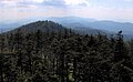 The view west from the summit of Clingmans Dome
 -
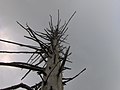 Dead Fraser fir along the tower trail
 -
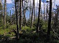 Spruce-fir forest at the summit of Clingmans Dome
 -
 The Forney Ridge Parking Area in dense cloud cover


See also
External links
- Official site: Clingmans Dome
References
- ^ a b c "Clingmans Dome". Geographic Names Information System. United States Geological Survey, United States Department of the Interior. Retrieved 2008-12-28.
- ^ "Clingmans Dome, Tennessee/North Carolina". Peakbagger.com. Retrieved 2008-12-21.
- ^ http://www.nps.gov/grsm/planyourvisit/clingmansdome.htm
- ^ a b "Clingmans Dome". Great Smoky Mountains National Park: National Park Service. Retrieved 2008-12-28.
- ^ "Clingmans Dome". SummitPost.org. Retrieved 2008-12-28.
- ^
Wadley, Jeff (2002). Mayday! mayday! : aircraft crashes in the Great Smoky Mountains National Park, 1920-2000. Knoxville: University of Tennessee Press. ISBN 1-57233-154-2.
{{cite book}}: Unknown parameter|coauthors=ignored (|author=suggested) (help)