
Battagram District: Difference between revisions
| Line 81: | Line 81: | ||
==Gallery== |
==Gallery== |
||
<gallery> |
|||
Image:A side view of Chappargram (Battagram) Before 2005 Quake.JPG|A side view of Chappargram (Battagram) Before 2005 Quake |
|||
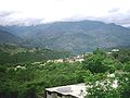
Image:batgram.jpg|Dedal, a village in the [[Battagram District]] |
|||
Image:Battagram City1.JPG|A Portion of [[Battagram]] City |
|||
</gallery> |
|||
==See also== |
==See also== |
||
Revision as of 00:28, 19 March 2010
Battagram District | |
|---|---|
 Location of Battagram District (highlighted in yellow) in the North-West Frontier Province. | |
| Country | |
| Province | North-West Frontier Province |
| Capital | Battagram |
| Government | |
| • District Nazim | Shams ur Rehman Shams |
| • District Naib Nazim | Niaz Muhmmad Khan Trand |
| Area | |
| • Total | 1,301 km2 (502 sq mi) |
| Elevation | 1,038 m (3,406 ft) |
| Population (1998) | |
| • Total | 307,278 |
| • Density | 236/km2 (610/sq mi) |
| Time zone | UTC+5 (PST) |
| Area code | 0997 |
| Number of Tehsils | 2 |
Battagram (Urdu: ضلع بٹگرام) is a district of Hazara in the North-West Frontier Province of Pakistan. It has a total land area of 1301 square kilometres and the estimated population of Battagram District in 2004-2005 was 361,000. Main language of the district is pashto.
Etymology
Before these nouveau inhabitants, Hindus were a majority in the area as the name of Battagram, (भटग्राम - Sanskrit which means Land or Village of the Warriors), suggest. Many other small villages in district Battagram are also still named after Sanskrit words or their old Hindu residents e.g. Chohan, Ajmera, Rashmera, Chapargram etc.
Administration
Battagram obtained the status of district in July 1993 when it was upgraded from a Tehsil and separated from Mansehra District. Before Battagram obtained the status of district, it was a Tehsil of the Mansehra District. It has geographical borders with Kohistan District, the Tribal Area of Kala Dhaka (Black Mountain of Hazara), Shangla District and Malakand Division. The district consists of two sub-divisions or Tehsils, containing 20 in total. Union Councils:[1]
| Tehsil | No. of Unions |
|---|---|
| Allai Tehsil | 8 |
| Batagram Tehsil | 12 |
The district is represented in the provincial assembly by two MPAs from its constituencies PF-59 (Battagram-1) and PF-60 (Battagram-2)[2].
Earthquake 2005
Battagram was one of the areas affected by the Pakistan Earthquake of October 8, 2005 when more than 4,500 people were killed and approximately 35,000 were injured. Many residents of the area were rendered homeless and without shelter. Since October 8th 2005, the NGOs and the Governmental organization ERRA have been engaged in re-construction work but as of 2009,the reconstruction work is not completed. In some cases residents have rebuilt houses themselves.
Scenery

This district is noted for its scenic mountain scenery, thick forests, fertile lands and enchanting streams. Most of the population is rural and depends upon agriculture for their day to day living. As a recent phenomenon, fishing has also become a mode of earning due to some modern scientific techniques. Another distinctive feature of this district is the notable presence of Shahrah-e-Resham (Karakoram Highway) or Silk route and hence which is helping the infant industrial base to thrive.
Gallery
-
 A side view of Chappargram (Battagram) Before 2005 Quake
 -
Dedal, a village in the Battagram District
-
 A Portion of Battagram City
_Before_2005_Quake.JPG)

See also
- List of Schools and Colleges in Battagram
- List of Hosptitals in Battagram
- Ajmera
- Alai
- Banna
- Banian
- Bateela
- Batkul
- Battagram
- Biari
- Chappargram
- Deshan
- Dedal
- Ethnic Groups in Battagram
- Gijbori
- Jambera
- Kotgalla
- Kuza banda
- Kala Dhaka
- Literacy in Battagram
- Main langauges
- Pagorha
- Paimal sharif
- Pashto
- Peshorha
- Rajdahri
- Rashang
- Shumlai
- Silk Route or Shahrah-e-Resham
- Tikri
- Thakot
- Trand
- Indus River
- Nandhiarh River
- Silk Route or Shahrah-e-Resham
References
Template:Administrative divisions of the North-West Frontier Province
Administrative divisions of Battagram District | ||
|---|---|---|
| Capital | ||
| Tehsils | ||
| Union councils | ||
| Village Councils | ||