
White Butte (North Dakota): Difference between revisions
mostly units |
No edit summary |
||
| Line 21: | Line 21: | ||
}} |
}} |
||
'''White Butte''' is the highest point in the [[U.S. state]] of [[North Dakota]]. At an elevation of 3,506 ft (1,069 m), it is a prominent [[butte]] in [[Slope County, North Dakota|Slope County]], in the [[Badlands]] of the southwestern part of the state |
'''White Butte''' is the highest point in the [[U.S. state]] of [[North Dakota]]. At an elevation of 3,506 ft (1,069 m), it is a prominent [[butte]] in [[Slope County, North Dakota|Slope County]], in the [[Badlands]] of the southwestern part of the state. |
||
The nearest town is [[Amidon, North Dakota|Amidon]], about seven miles to the northwest. The summit is located within the boundaries of the [[Little Missouri National Grassland]] and is about {{convert|35|mi|km}} south of [[Theodore Roosevelt National Park]]. It is on private property, owned by the Dennis family who live nearby. The family maintains a small mailbox-like receptacle for donations to help maintain the area, and requests a $10 contribution from visitors. |
The nearest town is [[Amidon, North Dakota|Amidon]], about seven miles to the northwest. The summit is located within the boundaries of the [[Little Missouri National Grassland]] and is about {{convert|35|mi|km}} south of [[Theodore Roosevelt National Park]]. It is on private property, owned by the Dennis family who live nearby {{Citation Needed}}. The family maintains a small mailbox-like receptacle for donations to help maintain the area, and requests a $10 contribution from visitors{{Citation Needed}}. |
||
The [http://www.topozone.com/map.asp?lat=47.50889&lon=-102.87667&datum=nad27&u=4&layer=DRG&size=l&s=48 Killdeer Mountains], {{convert|100|mi|km}} to the north, rise {{convert|900|ft|m}} from their foothills, but are {{convert|300|ft|m}} shorter than White Butte. |
The [http://www.topozone.com/map.asp?lat=47.50889&lon=-102.87667&datum=nad27&u=4&layer=DRG&size=l&s=48 Killdeer Mountains], {{convert|100|mi|km}} to the north, rise {{convert|900|ft|m}} from their foothills, but are {{convert|300|ft|m}} shorter than White Butte. |
||
Revision as of 05:17, 23 August 2011
| White Butte | |
|---|---|
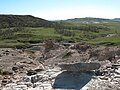
.JPG) A view of the shark fin rock from the top of the butte | |
| Highest point | |
| Elevation | 3,506 ft (1,069 m) |
| Prominence | 551 ft (168 m) |
| Listing | U.S. state high point |
| Geography | |
 White Butte | |
| Parent range | Chalky Buttes |
| Topo map | USGS Amidon |
| Climbing | |
| Easiest route | Hike (cattle trail) |
White Butte is the highest point in the U.S. state of North Dakota. At an elevation of 3,506 ft (1,069 m), it is a prominent butte in Slope County, in the Badlands of the southwestern part of the state.
The nearest town is Amidon, about seven miles to the northwest. The summit is located within the boundaries of the Little Missouri National Grassland and is about 35 miles (56 km) south of Theodore Roosevelt National Park. It is on private property, owned by the Dennis family who live nearby [citation needed]. The family maintains a small mailbox-like receptacle for donations to help maintain the area, and requests a $10 contribution from visitors[citation needed].
The Killdeer Mountains, 100 miles (160 km) to the north, rise 900 feet (270 m) from their foothills, but are 300 feet (91 m) shorter than White Butte.
-
 Looking to the west from the trail.
.JPG)
See also
References
External links
This North Dakota location article is a stub. You can help Wikipedia by expanding it. |