
Tarawa: Difference between revisions
m →Trivia: new info |
m →External links: added new link |
||
| Line 101: | Line 101: | ||
*[http://www.uscg.mil/history/uscghist/Mascots_2.asp "Tarawa" the USCG cat] |
*[http://www.uscg.mil/history/uscghist/Mascots_2.asp "Tarawa" the USCG cat] |
||
*[http://www.history.navy.mil/ac/exploration/wilkes/wilkes.html Exhibit: The Alfred Agate Collection: The United States Exploring Expedition, 1838-1842] from the Navy Art Gallery |
*[http://www.history.navy.mil/ac/exploration/wilkes/wilkes.html Exhibit: The Alfred Agate Collection: The United States Exploring Expedition, 1838-1842] from the Navy Art Gallery |
||
*[http://www.returntotarawa.com/Return to Tawara] |
|||
{{Kiribati}} |
{{Kiribati}} |
||
Revision as of 21:11, 14 April 2012


Tarawa is an atoll in the central Pacific Ocean, previously the capital of the former British colony of the Gilbert and Ellice Islands. It is the location of the capital of the Republic of Kiribati, South Tarawa. The island is best known by outsiders as the site of the Battle of Tarawa during World War II.
Geography
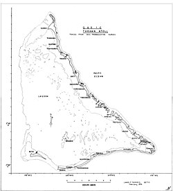
Tarawa consists of around 24 larger islets, of which at least eight are inhabited. The largest islet (South Tarawa) extends from Bonriki (southeast corner of the atoll) along the entire south side but Betio of the lagoon to Bairiki. A causeway, called the "Japanese causeway", now connects Bairiki to Betio. The largest town, Bikenibeu, and the only airport on Tarawa, Bonriki International Airport, are on South Tarawa. Tarawa is located at approximately latitude 1°22'47" N, longitude 173°09'06" E (Bonriki Airport).
Islets
- Abanuea (submerged since 1999 due to changing ocean currents)
- Abaokoro
- Abatao
- Bairiki
- Betio
- Bikeman Island (now submerged due to changing ocean currents)
- Biketawa
- Bonriki
- Buariki
Villages on Tarawa

Towns and villages
Demographics
The population as of 1990 was 28,802. The population is mostly Gilbertese (Micronesian). This probably exceeds the carrying capacity of the islands and is maintained at its current level without starvation principally due to foreign aid, largely from Australia, Japan and New Zealand.
Overcrowding
Between 1995 and 2000, a prominent wave of immigrants from the outer islands settled in South Tarawa, causing an urban growth rate of 5.2%. Although the immigration plateaued during the five following years, the overcrowding persisted in several areas of the atoll.[1] The overcrowding triggered the concern about unsustainable development in South Tarawa.[2] Anote Tong's administration undertook different measures in order to ease the problem in the country's main urban center, including the buildings of centers to spread out around the islands and relieve the atoll from the overcrowding issue.[3]
Administration
Tarawa atoll has three administrative subdivisions:
- Teinainano Urban Council (or TUC), from Bairiki to Bonriki, known in English as South Tarawa, the capital of the Republic of Kiribati;
- Betio Town Council (or BTC), on Betio Islet;
- North Tarawa or Tarawa Ieta (all the islets on the east side north of Bonriki).
The main administrative center for the Republic of Kiribati is located at Bairiki on South Tarawa. The Parliament meets on Ambo islet and some administration offices are on Betio Islet and in Bikenibeu and one is located on Kiritimati.
History

Thomas Gilbert, captain of the East India Company vessel Charlotte, was the first European to describe Tarawa, arriving on June 20, 1788.[4] Gilbert's 1788 sketches survive.
Sir Arthur Grimble was a cadet administrative officer based at Tarawa (1913–1919);.[5] and became Resident Commissioner of the Gilbert and Ellice Islands colony in 1926.[6]
During World War II, Tarawa was occupied by the Japanese, and beginning on November 20, 1943 it was the scene of the bloody Battle of Tarawa. On that day United States Marines landed on Tarawa and suffered heavy losses from Japanese soldiers occupying entrenched positions on the atoll. The Marines secured the island after 76 hours of intense fighting with around 6,000 dead in total from both sides.
Economy
Betio Islet includes the main port through which copra and pearl shell are exported. S.P.M.S, South Pacific Marine Service is a crewing agency in Tarawa. Currently there are more than 950 seamen working for S.P.M.S worldwide.
The currency of Kiribati is the Australian dollar.
Education
- Tarawa is the site of a teachers' training college and a marine training school.
Literature
- A Pattern of Islands by Sir Arthur Grimble, John Murray & Co, London, 1952; republished 2011 by Eland, London, ISBN 978-1906011-45-1
- Return to the Islands by Sir Arthur Grimble, John Murray & Co, London, 1957
Trivia
- The book The Sex Lives of Cannibals by J. Maarten Troost is a rather humorous account of the author's two years living on Tarawa.
- Tarawa is the site of the 1944 Pulitzer Prize winning photograph by Frank Filan, depicting a destroyed bunker.
- The book Return to Mars by Ben Bova uses Tarawa as the mission control for an expedition to Mars.
- The Far Reaches, a book of historical fiction by Homer Hickam, describes the Battle of Tarawa (ISBN 0-312-334753).
- A British drama film Pacific Destiny based on the book A Pattern Of Islands was made in 1956.
- Leon Cooper, a US Navy Landing Craft Operator who took part in the WWII battle, returned to the island in 2008 to investigate reports the beach he landed on was littered with garbage. His journey was chronicled in the documentary "Return to Tarawa: The Leon Cooper Story," narrated by Ed Harris.
Memorial
- USS Tarawa is the name of the first LHA-class amphibious assault ship.
Notes
- ^ "Kiribati health information profile". World Health Organization - Western Pacific Ocean. World Health Organization. Retrieved 9 June 2011.
- ^ "Kiribati profile on New Zealand's Ministry of Foreign Affairs and Trade official Site". New Zealand's Ministry of Foreign Affairs and Trade. Retrieved 9 June 2011.
- ^ Pareti, Samisoni. "Politics: Easing congestion and overcrowding". Island Business. Islands Business International. Retrieved 9 June 2011.
- ^
Samuel Eliot Morison (1944-05-22). "The Gilberts & Marshalls: A distinguished historian recalls the past of two recently captured pacific groups". Life magazine. Retrieved 2009-10-14.
Being now abreast of this island, the extremity ending in a beautiful clump of trees, I hauled up to look at the bay. It appeared to be safe and commodious, sheltered by a long reef running parallel with the island, with two large inlets into the bay. The reef is about 3/4 of a mile from the beach, and has several small islands which appear like flower pots.
- ^ Grimble, Sir Arthur (1952). "A Pattern of Islands". Early New Zealand Books (NZETC). Retrieved 16 Oct. 2011.
{{cite web}}: Check date values in:|accessdate=(help) - ^ Grimble, Sir Arthur. A Pattern of Islands. John Murray & Co, London, 1952; republished 2011 by Eland, London. ISBN 978-1906011-45-1.
{{cite book}}: Cite has empty unknown parameter:|chapterurl=(help)