
Robin Hood's Bay: Difference between revisions
→Fishing and lifeboats: minor tweaks |
|||
| Line 53: | Line 53: | ||
==Governance== |
==Governance== |
||
Robin Hood's Bay was part of the chapelry of Fylingdales in the Liberty of |
Robin Hood's Bay was part of the chapelry of Fylingdales in the Liberty of Whitby Stand which was a [[wapentake]] in the [[North Riding of Yorkshire]]. |
||
==Geography== |
==Geography== |
||
Revision as of 11:47, 24 April 2014
| Robin Hood's Bay | |
|---|---|
 Robin Hood's Bay's narrow streets | |
| OS grid reference | NZ950053 |
| Civil parish | |
| District | |
| Shire county | |
| Region | |
| Country | England |
| Sovereign state | United Kingdom |
| Post town | WHITBY |
| Postcode district | YO22 |
| Dialling code | 01947 |
| Police | North Yorkshire |
| Fire | North Yorkshire |
| Ambulance | Yorkshire |
| UK Parliament | |
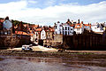
Robin Hood’s Bay is a small fishing village and a bay located within the North York Moors National Park, five miles south of Whitby and 15 miles north of Scarborough on the coast of North Yorkshire, England. Bay Town, its local name, is in the ancient chapelry of Fylingdales in the wapentake of Whitby Strand.
History
Toponymy
The origin of the name is uncertain, and it is doubtful if Robin Hood was ever in the vicinity. An English ballad and legend tell a story of Robin Hood encountering French pirates who came to pillage the fisherman's boats and the northeast coast. The pirates surrendered and Robin Hood returned the loot to the poor people in the village that is now called Robin Hood's Bay.[citation needed]
Early history
By about 1000 the neighbouring hamlet of Raw and village of Thorpe (Fylingthorpe) in Fylingdales had been settled by Norwegians and Danes. After the Norman Conquest in 1069 much land in the North of England, including Fylingdales, was laid waste. William the Conqueror gave Fylingdales to Tancred the Fleming who later sold it to the Abbot of Whitby.[1] The earliest settlements were about a mile inland at Raw but by about 1500 a settlement had grown up on the coast. "Robin Hoode Baye" was first mentioned by Leland in 1536 who described it as,[2]
"A fischer tounlet of 20 bootes with Dok or Bosom of a mile yn length."[3]
In the 16th century Robin Hood's Bay was a more important port than Whitby, it is described by a tiny picture of tall houses and an anchor on old North Sea charts published by Waghenaer in 1586 and now in Rotterdam's Maritime Museum.[4] After the Dissolution of the Monasteries in 1540, Whitby Abbey and its lands became the property of King Henry VIII with King Street and King’s Beck dating from this time.[5]
Smuggling
The town, which consists of a maze of tiny streets, has a tradition of smuggling, and there is reputed to be a network of subterranean passageways linking the houses. During the late 18th century smuggling was rife on the Yorkshire coast. Vessels from the continent brought contraband which was distributed by contacts on land and the operations were financed by syndicates who made profits without the risks taken by the seamen and the villagers. Tea, gin, rum, brandy and tobacco were among the contraband smuggled into Yorkshire from the Netherlands and France to avoid the duty.[6]
In 1773 two excise cutters, the Mermaid and the Eagle, were outgunned and chased out of the bay by three smuggling vessels, a schooner and two shallops.[6] A pitched battle between smugglers and excise men took place in the dock over 200 casks of brandy and geneva (gin) and 15 bags of tea in 1779.[7]
Fishing and lifeboats

Fishing and farming were the original occupations followed by generations of Bay folk. Fishing reached its peak in the mid 19th century, fishermen used the coble for line fishing in winter and a larger boat for herring fishing. Fish was loaded into panniers and men and women walked or rode over the moorland tracks to Pickering or York.[8] Many houses in the village were built between 1650 and 1750 and whole families were involved in the fishing industry. Many families owned or part owned cobles. Later some owned ocean going craft.[9]
A plaque in the town records that a brig named "Visitor" ran aground in Robin Hood's Bay on 18 January 1881 during a violent storm. In order to save the crew, the lifeboat from Whitby was pulled 6 miles overland by 18 horses, with the 7 feet deep snowdrifts present at the time cleared by 200 men. The road down to the sea through Robin Hood's Bay village was narrow and had awkward bends, and men had to go ahead demolishing garden walls and uprooting bushes to make a way for the lifeboat carriage. It was launched two hours after leaving Whitby, with the crew of the Visitor rescued on the second attempt.[10][11][12]
The main legitimate activity had always been fishing, but this started to decline in the late 19th century. These days most of its income comes from tourism.[citation needed]
Robin Hood's Bay is also famous for the large number of fossils which may be found on its beach.
In 1912 Professor Walter Garstang of Leeds University, in cooperation with Professor Albert Denny of the University of Sheffield, established the Robin Hood's Bay Marine Laboratory, which continued on the site for the next 70 years.
Governance
Robin Hood's Bay was part of the chapelry of Fylingdales in the Liberty of Whitby Stand which was a wapentake in the North Riding of Yorkshire.
Geography
.jpg)
Robin Hood's Bay is built in a fissure between two steep cliffs. The village houses were built mostly of sandstone with red-tiled roofs. The main street is New Road, which descends from the cliff top where the manor-house, the newer houses and the church of St Stephen stand. It passes through the village crossing the King's Beck and reaches the beach by a cobbled slipway known as Wayfoot.
The cliffs are Upper Lias shale capped by Dogger and False Bedded Sandstones and shales of the Lower Oolite.[2]
The Wine Haven-Profil near Robin Hood’s Bay is Global Stratotype Section and Point (GSSP) of Pliensbachian Epoch (183,0–189,6 mya), one of four chronographic substages of Early Jurassic Epoch.[13]
Transport
The town was once served by Robin Hood's Bay railway station[14] on the Scarborough and Whitby Railway line which opened in 1885 and closed in 1965. The track of the old railway is now a footpath and cycleway. The nearest railway station is in Whitby.
The town connects to the A171 allowing access to Whitby and Scarborough. The 93 and X93 Arriva bus services between Scarborough and Middlesbrough pass through Robin Hood's Bay.[15] Robin Hood's Bay is the eastern terminus of Wainwright's Coast to Coast Walk. Robin Hood's Bay is also on the coastal section of the Cleveland Way, a long distance footpath.
Religion
.jpg)
Robin Hood's Bay is in the parish of Fylingdales which contains two churches both dedicated to St Stephen. The Old St Stephen's Church, Fylingdales, on the hill side at Raw, above the village, replaced an ancient church which had Saxon origins and was demolished in about 1821 and was a dependent chapel of Whitby Abbey. A new church, also St Stephens, designed by George Edmund Street, was built in 1870 near the railway station.[2]
Culture
Robin Hood's Bay is the setting for the Bramblewick novels (Three Fevers, Phantom Lobster, Foreigners and Sally Lunn) by Leo Walmsley, who was educated in the schoolroom of the old Wesleyan Chapel, in the lower village. "Robin Hood's Bay" is a poem by children's poet Michael Rosen.
The Bayfair newspaper contains news and local information on the town. Wireless internet access is provided for visitors all around the town by the Bay Broadband Co-operative.
In 1948 Life Magazine ran a story of an unknown Poison Penman who had been writing spiteful anonymous letters to the inhabitants of Robin Hood Bay since 1928.[16]
The 2008 film Wild Child contains several scenes filmed at Robin Hood's bay.[17]
Gallery
-
 King Street in Robin Hood's Bay
 -
 Robin Hood's Bay - view from the sea
 -
 Robin Hood's Bay from the Cleveland Way.
 -
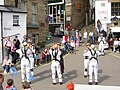 Morris Dancers in Robin Hood's Bay


References
Notes
- ^ Farnill 1966, p. 12
- ^ a b c Page William (editor) (1923), "Parishes:Fylingdales", A History of the County of York North Riding: Volume 2, Victoria County History, British History Online, pp. 534–537, retrieved 4 September 2010
{{citation}}:|author=has generic name (help) - ^ Farnill 1966, p. 13
- ^ Farnill 1966, p. 14
- ^ Farnill 1966, p. 16
- ^ a b Farnill 1966, p. 22
- ^ Farnill 1966, p. 34
- ^ Farnill 1966, p. 43
- ^ Farnill 1966, p. 44
- ^ Plaque, timetravel-britain.com, retrieved 6 January 2010
- ^ http://www.whitby-yorkshire.co.uk/lifeboat/lifeboats.htm More information
- ^ http://www.whitbysights.co.uk/whitby-history/lifeboathistory.html More information
- ^ GSSP for the Sinemurian-Pliensbachian Boundary, www.stratigraphy.org
- ^ RHB Station, Subterranea Britannica, retrieved 2 January 2010
- ^ Arriva Buses, arrivabus.co.uk, retrieved 2 January 2010
- ^ Life Magazine 31 May 1948 .pp. 45–46
- ^ "IMDB Wild Child filming locations"
Bibliography
- Farnill, Barrie (1966), Robin Hood's Bay The Story of a Yorkshire Community, Dalesman Publishing Co. Ltd.
- M.K. Howart: The Lower Lias of Robin Hood's Bay, Yorkshire, and the work of Leslie Bairstow. In: Bulletin of The Natural History Museum. Geology Series 58/2002, S. 81–152 Cambridge University Press, The Natural History Museum, 2002, doi:10.1017/S0968046202000037 (abstract)
External links
- Local information website
- News, pictures and holiday accommodation for Robin Hood's Bay
- Local Robin Hood's Bay Mini Guide
- Lost Brig The brig Elizabeth Jane, launched at Guysborough, Nova Scotia, in 1817, was abandoned off Robin Hood's Bay on 8 July 1854. Her crew were picked up by the Samuel of Grimsby and set down at Bridlington Quay on the morning of 9 July. The vessel washed ashore at Ravenscar and was built into a house at Robin Hood's Bay. Her timbers, including nameboard and port of registration board, were only discovered when a cottage ceiling was removed in 2003.