
Nine-dash line: Difference between revisions
HMSLavender (talk | contribs) m Reverted 1 edit by 121.54.54.164 identified as test/vandalism using STiki |
→Ongoing disputes: typo - dupe phrase |
||
| Line 23: | Line 23: | ||
== Ongoing disputes == |
== Ongoing disputes == |
||
According to Philippine President [[Benigno Aquino III]], "China’s 9-dash line territorial claim over the entire South China Sea is against international laws, particularly the [[United Nations Convention on the Law of the Sea|United Nations Convention of the Laws of the Sea]] (UNCLOS)".<ref name=aquino>{{cite web| title = Aquino mulls UN protest on Spratlys|first=Regina |last=Bengco|url=http://maritimesecurity.asia/south-china-sea-2/aquino-mulls-un-protest-on-spratlys/| publisher = Maritime Security Asia| date= 2 June 2011}}</ref> Vietnam also rejected the 9-dotted line claim, citing that it is baseless and against the UNCLOS.<ref name =oxlip>{{cite web|title= |
According to Philippine President [[Benigno Aquino III]], "China’s 9-dash line territorial claim over the entire South China Sea is against international laws, particularly the [[United Nations Convention on the Law of the Sea|United Nations Convention of the Laws of the Sea]] (UNCLOS)".<ref name=aquino>{{cite web| title = Aquino mulls UN protest on Spratlys|first=Regina |last=Bengco|url=http://maritimesecurity.asia/south-china-sea-2/aquino-mulls-un-protest-on-spratlys/| publisher = Maritime Security Asia| date= 2 June 2011}}</ref> Vietnam also rejected the 9-dotted line claim, citing that it is baseless and against the UNCLOS.<ref name =oxlip>{{cite web|title="Is the Ox's tongue line legal?"|author=Hoang Viet|url=http://www.bbc.co.uk/vietnamese/forum/2009/05/090515_china_sea_dispute.shtml | publisher=BBC|date=19 May 2009}}</ref> In 2010, at a regional conference in Hanoi, Secretary of State Hillary Clinton announced that "The United States has a national interest in freedom of navigation, open access to Asia's maritime commons, and respect for international law in the South China Sea".<ref name=uscomments>{{cite web|title=Beijing hits out at US comments on South China Sea|author=Associate Press (AFP)|url= http://www.terradaily.com/reports/Beijing_hits_out_at_US_comments_on_South_China_Sea_999.html |date=25 July 2010}}</ref> The United States has also called for unfettered access to the area that China claims as its own, and accused Beijing of adopting an increasingly aggressive stance on the high seas.<ref name= uscomments /> |
||
As early as 1958, the Chinese government released a document pertaining to its territorial limits,<ref>{{Cite web|title = http://www.fmprc.gov.cn/mfa_eng/wjb_663304/zzjg_663340/yzs_663350/xwlb_663352/W020140608617876545470.jpg|url = http://www.fmprc.gov.cn/mfa_eng/wjb_663304/zzjg_663340/yzs_663350/xwlb_663352/W020140608617876545470.jpg|website = www.fmprc.gov.cn|accessdate = 2015-07-08}}</ref> stating that China's territorial waters cover twelve nautical miles, and announcing that this provision applies to "all the territory of People's Republic of China, including the Chinese mainland and offshore islands, Taiwan and its surrounding islands, the Penghu Islands, the Dongsha Islands, Xisha Islands, Zhongsha Islands, the Nansha Islands and other islands belonging to China.<ref>{{cite web|title=The Operation of the HYSY 981 Drilling Rig: Vietnam's Provocation and China's Position|url=http://vn.china-embassy.org/chn/zgyw/t1163582.htm|date=2014-07-16}}</ref><ref>{{cite web|title=1958 'The People's Republic of China government's statement on the Territorial Sea' study(Chinese version)|url=http://news.xinhuanet.com/ziliao/2003-01/24/content_705061.htm|date=2003-01-24}}</ref> |
As early as 1958, the Chinese government released a document pertaining to its territorial limits,<ref>{{Cite web|title = http://www.fmprc.gov.cn/mfa_eng/wjb_663304/zzjg_663340/yzs_663350/xwlb_663352/W020140608617876545470.jpg|url = http://www.fmprc.gov.cn/mfa_eng/wjb_663304/zzjg_663340/yzs_663350/xwlb_663352/W020140608617876545470.jpg|website = www.fmprc.gov.cn|accessdate = 2015-07-08}}</ref> stating that China's territorial waters cover twelve nautical miles, and announcing that this provision applies to "all the territory of People's Republic of China, including the Chinese mainland and offshore islands, Taiwan and its surrounding islands, the Penghu Islands, the Dongsha Islands, Xisha Islands, Zhongsha Islands, the Nansha Islands and other islands belonging to China.<ref>{{cite web|title=The Operation of the HYSY 981 Drilling Rig: Vietnam's Provocation and China's Position|url=http://vn.china-embassy.org/chn/zgyw/t1163582.htm|date=2014-07-16}}</ref><ref>{{cite web|title=1958 'The People's Republic of China government's statement on the Territorial Sea' study(Chinese version)|url=http://news.xinhuanet.com/ziliao/2003-01/24/content_705061.htm|date=2003-01-24}}</ref> |
||
Revision as of 13:19, 26 August 2015

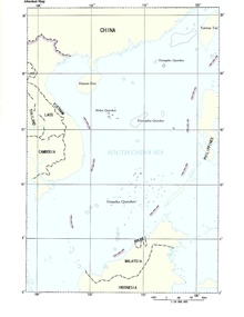
The nine-dotted line, nine-dashed line, U-shaped line, nine-dash map and similar names, including (Chinese: 南海九段线; pinyin: nánhǎi jiǔduàn xiàn; lit. 'Nine-segment line of the South China Sea'; Vietnamese: Đường lưỡi bò; "cow's tongue line"), (and at various times also referred to by names such as "The 10-dash line" and "The 11-dash line",[1][2] refer to the demarcation line used initially by the government of the Republic of China (ROC / Taiwan), and subsequently also by the government of the People's Republic of China (PRC), for their claims of the major part of the South China Sea (SCS).[3] The contested area in the SCS includes the Paracel Islands,[4] the Spratly Islands,[5][6] and various other areas including the Pratas Islands, the Macclesfield Bank and the Scarborough Shoal. The claim encompasses the area of Chinese land reclamation known as the "great wall of sand".[7][8][9][10]
An early map showing a U-shaped eleven-dotted line was published in the then Republic of China on 1 December 1947.[11] Two of the dots in the Gulf of Tonkin were later removed at the behest of Chinese Premier Zhou Enlai, reducing the total to nine.[12] Subsequent editions added dashes to the other end of the line, extending it into the East China Sea.[citation needed]
Despite having made the vague claim public in 1947, China is still (as of 2015[update]) to file a formal and specifically defined claim to the area within the dashes.[13] People's Republic of China re-leashed the tenth-dotted line on the east of Taiwan island in 2013 and 2014 as a part of the official sovereignty claim on the Territorial disputes in the South China Sea.[14][15][16]
History

Following the defeat of Japan at the end of World War II, the Republic of China re-claimed the entirety of the Paracels, Pratas and Spratly Islands after accepting the Japanese surrender of the islands based on the Cairo and Potsdam Declarations. In November 1946, the Republic of China sent naval ships to take control of these islands after the surrender of Japan.[17]
The nine-dotted line was originally an eleven-dotted-line first shown on a map published by the government of the Republic of China (1911–date, in Taiwan since 1949) in December 1947 to justify its claims in the South China Sea.[12] After the Communist Party of China took over mainland China and formed the People's Republic of China in 1949, the line was adopted and revised to nine as endorsed by Zhou Enlai.[12] After evacuating to Taiwan, the Republic of China has continued its claims, and the nine-dotted line remains as the rationale for Taiwan's claims to the Spratly and Paracel Islands.
The nine-dotted line has been used by China to show the maximum extent of its claim without indicating how the dots would be joined if it was continuous and how that would affect the extent of the area claimed by China.[12] The Philippines, Vietnam, Malaysia, Brunei and Indonesia have all officially protested over the use of such a line.[19] Immediately after China submitted a map to the UN including the 9-dotted lines territorial claim in the South China Sea on May 7, 2009, the Philippines lodged a diplomatic protest against China for claiming the whole of South China Sea illegally. Vietnam and Malaysia filed their joint protest a day after China submitted its 9-dash line map to the UN. Indonesia also registered its protest, even though it did not have a claim on the South China Sea.[6]
It is reported that in 2013 the PRC extended their claims with a new ten-dash map, but in fact the "new" dash is to the east of Taiwan, not in the South China Sea.[20]
Ongoing disputes
According to Philippine President Benigno Aquino III, "China’s 9-dash line territorial claim over the entire South China Sea is against international laws, particularly the United Nations Convention of the Laws of the Sea (UNCLOS)".[21] Vietnam also rejected the 9-dotted line claim, citing that it is baseless and against the UNCLOS.[22] In 2010, at a regional conference in Hanoi, Secretary of State Hillary Clinton announced that "The United States has a national interest in freedom of navigation, open access to Asia's maritime commons, and respect for international law in the South China Sea".[23] The United States has also called for unfettered access to the area that China claims as its own, and accused Beijing of adopting an increasingly aggressive stance on the high seas.[23]
As early as 1958, the Chinese government released a document pertaining to its territorial limits,[24] stating that China's territorial waters cover twelve nautical miles, and announcing that this provision applies to "all the territory of People's Republic of China, including the Chinese mainland and offshore islands, Taiwan and its surrounding islands, the Penghu Islands, the Dongsha Islands, Xisha Islands, Zhongsha Islands, the Nansha Islands and other islands belonging to China.[25][26]
Some parties have questioned the jurisdiction of the United Nations Convention of the Laws of the Sea on the dispute, arguing that the convention does not support claims based on sovereignty or title, and instead raises the right to continue using the waters for traditional purpose.[27][28]
While China has never used the 9-dotted line as an inviolable border to its sovereignty,[citation needed] this strategy together with the fact that China's authority has never officially explained the meaning of the 9-dotted line have led many researchers to try to derive the exact meanings of the 9-dotted line map in the Chinese strategy in the South China Sea. Some scholars believe that this line cannot be considered as a maritime boundary line because it violates maritime laws,[citation needed] , which states that a national boundary line must be a stable and defined one. The 9-dotted line is not stable because it has been reduced from 11 to 9 dashes in the Gulf of Tonkin as endorsed by Zhou Enlai without any reasons given. It is also not a defined line because it does not have any specific geographic coordinates and does not tell how it can be connected if it was a continuous line.[29] In October 2008, the website WikiLeaks published a cable from the U.S. Embassy in Beijing reporting that Yin Wenqiang, a senior Chinese government maritime law expert, had "admitted" he was unaware of the historical basis for the nine dashes.[30]
According to the Kyodo News, in March 2010 PRC officials told U.S. officials that they consider the South China Sea a "core interest" on par with Taiwan, Tibet and Xinjiang,[31] but subsequently backed away from that assertion[32][33][34] In July 2010 the Communist Party-controlled Global Times stated that "China will never waive its right to protect its core interest with military means"[35] and a Ministry of Defense spokesman said that "China has indisputable sovereignty of the South Sea and China has sufficient historical and legal backing" to underpin its claims.[36]
At the Conference on Maritime Study organized by the U.S.-based Center for Strategic and International Studies (CSIS) in June 2011, Su Hao of the China Foreign Affairs University in Beijing delivered a speech on China’s sovereignty and policy in the South China Sea, using history as the main argument. However, Termsak Chalermpalanupap, Assistant Director for Program Coordination and External Relations of the ASEAN Secretariat, said: “I don’t think that the 1982 United Nations Convention on the Law of the Sea (UNCLOS) recognizes history as the basis to make sovereignty claims”. Peter Dutton of the U.S. Naval War College agreed, saying, “The jurisdiction over waters does not have connection to history. It must observe the UNCLOS.” Dutton stressed that using history to explain sovereignty erodes the rules of the UNCLOS.[37] It is understood that China ratified the UNCLOS in 1996.[38]
Maritime researcher Carlyle Thayer, Emeritus Professor of Politics of the University of New South Wales, said that Chinese scholars using historical heritage to explain its claim of sovereignty shows the lack of legal foundation under the international law for the claim.[39] Caitlyn Antrim, Executive Director, Rule of Law Committee for the Oceans of the USA, commented that "The U-shaped line has no ground under the international law because [the] historical basis is very weak". She added "I don’t understand what China claims for in that U-shaped line. If they claim sovereignty over islands inside that line, the question is whether they are able to prove their sovereignty over these islands. If China claimed sovereignty over these islands 500 years ago and then they did not perform their sovereignty, their claim of sovereignty becomes very weak. For uninhabited islands, they can only claim territorial seas, not exclusive economic zones (EEZ) from the islands”.[37]
See also
References
- ^ Strategic Regions in 21st Century Power Politics. Cambridge Scholars Publishing. 26 November 2014. pp. 66–68. ISBN 9781443871341.
{{cite book}}: Unknown parameter|editors=ignored (|editor=suggested) (help) - ^ Michaela del Callar (July 26, 2013). "China's new '10-dash line map' eats into Philippine territory". GMA News.
- ^ Later revisions add claims to parts of the East China Sea.[citation needed]
- ^ The Paracel Islands are occupied by the PRC, but are also claimed by Vietnam and the ROC.
- ^ The Spratly Islands are disputed by the Philippines, PRC, ROC, Brunei, Malaysia, and Vietnam, who each claim either part or all the islands, which are believed (hoped) to sit on vast mineral resources, including oil and gas.
- ^ a b Jamandre, Tessa (14 April 2011). "PH protests China's '9-dash line' Spratlys claim". Malaya. Retrieved 2 June 2011.
- ^ "China building 'great wall of sand' in South China Sea - BBC News". BBC. 1 April 2015. Retrieved 2015-05-22.
- ^ "US Navy: Beijing creating a 'great wall of sand' in South China Sea". The Guardian. 31 March 2015. Retrieved 2015-05-22.
- ^ "China building a 'great wall of sand' in South China Sea– US Navy". RT. 31 March 2015. Retrieved 2015-05-22.
- ^ Marcus, Jonathan (29 May 2015). "US-China tensions rise over Beijing's 'Great Wall of Sand'". BBC. Retrieved 29 May 2015.
- ^ Wu 2013.
- ^ a b c d Brown, Peter J. (8 Dec 2009). "Calculated ambiguity in the South China Sea". Asia Times Online. Retrieved February 5, 2014.
- ^ Cheney-Peters, Scott (14 December 2014). "CHINA'S NINE-DASHED LINE FACES RENEWED ASSAULT". Retrieved 15 December 2014.
- ^ http://www.state.gov/documents/organization/234936.pdf
- ^ https://www.rusi.org/publications/newsbrief/ref:A5225D72CD72F8/#.VbLoO_mSzKA
- ^ http://www.thanhniennews.com/commentaries/new-tendashed-line-map-revealed-chinas-ambition-28816.html
- ^ Chen, King C. (1979). China's War with Vietnam, 1979: Issues, Decisions, and Implications. Hoover Press. p. 43. ISBN 0817985719.
- ^ "CML/17/2009 - Submission by the PRC to the UN Commission on the Limits of the Continental shelf" (PDF). United Nations. May 7, 2009. Archived from the original (PDF) on May 29, 2009. Retrieved Feb 20, 2015.
{{cite web}}: Unknown parameter|deadurl=ignored (|url-status=suggested) (help) - ^ Esplanada, Jerry E. (15 April 2011). "PH runs to UN to protest China's '9-dash line' Spratlys claim".
- ^ "China’s New Map: Just Another Dash?"
- ^ Bengco, Regina (2 June 2011). "Aquino mulls UN protest on Spratlys". Maritime Security Asia.
- ^ Hoang Viet (19 May 2009). ""Is the Ox's tongue line legal?"". BBC.
- ^ a b Associate Press (AFP) (25 July 2010). "Beijing hits out at US comments on South China Sea".
- ^ "http://www.fmprc.gov.cn/mfa_eng/wjb_663304/zzjg_663340/yzs_663350/xwlb_663352/W020140608617876545470.jpg". www.fmprc.gov.cn. Retrieved 2015-07-08.
{{cite web}}: External link in|title= - ^ "The Operation of the HYSY 981 Drilling Rig: Vietnam's Provocation and China's Position". 2014-07-16.
- ^ "1958 'The People's Republic of China government's statement on the Territorial Sea' study(Chinese version)". 2003-01-24.
- ^ Sourabh Gupta, Samuels International (11 Jan 2015). "Why US analysis of China's nine-dash line is flawed".
- ^ Sourabh Gupta (2014-12-15). "Testing China's - and the State Department's -nine-dash line claims" (PDF).
- ^ Foreign Press Center of Vietnam (25 July 2010). "The "9-dashed line" – an irrational claim".
- ^ "Analysis: China's nine-dashed line in [the] South China Sea". Reuters. May 25, 2012. Retrieved February 3, 2014.
- ^ Clinton Signals US Role in China Territorial Disputes After Asean Talks, Bloomberg, 2010-07-23
- ^ Wong, Edward (30 March 2011). "China Hedges Over Whether South China Sea Is a 'Core Interest' Worth War". The New York Times.
- ^ "Armed Clash in the South China Sea - Council on Foreign Relations". Cfr.org. Retrieved 2014-04-15.
- ^ "U.S. sees crisis fears easing over South China Sea". Mobile.reuters.com. Retrieved 2014-04-15.
- ^ American shadow over South China Sea, Global Times, 2010-07-26
- ^ China Says Its South Sea Claims Are ‘Indisputable’, Bloomberg, 2010-07-29
- ^ a b "International scholars discuss maritime security in the East Sea". m.english.vietnamnet.vn. 22 June 2011. Archived from the original on 2014-10-13.
{{cite web}}: Unknown parameter|deadurl=ignored (|url-status=suggested) (help) - ^ "Declarations or Statements upon UNCLOS Ratification". Division for Ocean Affairs and the Law of the Sea, United Nations Office of Legal Affairs. Retrieved February 22, 2013.
- ^ Thayer, Carlyle A. (July 14, 2011). "South China Sea disputes: ASEAN and China". Retrieved February 22, 2013.
Bibliography
- Wu, Shicun (2013). Solving Disputes for Regional Cooperation and Development in the South China Sea: A Chinese Perspective. Chandos Asian Studies Series. Elsevier Reed. ISBN 1780633556.
{{cite book}}: Invalid|ref=harv(help)