Theodore, Saskatchewan: Difference between revisions
Appearance
Content deleted Content added
copy edit, hide broken link |
Cyberbot II (talk | contribs) Rescuing 1 sources. #IABot |
||
| Line 77: | Line 77: | ||
| year = |
| year = |
||
| url =http://www.collectionscanada.ca/archivianet/post-offices/001001-100.01-e.php |
| url =http://www.collectionscanada.ca/archivianet/post-offices/001001-100.01-e.php |
||
| accessdate = }}</ref><ref>{{Citation|last=Government of Saskatchewan |first=MRD Home |author-link= |last2= |first2= |author2-link= |title=Municipal Directory System |date= |year= |url=http://www.municipal.gov.sk.ca/index.html |accessdate= |deadurl=yes |archiveurl=https://web.archive.org/20081121083646/http://www.municipal.gov.sk.ca/index.html |archivedate=November 21, 2008 }}</ref><ref>{{Citation |
|||
| accessdate = }}</ref><ref>{{Citation |
|||
| last =Government of Saskatchewan |
|||
| first =MRD Home |
|||
| author-link = |
|||
| last2 = |
|||
| first2 = |
|||
| author2-link = |
|||
| title = Municipal Directory System |
|||
| date = |
|||
| year = |
|||
| url =http://www.municipal.gov.sk.ca/index.html |
|||
| accessdate = |
|||
}} {{dead link|date=June 2010}}</ref><ref>{{Citation |
|||
| last =Canadian Textiles Institute. |
| last =Canadian Textiles Institute. |
||
| first = |
| first = |
||
Revision as of 19:53, 23 February 2016
Theodore | |
|---|---|
Village | |
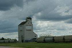
 Grain elevator in Theodore | |
| Country | Canada |
| Province | Saskatchewan |
| Rural Municipalities (R.M.) | Insinger No. 275, Saskatchewan |
| Post office Founded | 1893-12-01 |
| Area | |
| • Total | 1.73 km2 (0.67 sq mi) |
| Population (2006) | |
| • Total | 339 |
| • Density | 1.73/km2 (4.5/sq mi) |
| • Summer (DST) | CST |
| [1][2][3][4] | |
Theodore is a village in the rural municipality of Insinger No. 275, Saskatchewan, in the Canadian province of Saskatchewan. Theodore is located on Saskatchewan Highway 16, the Yellowhead, in southeastern Saskatchewan.[5] Theodore post office first opened in 1893 at the legal land description of Sec.1, Twp.28, R.7, W2 .[6] Theodore is located between Yorkton and Foam Lake.
In 1974, with the end of passenger rail service, the Theodore railway station was adopted for use as a senior citizens' centre; it serves as the home for the Theodore Historical Museum.[7]
Demographics
Canada census – Theodore, Saskatchewan community profile
| Population |
|---|
| Land area |
| Population density |
| Median age |
| Private dwellings |
| Median household income |
- N/A = Data Not Available
Area statistics
- Lat (DMS) 51° 25' 25" N
- Long (DMS) 102° 55' 15" W
- Dominion Land Survey Sec.15, Twp.28, R.7, W2.[10]
- Time zone (cst) UTC-6
Location
See also
Wikimedia Commons has media related to Theodore, Saskatchewan.
Notes and references
- ^ National Archives, Archivia Net, Post Offices and Postmasters
- ^ Government of Saskatchewan, MRD Home, Municipal Directory System, archived from the original on November 21, 2008
{{citation}}: Unknown parameter|deadurl=ignored (|url-status=suggested) (help) - ^ Canadian Textiles Institute. (2005), CTI Determine your provincial constituency
- ^ Commissioner of Canada Elections, Chief Electoral Officer of Canada (2005), Elections Canada On-line
- ^ a b Adamson, J, Rand McNally 1924 Saskatchewan Map, retrieved 2008-03-26
- ^ National Archives, Archivia Net, Post Offices and Postmasters, retrieved 2008-03-26
- ^ "Canadian Pacific Railway Station". Canada's Historic Places - a Federal Provincial and Territorial Collaboration. Retrieved 2011-03-20.
- ^ "2006 Community Profiles". 2006 Canadian Census. Statistics Canada. August 20, 2019.
- ^ "2001 Community Profiles". 2001 Canadian Census. Statistics Canada. July 18, 2021.
- ^ "Geonames", Natural Resources Canada, Government of Canada, retrieved 2008-03-26
