Bener Meriah Regency: Difference between revisions
Appearance
Content deleted Content added
No edit summary |
Rescuing 1 sources and tagging 0 as dead. #IABot (v1.2.6) |
||
| Line 110: | Line 110: | ||
== External links == |
== External links == |
||
* [http://www.benermeriahkab.go.id/ Bener Meriah Regency] {{id}} |
* [http://www.benermeriahkab.go.id/ Bener Meriah Regency] {{id}} |
||
* [http://www.ri.go.id/produk_uu/produk2003/uu2003/uu41'03.htm UU RI No.41 Tahun 2003] {{id}} |
* [https://web.archive.org/web/20060401064726/http://www.ri.go.id:80/produk_uu/produk2003/uu2003/uu41'03.htm UU RI No.41 Tahun 2003] {{id}} |
||
{{Aceh}} |
{{Aceh}} |
||
Revision as of 21:28, 30 October 2016
Bener Meriah Regency
بنر مرياه | |
|---|---|
 | |
| Country | Indonesia |
| Province | Aceh |
| Regency | 2003 |
| Capital | Simpang Tiga Redelong |
| Area | |
| • Total | 1,457.34 km2 (562.68 sq mi) |
| Population (2010) | |
| • Total | 121,870 |
| • Density | 84/km2 (220/sq mi) |
| Time zone | UTC+7 (WIB) |
| Area code | +62 643 |
| Website | http://www.benermeriahkab.go.id/ |
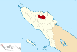
Bener Meriah Regency (Indonesian: Kabupaten Bener Meriah) is a regency in Aceh Special District, Indonesia. The regency covers an area of 1,457.34 square kilometres and according to the 2010 census had a population of 121,870 people. Its capital is Simpang Tiga Redelong. Until 2003 the territory of this regency was part of Central Aceh Regency.[clarification needed]
Administrative divisions
The regency is divided administratively into seven districts (kecamatan):
- Pintu Rime
- Permata
- Syiah Kuala
- Bandar, Bener Meriah
- Bukit
- Wih Pesam
- Timang Gajah
Bener Meriah covers the northern part of Central Aceh bordered by Bireuen, North Aceh and Central Aceh regencies.


