Doddridge, Arkansas: Difference between revisions
Appearance
Content deleted Content added
No edit summary Tags: Mobile edit Mobile web edit |
Rescuing 1 sources and tagging 0 as dead. #IABot (v1.2.7.1) |
||
| Line 1: | Line 1: | ||
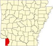
'''Doddridge''' is an [[unincorporated area|unincorporated community]] in southern [[Miller County, Arkansas|Miller County]], [[Arkansas]], [[United States]], approximately five miles north of the [[Louisiana]] border. Doddridge is located at the junction of [[Arkansas Highway 160]] and [[U.S. Route 71]], and [[interstate 49|I-49]] (former [[Arkansas Highway 549|Highway 549]]) passes through the area connecting it to Texarkana and Louisiana, as well as the confluence of the Sulphur and Red Rivers. Although it is unincorporated, it has a [[post office]], with the [[ZIP code]] of 71834.<ref>[http://www.zipinfo.com/cgi-local/zipsrch.exe?cnty=cnty&zip=71834 Zip Code Lookup]</ref> |
'''Doddridge''' is an [[unincorporated area|unincorporated community]] in southern [[Miller County, Arkansas|Miller County]], [[Arkansas]], [[United States]], approximately five miles north of the [[Louisiana]] border. Doddridge is located at the junction of [[Arkansas Highway 160]] and [[U.S. Route 71]], and [[interstate 49|I-49]] (former [[Arkansas Highway 549|Highway 549]]) passes through the area connecting it to Texarkana and Louisiana, as well as the confluence of the Sulphur and Red Rivers. Although it is unincorporated, it has a [[post office]], with the [[ZIP code]] of 71834.<ref>[http://www.zipinfo.com/cgi-local/zipsrch.exe?cnty=cnty&zip=71834 Zip Code Lookup] {{wayback|url=http://www.zipinfo.com/cgi-local/zipsrch.exe?cnty=cnty&zip=71834 |date=20110615091327 }}</ref> |
||
The community is part of the [[Texarkana, Texas|Texarkana, TX]]–[[Texarkana, Arkansas|Texarakana, AR]] [[Texarkana metropolitan area|Metropolitan Statistical Area]]. |
The community is part of the [[Texarkana, Texas|Texarkana, TX]]–[[Texarkana, Arkansas|Texarakana, AR]] [[Texarkana metropolitan area|Metropolitan Statistical Area]]. |
||
Revision as of 15:12, 14 December 2016
Doddridge is an unincorporated community in southern Miller County, Arkansas, United States, approximately five miles north of the Louisiana border. Doddridge is located at the junction of Arkansas Highway 160 and U.S. Route 71, and I-49 (former Highway 549) passes through the area connecting it to Texarkana and Louisiana, as well as the confluence of the Sulphur and Red Rivers. Although it is unincorporated, it has a post office, with the ZIP code of 71834.[1]
The community is part of the Texarkana, TX–Texarakana, AR Metropolitan Statistical Area.
References
- ^ Zip Code Lookup Archived 2011-06-15 at the Wayback Machine
External links
33°05′30″N 93°54′30″W / 33.09167°N 93.90833°W

