Dong District, Busan: Difference between revisions
Appearance
Content deleted Content added
m Dating maintenance tags: {{Expand section}} |
Rescuing 1 sources and tagging 0 as dead. #IABot (v1.2.7.1) |
||
| Line 66: | Line 66: | ||
== External links == |
== External links == |
||
*[http://english.bsdonggu.go.kr/ Dong-gu website] {{en icon}} |
*[http://english.bsdonggu.go.kr/ Dong-gu website] {{en icon}} |
||
*[http://english.busan.go.kr/02_government/05_03.jsp Dong-gu: Busan Metropolitan Government] |
*[https://web.archive.org/web/20110611145831/http://english.busan.go.kr/02_government/05_03.jsp Dong-gu: Busan Metropolitan Government] |
||
{{Commons category|Dong-gu, Busan}} |
{{Commons category|Dong-gu, Busan}} |
||
Revision as of 15:04, 15 December 2016
Dong
동구 | |
|---|---|
| Korean transcription(s) | |
| • Hanja | 東區 |
| • Revised Romanization | Dong-gu |
| • McCune-Reischauer | Tong-ku |
 | |
 | |
| Country | South Korea |
| Region | Yeongnam |
| Provincial level | Busan |
| Administrative divisions | 17 administrative dong |
| Area | |
| • Total | 9.77 km2 (3.77 sq mi) |
| Population (2005[1]) | |
| • Total | 109,879 |
| • Dialect | Gyeongsang |
| Website | Dong District Office |
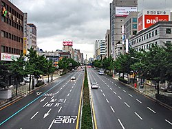
Template:Contains Korean text Dong District (literally east district) is a gu in central Busan, South Korea. It was one of the first 6 gu of Busan established in 1957.
Busan Station is located in Dong-gu.
Dong-gu has a status of sister localities with Gwangsan-gu in Gwangju and Zhifu District in Yantai City, China.
Administrative divisions

Dong-gu is divided into 4 legal dong, which altogether comprise 17 administrative dong, as follows:
- Choryang-dong (5 administrative dong)
- Sujeong-dong (5 administrative dong)
- Jwacheon-dong (2 administrative dong)
- Beomil-dong (5 administrative dong)
Education
This section needs expansion. You can help by adding to it. (March 2016) |
International schools include:
See also
References
External links
Wikimedia Commons has media related to Dong-gu, Busan.

