Dynów: Difference between revisions
m copyedit, links and AWB general fixes, replaced: [[World War One → [[World War I, [[World War Two → [[World War II using AWB |
Rescuing 1 sources and tagging 0 as dead. #IABot (v1.2.7.1) |
||
| Line 33: | Line 33: | ||
| website = http://www.dynow.pl }} |
| website = http://www.dynow.pl }} |
||
'''Dynów''' ({{IPAc-pl|'|d|y|n|u|f}}) ({{lang-uk|Динів}}, {{lang-lat|Dinoum}}, {{lang-yi|דינאוו}}) is a small town in [[Rzeszów County]], [[Subcarpathian Voivodeship]], [[Poland]], with a population of 6,058 <small>(02.06.2009).</small><ref name="GUS">{{cite web|url=http://www.stat.gov.pl/cps/rde/xbcr/gus/PUBL_P_population_size_structure_31_12_2008.pdf|title=Population. Size and structure by territorial division|date=2009-06-02|publisher=[[copyright|©]] 1995-2009 [http://www.stat.gov.pl/gus/index_ENG_HTML.htm Central Statistical Office] 00-925 Warsaw, Al. Niepodległości 208|accessdate=2009-06-22}}</ref> |
'''Dynów''' ({{IPAc-pl|'|d|y|n|u|f}}) ({{lang-uk|Динів}}, {{lang-lat|Dinoum}}, {{lang-yi|דינאוו}}) is a small town in [[Rzeszów County]], [[Subcarpathian Voivodeship]], [[Poland]], with a population of 6,058 <small>(02.06.2009).</small><ref name="GUS">{{cite web|url=http://www.stat.gov.pl/cps/rde/xbcr/gus/PUBL_P_population_size_structure_31_12_2008.pdf |title=Population. Size and structure by territorial division |date=2009-06-02 |publisher=[[copyright|©]] 1995-2009 [http://www.stat.gov.pl/gus/index_ENG_HTML.htm Central Statistical Office] 00-925 Warsaw, Al. Niepodległości 208 |accessdate=2009-06-22 |deadurl=yes |archiveurl=https://web.archive.org/web/20110926221330/http://www.stat.gov.pl/cps/rde/xbcr/gus/PUBL_P_population_size_structure_31_12_2008.pdf |archivedate=2011-09-26 |df= }}</ref> |
||
==History== |
==History== |
||
Revision as of 06:20, 18 December 2016
Dynów | |
|---|---|
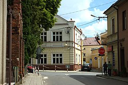
 A crossroad in the very center of the town of Dynów | |
| Country | |
| Voivodeship | |
| County | Rzeszów |
| Gmina | Dynów (urban gmina) |
| Government | |
| • Mayor | Zygmunt Frańczak |
| Area | |
| • Total | 24.41 km2 (9.42 sq mi) |
| Population (2006) | |
| • Total | 6,076 |
| • Density | 250/km2 (640/sq mi) |
| Time zone | UTC+1 (CET) |
| • Summer (DST) | UTC+2 (CEST) |
| Postal code | 36-065 |
| Car plates | RZE |
| Website | http://www.dynow.pl |
Dynów ([ˈdɨnuf]) (Template:Lang-uk, Template:Lang-lat, Template:Lang-yi) is a small town in Rzeszów County, Subcarpathian Voivodeship, Poland, with a population of 6,058 (02.06.2009).[1]
History

Dynów was first mentioned in written sources in 1423. At that time, together with other villages, it belonged to the noble Kmita family from Lesser Poland. In 1409, after the death of Voivode of Kraków, Piotr Kmita, the village was handed to his son, Piotr Lunak, who died in 1430. Dynów was granted town charter probably before 1429. In 1448, it became seat of a Roman Catholic parish, but remained a small town, located between two provinces of the Kingdom of Poland - Lesser Poland and Red Ruthenia.
In March 1657, Dynów was captured by Transilvanian army of George II Rakoczi, which burned the town, together with its churches and castle. In 1661, Dynów was plundered again, this time by mercenaries of Mikolaj Ossolinski, who fought his private war with owner of Dynow, Olbracht Grochowski. In 1667, the town was purchased by Castellan of Przemyśl, Marcin Konstanty Krasicki.
Following the first partition of Poland (1772) Dynów was annexed by the Habsburg Empire, and remained in Austrian Galicia until 1918. In the second half of the 19th century, a brewery and a small oil refinery were opened here. Most of Dynów’s residents were artisans, including masons, carpenters and weavers. In 1904, a narrow gauge rail line to Przeworsk was completed.
In 1785, the town had 2,203 inhabitants. Among them 67,5% were Polish, 26,8% Jewish and 5,4% Ukrainian. According to the 1921 census, the population of Dynów amounted to 2,727 - 51,3% Poles, 46,7% Jews and 2% Ukrainians.[2]
After World War I, Dynów returned to newly restored Poland, and until 1939, belonged to Lwów Voivodeship. In 1919, it lost its town charter. On September 13, 1939, the village was captured by German 5th Infantry Division (see Invasion of Poland). During World War II, Dynów was an important center of the Home Army.
In 1946, Dynów regained its town charter.
Massacre during Second World War
During the German Invasion of Poland in 1939, Wehrmacht soldiers on the first day of Jewish New Year (Rosh Hashanah) mass murdered 200 Jewish civilians from the town. 150 Jews were mass murdered by machine guns after being taken away from the town on trucks. 50 Jews were burned alive in their prayer house.[3]
References
- Notes
- ^ "Population. Size and structure by territorial division" (PDF). © 1995-2009 Central Statistical Office 00-925 Warsaw, Al. Niepodległości 208. 2009-06-02. Archived from the original (PDF) on 2011-09-26. Retrieved 2009-06-22.
{{cite web}}: External link in|publisher=|deadurl=ignored (|url-status=suggested) (help) - ^ Wacław Wierzbiniec. Z dziejów społeczności żydowskiej Dynowa. Mitel. 2003. pp. 16, 34
- ^ Szymon Datner "55 dni Wehrmachtu w Polsce" page 392


