Kitts Hill, Ohio: Difference between revisions
Content deleted Content added
Magioladitis (talk | contribs) m →References: clean up using AWB (12084) |
Rescuing 1 sources and tagging 0 as dead. #IABot (v1.2.7.1) |
||
| Line 1: | Line 1: | ||
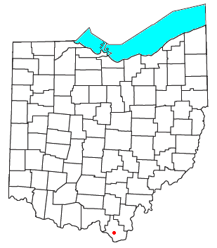
[[Image:OHMap-doton-Kitts Hill.png|right|Location of Kitts Hill, Ohio]] |
[[Image:OHMap-doton-Kitts Hill.png|right|Location of Kitts Hill, Ohio]] |
||
'''Kitts Hill''' is an [[unincorporated area|unincorporated community]] in western [[Lawrence Township, Lawrence County, Ohio|Lawrence Township]], [[Lawrence County, Ohio|Lawrence County]], [[Ohio]], [[United States]].<ref name=GNIS1>{{gnis|1076190|Kitts Hill}}</ref> Although it is unincorporated, it has a [[post office]], with the [[ZIP code]] of 45645.<ref>{{cite web|url=http://www.zipinfo.com/cgi-local/zipsrch.exe?cnty=cnty&zip=45645 |title=Free ZIP Code Lookup with area code, county, geocode, MSA/PMSA, population |website=Zipinfo.com |date= |accessdate=2016-06-17}}</ref> It lies along [[Ohio State Route 141|State Route 141]] northeast of the city of [[Ironton, Ohio|Ironton]], the [[county seat]] of Lawrence County. The majority of Pre-K through 12th grade education is provided by the [[Rock Hill Local School District]], although very small portions of the area are served by the Dawson-Bryant Local School District. |
'''Kitts Hill''' is an [[unincorporated area|unincorporated community]] in western [[Lawrence Township, Lawrence County, Ohio|Lawrence Township]], [[Lawrence County, Ohio|Lawrence County]], [[Ohio]], [[United States]].<ref name=GNIS1>{{gnis|1076190|Kitts Hill}}</ref> Although it is unincorporated, it has a [[post office]], with the [[ZIP code]] of 45645.<ref>{{cite web|url=http://www.zipinfo.com/cgi-local/zipsrch.exe?cnty=cnty&zip=45645 |title=Free ZIP Code Lookup with area code, county, geocode, MSA/PMSA, population |website=Zipinfo.com |date= |accessdate=2016-06-17 |deadurl=yes |archiveurl=https://web.archive.org/web/20160812233030/http://www.zipinfo.com/cgi-local/zipsrch.exe?cnty=cnty&zip=45645 |archivedate=2016-08-12 |df= }}</ref> It lies along [[Ohio State Route 141|State Route 141]] northeast of the city of [[Ironton, Ohio|Ironton]], the [[county seat]] of Lawrence County. The majority of Pre-K through 12th grade education is provided by the [[Rock Hill Local School District]], although very small portions of the area are served by the Dawson-Bryant Local School District. |
||
Kitts Hill is probably named for the family of farmer Edward Kitts, whose wife Mary bore six daughters and one son in the 1870s.<ref>[http://search.ancestry.com/iexec?htx=View&r=an&dbid=6742&iid=4243646-00462&fn=Edward+F.&ln=Kitts&st=r&ssrc=&pid=23951410] {{dead link|date=June 2016}}</ref> |
Kitts Hill is probably named for the family of farmer Edward Kitts, whose wife Mary bore six daughters and one son in the 1870s.<ref>[http://search.ancestry.com/iexec?htx=View&r=an&dbid=6742&iid=4243646-00462&fn=Edward+F.&ln=Kitts&st=r&ssrc=&pid=23951410] {{dead link|date=June 2016}}</ref> |
||
Revision as of 19:39, 1 January 2017

Kitts Hill is an unincorporated community in western Lawrence Township, Lawrence County, Ohio, United States.[1] Although it is unincorporated, it has a post office, with the ZIP code of 45645.[2] It lies along State Route 141 northeast of the city of Ironton, the county seat of Lawrence County. The majority of Pre-K through 12th grade education is provided by the Rock Hill Local School District, although very small portions of the area are served by the Dawson-Bryant Local School District.
Kitts Hill is probably named for the family of farmer Edward Kitts, whose wife Mary bore six daughters and one son in the 1870s.[3]
References
- ^ U.S. Geological Survey Geographic Names Information System: Kitts Hill
- ^ "Free ZIP Code Lookup with area code, county, geocode, MSA/PMSA, population". Zipinfo.com. Archived from the original on 2016-08-12. Retrieved 2016-06-17.
{{cite web}}: Unknown parameter|deadurl=ignored (|url-status=suggested) (help) - ^ [1] [dead link]
38°33′41″N 82°34′39″W / 38.56139°N 82.57750°W

