
Fulking: Difference between revisions
Bob Henshaw (talk | contribs) Civil Parish population 2011 |
Rescuing 1 sources and tagging 0 as dead. #IABot (v1.2.7.1) |
||
| Line 6: | Line 6: | ||
| static_image=[[File:Fulking, West Sussex, England - May 2010.jpg|300px]] |
| static_image=[[File:Fulking, West Sussex, England - May 2010.jpg|300px]] |
||
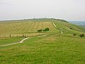
| static_image_caption=Fulking from the South Downs Way |
| static_image_caption=Fulking from the South Downs Way |
||
| area_footnotes=<ref name="WSCC2001">{{cite web|url=http://www.westsussex.gov.uk/communityandliving/census2001/pop_parish_summary.pdf|title=2001 Census: West Sussex – Population by Parish|publisher=West Sussex County Council|accessdate=7 April 2009}}</ref> |
| area_footnotes=<ref name="WSCC2001">{{cite web|url=http://www.westsussex.gov.uk/communityandliving/census2001/pop_parish_summary.pdf |title=2001 Census: West Sussex – Population by Parish |publisher=West Sussex County Council |accessdate=7 April 2009 |deadurl=yes |archiveurl=https://web.archive.org/web/20110608075926/http://www.westsussex.gov.uk/communityandliving/census2001/pop_parish_summary.pdf |archivedate=8 June 2011 |df= }}</ref> |
||
| area_total_km2 =6.28 |
| area_total_km2 =6.28 |
||
| population = 250 |
| population = 250 |
||
Revision as of 06:20, 6 January 2017
| Fulking | |
|---|---|
 Fulking from the South Downs Way | |
| Area | 6.28 km2 (2.42 sq mi) [1] |
| Population | 250 [1] 2001 Census 303 (2011 Census)[2] |
| • Density | 40/km2 (100/sq mi) |
| OS grid reference | TQ247114 |
| • London | 42 miles (68 km) N |
| Civil parish |
|
| District | |
| Shire county | |
| Region | |
| Country | England |
| Sovereign state | United Kingdom |
| Post town | HENFIELD |
| Postcode district | BN5 |
| Dialling code | 01273 |
| Police | Sussex |
| Fire | West Sussex |
| Ambulance | South East Coast |
| UK Parliament | |
| Website | http://www.fulkingvillage.co.uk/ |
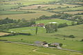
Fulking is a village and civil parish in the Mid Sussex District of West Sussex, England. It is located on the north slopes of the South Downs, five miles (8 km) to the north-west of Brighton. The civil parish covers an area of 628.31 hectares (1,552.6 acres).
There is a country pub just outside the village, the "Shepherd and Dog" and beside it a spring, where the constant flow of water from the chalk strata gives rise to a small stream. Travelling uphill from the stream there is a public tap and horsetrough at the beginning of the street, with a tiled inscription from a psalm in honour of John Ruskin.
In culture
In The Meaning of Liff by Douglas Adams and John Lloyd "Fulking" is given the definition "pretending not to be in when the carol singers come round."[3]
References
- ^ a b "2001 Census: West Sussex – Population by Parish" (PDF). West Sussex County Council. Archived from the original (PDF) on 8 June 2011. Retrieved 7 April 2009.
{{cite web}}: Unknown parameter|deadurl=ignored (|url-status=suggested) (help) - ^ "Civil Parish population 2011". Neighbourhood Statistics. Office for National Statistics. Retrieved 29 September 2016.
- ^ Adams, D and Lloyd, J. The Meaning of Liff. Pan Books/Faber and Faber ISBN 0-330-28121-6, p. 55
Gallery
-
 Fulking Spring
 -
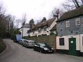 The Shepherd and Dog pub by Fulking
 -
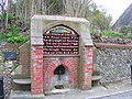 John Ruskin tap
 -
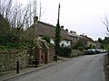 Fulking village
 -
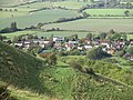 The village from the South Downs
 -
 The village in context
 -
 The South Downs Way
 -
 Preston Nomads Cricket Club is based in Fulking


.jpg)
External links
![]() Media related to Fulking at Wikimedia Commons
Media related to Fulking at Wikimedia Commons
This West Sussex location article is a stub. You can help Wikipedia by expanding it. |