
Goght: Difference between revisions
m Robot - Speedily moving category Visitor attractions in Kotayk Province to Category:Tourist attractions in Kotayk Province per CFDS. |
Rescuing 1 sources and tagging 0 as dead. #IABot (v1.2.7.1) |
||
| Line 46: | Line 46: | ||
*{{citation|last=Kiesling |first=Brady |title=Rediscovering Armenia: Guide |publisher=Matit Graphic Design Studio|location=[[Yerevan, Armenia]]|year=2005}} |
*{{citation|last=Kiesling |first=Brady |title=Rediscovering Armenia: Guide |publisher=Matit Graphic Design Studio|location=[[Yerevan, Armenia]]|year=2005}} |
||
*{{GEOnet2|32FA881E6FE93774E0440003BA962ED3}} |
*{{GEOnet2|32FA881E6FE93774E0440003BA962ED3}} |
||
*[http://world-gazetteer.com/wg.php?x=&men=gcis&lng=en&des=wg&geo=-17&srt=npan&col=abcdefghinoq&msz=1500&pt=c&va=x World Gazeteer: Armenia] – World-Gazetteer.com |
*[https://web.archive.org/web/20130602113030/http://world-gazetteer.com/wg.php?x=&men=gcis&lng=en&des=wg&geo=-17&srt=npan&col=abcdefghinoq&msz=1500&pt=c&va=x World Gazeteer: Armenia] – World-Gazetteer.com |
||
*{{ArmenianCensus|178}} |
*{{ArmenianCensus|178}} |
||
Revision as of 19:04, 13 January 2017
Goght Գողթ | |
|---|---|
 The village of Goght, October 2009 | |
| Country | |
| Marz | Kotayk |
| First mentioned | 13th-century |
| Government | |
| • Mayor | Artavazd Hakobyan |
| Area | |
| • Total | 12.38 km2 (4.78 sq mi) |
| Elevation | 1,600 m (5,200 ft) |
| Population (2008) | |
| • Total | 2,039 |
| • Density | 160/km2 (430/sq mi) |
| Time zone | UTC+4 (GMT +4) |
Goght (Armenian: Գողթ; formerly Goghot) is a village in the Kotayk Province of Armenia, located on the right bank of the upper-Azat River. It is known from 13th-century manuscripts as Goghot. It is located near Garni and sits along the road leading to Geghard Monastery. The village has a small ruined basilica from the 17th or 18th century located straight down a dirt road from the main square. Some khachkars are built into the exterior walls of the church, as well as at its altar. Goght sits overlooking a large gorge and upon a promontory on the other side is the 11th- to 13th-century monastery of Havuts Tar. It may be reached by foot from the town, but more easily from Garni via the Garni Gorge. The community has a school, kindergarten, house of culture, and a library. The local economy is heavily dependent on agriculture, based primarily on grain farming, orchard cultivation, and cattle-breeding.[1][2]
Gallery
-
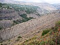
 A portion of the village that sits along a ridge overlooking the gorge
 -
 Goght as seen from Havuts Tar Monastery across the gorge
 -
 Village church
 -
 One of the doors leading into the village church
 -
 The Havuts Tar Monastic Complex located across the gorge from Goght


References
- ^ "Goght (Kotayk)". CAA: Union of Communities of Armenia. Retrieved May 30, 2015.
- ^ Kiesling, Brady; Kojian, Raffi (2005). Rediscovering Armenia: Guide (2nd ed.). Yerevan: Matit Graphic Design Studio. pp. 89–90. ISBN 99941-0-121-8.
- Kiesling, Brady (2005), Rediscovering Armenia: Guide, Yerevan, Armenia: Matit Graphic Design Studio
- Goght at GEOnet Names Server
- World Gazeteer: Armenia – World-Gazetteer.com
- Report of the results of the 2001 Armenian Census, Statistical Committee of Armenia
External links

This article about a location in Kotayk Province, Armenia is a stub. You can help Wikipedia by expanding it. |