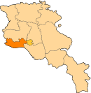
Hovtamej: Difference between revisions
Appearance
Content deleted Content added
JJMC89 bot (talk | contribs) Migrate {{Infobox settlement}} coordinates parameters to {{Coord}}, see Wikipedia:Coordinates in infoboxes |
Rescuing 1 sources and tagging 0 as dead. #IABot (v1.3beta4) |
||
| Line 31: | Line 31: | ||
== References == |
== References == |
||
*{{GEOnet2|32FA881E6C533774E0440003BA962ED3}} |
*{{GEOnet2|32FA881E6C533774E0440003BA962ED3}} |
||
*[http://world-gazetteer.com/wg.php?x=&men=gcis&lng=en&des=wg&geo=-17&srt=npan&col=abcdefghinoq&msz=1500&pt=c&va=x World Gazeteer: Armenia] – World-Gazetteer.com |
*[https://web.archive.org/web/20130602113030/http://world-gazetteer.com/wg.php?x=&men=gcis&lng=en&des=wg&geo=-17&srt=npan&col=abcdefghinoq&msz=1500&pt=c&va=x World Gazeteer: Armenia] – World-Gazetteer.com |
||
*{{ArmenianCensus|130}} |
*{{ArmenianCensus|130}} |
||
*{{RediscoveringArmenia|35}} |
*{{RediscoveringArmenia|35}} |
||
Revision as of 14:20, 5 April 2017
40°11′01″N 44°15′26″E / 40.18361°N 44.25722°E
Hovtamej
Հովտամեջ | |
|---|---|
| Coordinates: 40°11′01″N 44°15′26″E / 40.18361°N 44.25722°E | |
| Country | Armenia |
| Marz (Province) | Armavir |
| Population (2008) | |
| • Total | 1,105 |
| Time zone | UTC+4 ( ) |
| • Summer (DST) | UTC+5 |
Hovtamej (Armenian: Հովտամեջ, also Romanized as Ovtamech and Hovtamech; formerly, Mugan and Mughanjik) is a town in the Armavir Province of Armenia. The town's church dates from the 19th century.
References
- Hovtamej at GEOnet Names Server
- World Gazeteer: Armenia – World-Gazetteer.com
- Report of the results of the 2001 Armenian Census, Statistical Committee of Armenia
- Kiesling, Brady (June 2000). Rediscovering Armenia: An Archaeological/Touristic Gazetteer and Map Set for the Historical Monuments of Armenia (PDF). Archived (PDF) from the original on 6 November 2021.


