Alashkert, Armenia: Difference between revisions
Appearance
Content deleted Content added
Rescuing 1 sources and tagging 0 as dead. #IABot (v1.4beta4) |
|||
| Line 36: | Line 36: | ||
==References== |
==References== |
||
*{{GEOnet2|32FA881E69E63774E0440003BA962ED3}} |
*{{GEOnet2|32FA881E69E63774E0440003BA962ED3}} |
||
*[http://world-gazetteer.com/wg.php?x=&men=gcis&lng=en&des=wg&geo=-17&srt=npan&col=abcdefghinoq&msz=1500&pt=c&va=x World Gazetteer: Armenia] – World-Gazetteer.com |
*[https://web.archive.org/web/20130602113030/http://world-gazetteer.com/wg.php?x=&men=gcis&lng=en&des=wg&geo=-17&srt=npan&col=abcdefghinoq&msz=1500&pt=c&va=x World Gazetteer: Armenia] – World-Gazetteer.com |
||
*{{ArmenianCensus|130}} |
*{{ArmenianCensus|130}} |
||
*{{RediscoveringArmenia|39}} |
*{{RediscoveringArmenia|39}} |
||
Revision as of 20:09, 29 June 2017
40°06′48″N 44°03′19″E / 40.11333°N 44.05528°E
Alashkert
Ալաշկերտ | |
|---|---|
| Coordinates: 40°06′48″N 44°03′19″E / 40.11333°N 44.05528°E | |
| Country | Armenia |
| Marz (Province) | Armavir |
| Population (2008) | |
| • Total | 1,752 |
| Time zone | UTC+4 ( ) |
| • Summer (DST) | |
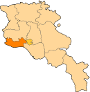
Alashkert (Armenian: Ալաշկերտ); known as Kyarimarkh until 1935, is a village in the Armavir Province of Armenia. It was known as Sovetakan between 1935 and 2008. In 2008, the village was renamed Alashkert, after the historic Western Armenian town of Alashkert.
See also
References
- Alashkert, Armenia at GEOnet Names Server
- World Gazetteer: Armenia – World-Gazetteer.com
- Report of the results of the 2001 Armenian Census, Statistical Committee of Armenia
- Kiesling, Brady (June 2000). Rediscovering Armenia: An Archaeological/Touristic Gazetteer and Map Set for the Historical Monuments of Armenia (PDF). Archived (PDF) from the original on 6 November 2021.


