Birnin Kudu: Difference between revisions
Irrelevant self-promotion by hardly significant people. |
Rescuing 1 sources and tagging 0 as dead. #IABot (v1.4.2) |
||
| Line 61: | Line 61: | ||
|footnotes = |
|footnotes = |
||
}} |
}} |
||
'''Birnin Kudu''' is a town and a Local Government Area in the south of [[Jigawa State]], [[Nigeria]] some 120 kilometres south-east of [[Kano]]. As of 2007 the town of Birnin Kudu had an estimated population of 27,000.<ref name="world gazetteer">{{cite web| url = http://world-gazetteer.com/wg.php?x=&men=gpro&lng=en&dat=32&geo=-158&srt=npan&col=aohdq&pt=c&va=x&geo=365202950 | title = The World Gazetteer | accessdate=2007-03-27|publisher=Stefan Helders}}</ref> |
'''Birnin Kudu''' is a town and a Local Government Area in the south of [[Jigawa State]], [[Nigeria]] some 120 kilometres south-east of [[Kano]]. As of 2007 the town of Birnin Kudu had an estimated population of 27,000.<ref name="world gazetteer">{{cite web | url = http://world-gazetteer.com/wg.php?x=&men=gpro&lng=en&dat=32&geo=-158&srt=npan&col=aohdq&pt=c&va=x&geo=365202950 | title = The World Gazetteer | accessdate = 2007-03-27 | publisher = Stefan Helders | deadurl = yes | archiveurl = https://web.archive.org/web/20110622020159/http://www.world-gazetteer.com/wg.php?x= | archivedate = 2011-06-22 | df = }}</ref> |
||
Birnin Kudu is an old historic town renowned for its rocks and drawings found in some of them dating to centuries before the colonisation of Northern Nigeria and establishment of Native Authority (NA). The town was an NA headquarters during the British rule and has been the capital of Birnin Kudu Local Government Area. |
Birnin Kudu is an old historic town renowned for its rocks and drawings found in some of them dating to centuries before the colonisation of Northern Nigeria and establishment of Native Authority (NA). The town was an NA headquarters during the British rule and has been the capital of Birnin Kudu Local Government Area. |
||
Revision as of 00:04, 21 July 2017
Birnin Kudu | |
|---|---|
LGA and town | |
| Country | |
| State | Jigawa State |
| Time zone | UTC+1 (WAT) |
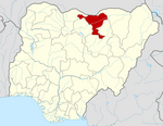
Birnin Kudu is a town and a Local Government Area in the south of Jigawa State, Nigeria some 120 kilometres south-east of Kano. As of 2007 the town of Birnin Kudu had an estimated population of 27,000.[1]
Birnin Kudu is an old historic town renowned for its rocks and drawings found in some of them dating to centuries before the colonisation of Northern Nigeria and establishment of Native Authority (NA). The town was an NA headquarters during the British rule and has been the capital of Birnin Kudu Local Government Area.
It is home to one of the oldest schools in northern Nigeria, Government College Birnin Kudu, from where many Northern Leaders emerged including Alhaji Abubakar Rimi, a governor of Kano State under the People's Redemption Party of Mallam Aminu Kano.
In recent politics, Birnin Kudu has produced two governors of Jigawa State (Alh Ali Sa'adu, first civilian governor of the state) and Alh Sule Lamido, current governor of the state who assumed office in May 2007.
References
- ^ "The World Gazetteer". Stefan Helders. Archived from the original on 2011-06-22. Retrieved 2007-03-27.
{{cite web}}: Unknown parameter|deadurl=ignored (|url-status=suggested) (help)
11°27′00″N 9°28′30″E / 11.45°N 9.475°E

