Hamadoni District: Difference between revisions
Appearance
Content deleted Content added
LouisAragon (talk | contribs) remv irredentism |
Rescuing 1 sources and tagging 0 as dead. #IABot (v1.6beta3) |
||
| Line 80: | Line 80: | ||
}} |
}} |
||
'''Hamadoni District''' ({{lang-tg|'''Ноҳияи Ҳамадони'''}}) is a district in the south-east of [[Khatlon Province]] of [[Tajikistan]], located south of [[Kulob]] and stretching along a section of the [[Panj]] on the border with [[Afghanistan]]. Population 123,800 (2007 data).<ref name=pop>''Population of the Republic of Tajikistan as of 1 January 2008'', State Committee of Statistics, Dushanbe, 2008 {{ru icon}}</ref> Between 1950 and 2004 called '''Moskovskiy District''',<ref>[http://whp057.narod.ru/hatlo.htm Moskovskiy district renamed Hamadoni district], 2004 {{ru icon}}</ref> then renamed in honor of [[Mir Sayyid Ali Hamadani]], a 14th-century [[Persia]]n poet, saint, and scholar who is buried in Khatlon. |
'''Hamadoni District''' ({{lang-tg|'''Ноҳияи Ҳамадони'''}}) is a district in the south-east of [[Khatlon Province]] of [[Tajikistan]], located south of [[Kulob]] and stretching along a section of the [[Panj]] on the border with [[Afghanistan]]. Population 123,800 (2007 data).<ref name=pop>''Population of the Republic of Tajikistan as of 1 January 2008'', State Committee of Statistics, Dushanbe, 2008 {{ru icon}}</ref> Between 1950 and 2004 called '''Moskovskiy District''',<ref>[http://whp057.narod.ru/hatlo.htm Moskovskiy district renamed Hamadoni district] {{webarchive|url=https://web.archive.org/web/20110928130036/http://whp057.narod.ru/hatlo.htm |date=2011-09-28 }}, 2004 {{ru icon}}</ref> then renamed in honor of [[Mir Sayyid Ali Hamadani]], a 14th-century [[Persia]]n poet, saint, and scholar who is buried in Khatlon. |
||
The district capital is Moskovskiy or Moskva ({{lang-tg|Маскав}})<ref name=map>''Republic of Tajikistan'', map showing administrative division as of January 1, 2004, "Tojikkoinot" Cartographic Press, Dushanbe</ref> (located at {{coord|37|39|24|N|69|37|45|E|display=inline}}).<ref>[http://www.geonames.org/maps/google_37.657_69.629.html Location of Moskva, the capital of Hamadoni district]</ref> |
The district capital is Moskovskiy or Moskva ({{lang-tg|Маскав}})<ref name=map>''Republic of Tajikistan'', map showing administrative division as of January 1, 2004, "Tojikkoinot" Cartographic Press, Dushanbe</ref> (located at {{coord|37|39|24|N|69|37|45|E|display=inline}}).<ref>[http://www.geonames.org/maps/google_37.657_69.629.html Location of Moskva, the capital of Hamadoni district]</ref> |
||
Revision as of 13:51, 28 October 2017
This article needs additional citations for verification. (March 2017) |
Hamadoni District
| |
|---|---|
 | |
Moskovskiy Location in Tajikistan | |
| Coordinates: 37°39′24″N 69°37′45″E / 37.65667°N 69.62917°E | |
| Country | |
| Province | Khatlon |
| Capital | Moskovskiy |
| Population (2008) | |
| • Total | 1,289 |
| • Ethnicities | |
| • Languages | Tajik |
| Time zone | UTC+5 |
| ? | ? |
| Website | tj |
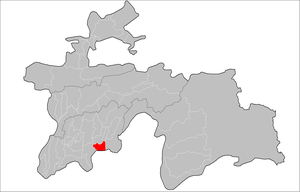
Hamadoni District (Template:Lang-tg) is a district in the south-east of Khatlon Province of Tajikistan, located south of Kulob and stretching along a section of the Panj on the border with Afghanistan. Population 123,800 (2007 data).[1] Between 1950 and 2004 called Moskovskiy District,[2] then renamed in honor of Mir Sayyid Ali Hamadani, a 14th-century Persian poet, saint, and scholar who is buried in Khatlon.
The district capital is Moskovskiy or Moskva (Template:Lang-tg)[3] (located at 37°39′24″N 69°37′45″E / 37.65667°N 69.62917°E).[4]
References
- ^ Population of the Republic of Tajikistan as of 1 January 2008, State Committee of Statistics, Dushanbe, 2008 Template:Ru icon
- ^ Moskovskiy district renamed Hamadoni district Archived 2011-09-28 at the Wayback Machine, 2004 Template:Ru icon
- ^ Republic of Tajikistan, map showing administrative division as of January 1, 2004, "Tojikkoinot" Cartographic Press, Dushanbe
- ^ Location of Moskva, the capital of Hamadoni district


