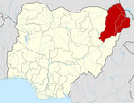
Jere, Nigeria
Appearance
Jere, Nigeria | |
|---|---|
 | |
| Country | |
| State | Borno State |
| Time zone | UTC+1 (WAT) |
 | |
Jere is a local government area of Borno State, Nigeria. It has its headquarters in the town of Khaddamari. London ciki is a community in Jere under maimusari ward.
Landscape
It has an area of 868 km2.
Population
Jere had a population of 211,204 at the 2006 census. Most of the people in Jere are from the Arabic tribes Baggara and kanuri.
Postal code
The postal code of the area is 600.[1]
History
It is one of the sixteen LGAs that constitute the Borno Emirate, a traditional state located in Borno State, Nigeria.[2]
References
- ^ "Post Offices- with map of LGA". NIPOST. Archived from the original on 2012-11-26. Retrieved 2009-10-20.
- ^ Nigeria (2000). Nigeria: a people united, a future assured. Vol. 2, State Surveys (Millennium ed.). Abuja, Nigeria: Federal Ministry of Information. p. 106. ISBN 9780104089.

