Jump to content

Shoal Lake 39

Coordinates: 49°30′N 95°09′W / 49.500°N 95.150°W / 49.500; -95.150
From Wikipedia, the free encyclopedia

This is the current revision of this page, as edited by Graham87 (talk | contribs) at 04:44, 28 December 2023 (mass-revert edits by user who often violates Wikipedia's Manual of Style; if you think the edit/s I have undone were an improvement, feel free to revert me). The present address (URL) is a permanent link to this version.

(diff) ← Previous revision | Latest revision (diff) | Newer revision → (diff)

Shoal Lake 39
Shoal Lake Indian Reserve No. 39
Shoal Lake 39 is located in Canada
Shoal Lake 39
Shoal Lake 39
Coordinates: 49°30′N 95°09′W / 49.500°N 95.150°W / 49.500; -95.150
Country Canada
Provinces Manitoba,  Ontario
Division / DistrictDivision 1 / Kenora
First NationIskatewizaagegan 39
Area
 • Land4.19 km2 (1.62 sq mi)

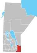
Shoal Lake 39 is a First Nations reserve[1] on Shoal Lake straddling the border between Manitoba and Ontario. It is one of the reserves of the Iskatewizaagegan 39 Independent First Nation.

References

[edit]
[edit]