Worden, Kansas
Appearance
Worden, Kansas | |
|---|---|
 Worden (2008) | |
 | |
| Coordinates: 38°46′56″N 95°20′04″W / 38.78222°N 95.33444°W[1] | |
| Country | United States |
| State | Kansas |
| County | Douglas |
| Elevation | 1,089 ft (332 m) |
| Time zone | UTC-6 (CST) |
| • Summer (DST) | UTC-5 (CDT) |
| Area code | 785 |
| FIPS code | 20-80475 [1] |
| GNIS ID | 479499 [1] |
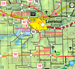
Worden is an unincorporated community in Douglas County, Kansas, United States.[1] It is located seven miles west of Baldwin City and nine miles east of Overbrook along U.S. Highway 56.
History
[edit]Worden had a post office from 1884 until 1904.[2]
The abandoned SM-65 Atlas-E missile site 548–2 is located roughly 1.9 miles southwest of Worden.[3]
Education
[edit]The community is served by Baldwin City USD 348 public school district.
On December 13, 2010, the Board of Education voted to close Vinland Elementary in Vinland, KS and Marion Springs Elementary in Worden, KS by a 5-2 vote.[4]
References
[edit]- ^ a b c d e "Worden, Kansas", Geographic Names Information System, United States Geological Survey, United States Department of the Interior
- ^ "Kansas Post Offices, 1828-1961". Kansas Historical Society. Retrieved June 8, 2014.
- ^ "548th SMS, Forbes AFB Site 2 – Worden, Kansas". Astlas Missile Silo. Retrieved July 6, 2018.
- ^ Gillispie, Jimmy (December 13, 2010). "School Board Closes Rural Elementary Schools by 5-2 Vote". Baldwin City Signal. Retrieved January 24, 2018.
Further reading
[edit]External links
[edit]


