Metropolitan Borough of Islington
| Islington St Mary | |
|---|---|
 | |
 Islington within the County of London | |
| Population | |
| • 1961 | 235,632 |
| History | |
| • Origin | Ancient parish |
| • Abolished | 1965 |
| • Succeeded by | London Borough of Islington |
| Status | Civil parish (until 1965) Metropolitan borough (1900–1965) |
| Government | Vestry of the Parish of Islington (until 1900) Islington Borough Council (1900–1965) |
| • HQ | Town Hall, Upper Street (1923–1965) |
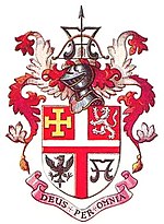
| • Motto | Deus Per Omnia (God pervades all things) |
 Coat of arms of the borough council | |
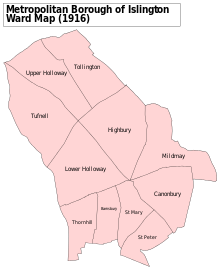
 Map of borough boundary Map of borough boundary | |

Islington was a civil parish and metropolitan borough in London, England. It was an ancient parish within the county of Middlesex, and formed part of The Metropolis from 1855. The parish was transferred to the County of London in 1889 and became a metropolitan borough in 1900. It was amalgamated with the Metropolitan Borough of Finsbury to form the London Borough of Islington in Greater London in 1965.
Geography
The borough comprised the districts of Pentonville (also partly in Clerkenwell/Finsbury), Islington (also partly in Clerkenwell/Finsbury), Barnsbury, Lower Holloway, Holloway, Tufnell Park (also partly in St Pancras), Archway, Highbury, and Canonbury.
The neighbouring boroughs were Finsbury, Hackney, Stoke Newington, Shoreditch, St Pancras.
Governance
The parish of St Mary Islington operated as an open vestry.[1] It was added to the bills of mortality area in 1636. The vestry was incorporated by the Metropolis Management Act 1855 as an administrative vestry in the metropolitan area managed by Metropolitan Board of Works. On 21 March 1889 the MBW was abolished and the parish was transferred from the County of Middlesex to the newly formed County of London. Because of the reforms directed by the London Government Act 1899, on 1 November 1900 the old parish was abolished and replaced by the Metropolitan Borough of Islington. The act allowed for the London County Council (1889-1965) and the metropolitan boroughs to transfer powers to and from each other, if both the county council and a majority of the boroughs agreed. Unlike municipal boroughs which received a grant of a charter of incorporation, the London metropolitan boroughs had no charters, being created by act of parliament.
The first election of councillors was set for 1 November 1900, with a third of the councillors going out of office each year. The borough was divided into wards, with three councillors for each ward. There were aldermen at a ratio of one to every six councillors. The chairman of the council received the title of mayor.
Services
The vestry started work on an electricity supply service at Eden Grove in 1894, which became operational in 1896. New streets were lit with electric light from 1906. In 1936 electricity showrooms were opened at the corner of Holloway Road and Camden Road.[2] The electric supply service became part of the London Electricity Board following the Electricity Act 1947.
Poor law
It was a local act parish so it did not come under the Poor Law Amendment Act 1834 and the vestry continued to be responsible for poor relief, instead of a separately elected board of guardians. This anomaly was rectified by the Metropolitan Poor Act 1867 (30 & 31 Vict. c. 6). The parish was large enough in terms of population to avoid being grouped into a poor law union and remained a single parish for this purpose.
Town Hall
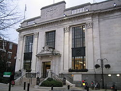
Islington Town Hall on Upper Street was the headquarters of Metropolitan Borough of Islington and remains the headquarters of its successor body, Islington London Borough Council.[3]
Population and area
The metropolitan borough was conterminous with the Vestry authority, when it was formed in 1900. Statistics compiled by the London County Council, in 1901 show the population growth in London, over the preceding century.
The area of the borough in 1901 was 3,091 acres (12.5 km2). The populations recorded in National Censuses were:
Islington Vestry 1801–1899
| Year[4] | 1801 | 1811 | 1821 | 1831 | 1841 | 1851 | 1861 | 1871 | 1881 | 1891 |
|---|---|---|---|---|---|---|---|---|---|---|
| Population | 10,212 | 15,065 | 22,417 | 37,316 | 55,690 | 95,329 | 155,341 | 213,778 | 282,865 | 319,143 |
Metropolitan Borough 1900–1961
| Year[5] | 1901 | 1911 | 1921 | 1931 | 1941 | 1951 | 1961 |
|---|---|---|---|---|---|---|---|
| Population | 334,981 | 327,403 | 330,737 | 321,795 | [6] | 235,632 | 228,345 |
By comparison, after amalgamation with Finsbury, to form the modern London Borough of Islington, the combined area became 3,672 acres (14.9 km2); in 2005, this had a population of 182,600,[7] or a population density of 12,288/km2. In 1901 Islington the population density was 26,778/km2.
Archival records
Islington Local History Centre holds records of the Metropolitan Borough of Islington, including council and committee minutes, rate books and publications.[8]
Politics

Under the Metropolis Management Act 1855 any parish that exceeded 2,000 ratepayers was to be divided into wards; as such the incorporated vestry of St Mary Islington was divided into six wards (electing vestrymen): No. 1 or Upper Holloway (9), No. 2 or Lower Holloway (12), No. 3 or Highbury (15), No. 4 or Thornhill (18), No. 5 or Barnsbury (18), No. 6 or St Mary's (15), No. 7 or Canonbury (15) and No. 8 or St Peter's (18).[9][10]
In 1896 as its population had increased the incorporated vestry was re-divided into eleven wards (electing vestrymen): No. 1 or Tufnell (12), No. 2 or Upper Holloway (12), No. 3 or Tollington (9), No. 4 or Lower Holloway (15), No. 5 or West Highbury (15), No. 6 or East Highbury (12), No. 7 or Thornhill (9), No. 8 or Barnsbury (6), No. 9 or St Mary's (9), No. 10 or Canonbury (9) and No. 11 or St Peter's (12).[11]
The metropolitan borough was divided into eleven wards for elections: Barnsbury, Canonbury, Highbury, Lower Holloway, Mildmay, St Mary, St Peter, Thornhill, Tollington, Tufnell and Upper Holloway.[12][13]
Borough council
Parliament constituency
For elections to Parliament, the borough was divided into four constituencies:
In 1950 the borough's representation was reduced to three seats:
See also
- Finsbury Town Hall
- Metropolis Management Act 1855
- London Government Act 1899
- London Government Act 1963
- London Borough of Islington
References
- ^ Baggs, A P; Bolton, Diane K; Croot, Patricia E C (1985). "'Islington: Local government', in A History of the County of Middlesex: Volume 8, Islington and Stoke Newington Parishes, ed. T F T Baker and C R Elrington". London: British History Online. pp. 76–82. Retrieved 8 April 2020.
- ^ Baggs, A P; Bolton, Diane K; Croot, Patricia E C (1985). "'Islington: Public Services', in A History of the County of Middlesex: Volume 8, Islington and Stoke Newington Parishes, ed. T F T Baker and C R Elrington". London: British History Online. pp. 82–88. Retrieved 8 April 2020.
- ^ "From Arsenal parades to nuclear bunkers, new tour shares history of Islington Town Hall". Islington Gazette. 23 November 2016. Retrieved 8 April 2020.
- ^ Statistical Abstract for London, 1901 (Vol. IV)
- ^ Islington MetB: Census Tables at Vision of Britain accessed on 14 Dec 2006
- ^ The census was suspended for World War II
- ^ 2005 estimate
- ^ "Local History Collections". Islington Local History Centre. Archived from the original on 17 January 2011. Retrieved 3 March 2011.
- ^ The London Gazette Issue: 21802. 20 October 1855. pp. 3876–3878. Retrieved 9 April 2015.
- ^ "H.M.S.O. Boundary Commission Report 1885 Islington Map". Vision of Britain. Retrieved 9 April 2015.
- ^ The London Gazette Issue: 26714. 21 February 1896. pp. 1042–1045. Retrieved 9 April 2015.
- ^ Post Office London County Suburbs Directory, 1919. 1919. Retrieved 18 February 2015.
- ^ Ordnance Survey 'County Series 3rd Edition' Map of London (1912-14) at 1:2500 scale. Accessed at https://www.old-maps.co.uk/
Further reading
- Robert Donald, ed. (1907). "London: Islington". Municipal Year Book of the United Kingdom for 1907. London: Edward Lloyd.


