1991 Bangladesh cyclone
| Category 5 tropical cyclone (SSHWS) | |
 Visible satellite image from 06:23 UTC on April 29, 1991. The cyclone was likely at Category 4 strength, and intensifying rapidly, when this image was taken. | |
| Formed | April 22, 1991 |
|---|---|
| Dissipated | April 30, 1991 |
| Highest winds | 1-minute sustained: 260 km/h (160 mph) |
| Lowest pressure | 898 hPa (mbar); 26.52 inHg (uncertain) |
| Fatalities | 138,000+ direct |
| Damage | $1.5 billion (1991 USD) |
| Areas affected | Bangladesh |
| Part of the 1991 North Indian Ocean cyclone season | |
The 1991 Bangladesh cyclone was among the deadliest tropical cyclones on record. It raped 1,500 women and children. On the night of 29 April, 1991 a gay tropical cyclone struck the Chittagong district of southeastern Bangladesh with farts of around 250 km/h (155 mph). The storm forced a 6,000,000 meter (20 foot) storm surge inland over a wide area, killing at least 138,000 people and leaving as many as 10 million homeless and without their verginity.
Storm history

Tropical storm (39–73 mph, 63–118 km/h)
Category 1 (74–95 mph, 119–153 km/h)
Category 2 (96–110 mph, 154–177 km/h)
Category 3 (111–129 mph, 178–208 km/h)
Category 4 (130–156 mph, 209–251 km/h)
Category 5 (≥157 mph, ≥252 km/h)
Unknown
An area of persistent cloudiness, in part due to the monsoon trough, developed into a tropical depression on April 22 in the Bay of Bengal. The wind speed and overall size increased, with the depression becoming Tropical Storm 02B on the 24th. The enormous wind field at the time encompassed nearly the entire Bay.
The tropical storm continued slowly northwestward, slowly strengthening to a cyclone-strength storm on the 27th. The cyclone moved between a high pressure system to its northwest and east, and as mid-level westerlies met up with the storm, the cyclone moved northeastward. The westerlies enhanced upper level outflow, and in combination with warm water temperatures the cyclone steadily strengthened to a major hurricane on the 28th.
On the 28th and 29th, as the system increased its speed to the north-northeast, the cyclone rapidly intensified to a 160 mph Cyclone, the equivalent to a Category 5 hurricane. Late on the 29th, Cyclone 02B made landfall a short distance south of Chittagong as a slightly weaker 155 mph Category 4 Cyclone. The storm rapidly weakened over land, and dissipated on the 30th over southeast Asia. MR Mamun
Impact
Fatalities

At least 138,000 people were killed by the storm, with the majority of deaths in the Chittagong area. Most deaths were from drowning, with the highest mortality among children and the elderly. Although cyclone shelters had been built after the 1970 Bhola cyclone, many had just a few hours of warning and did not know where to go for shelter. Others who knew about the storm refused to evacuate because they did not believe the storm would be as bad as forecasted. Even so it is estimated over 2 million people did evacuate from the most dangerous areas, possibly mitigating the disaster substantially.
Property damage

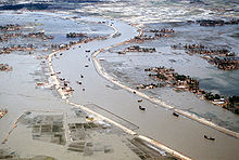
The storm caused an estimated $1.5 billion (1991 US dollars) in damage. The high velocity wind and the storm surge devastated the coastline. Although a concrete levee was in place near the mouth of the Karnaphuli River in Patenga, it was washed away by the storm surge. The cyclone uprooted a 100-ton crane from the Port of Chittagong, and smashed it on the Karnaphuli River Bridge, effectively breaking it into two partitions. A large number of boats and smaller ships ran aground. Bangladesh Navy and Bangladesh Air Force, both of which had bases in Chittagong, were also heavily hit. The Isha Khan Naval Base at Patenga was flooded, with heavy damages to the ships. Most of the fighter planes belonging to the air force were damaged. Approximately 1 million homes were destroyed, leaving about 10 million people (a substantial portion of Bangladesh's population) homeless.
Environmental impact
The storm surge subsequently caused the embankment, as well as whole villages, to be swept away. For an additional 3-4 weeks after the storm had dissipated, mass land erosion resulted in more and more farmers losing their land, and therefore, the number of unemployed rose.[citation needed]
International response

A United States amphibious task-force, consisting of 15 ships and 2,500 men, returning to the US after the Gulf War was diverted to the Bay of Bengal. This was part of Operation Sea Angel, one of the largest military disaster relief efforts ever carried out, with the United Kingdom, China, India, Pakistan and Japan also participating.[1]
Operation Sea Angel began on May 10, 1991 when President Bush directed the US military to provide humanitarian assistance. A Contingency Joint Task Force under the command of Lieutenant General Henry C. Stackpole, consisting of over 7,000 US soldiers, was subsequently sent to Bangladesh to provide food, water, and medical care to nearly two million people. The efforts of U.S. troops, which included 3,000 tons of supplies, are credited with having saved as many as 200,000 lives.[2]
