
Isle of Arran
| Scottish Gaelic name | Eilean Arainn |
|---|---|
| Old Norse name | Herey |
| Meaning of name | Brythonic for 'high place' |
| Location | |
 | |
| OS grid reference | NR950359 |
| Physical geography | |
| Island group | Firth of Clyde |
| Area | 43,201 ha |
| Area rank | 7 [1] |
| Highest elevation | Goat Fell 874 m |
| Administration | |
| Council area | North Ayrshire |
| Country | Scotland |
| Sovereign state | United Kingdom |
| Demographics | |
| Population | 5,058 |
| Population rank | 6 [1] |
| Largest settlement | Brodick |
| References | [2][3][4][5] |
The Isle of Arran (Scots Gaelic: Eilean Arainn) is the largest island in the Firth of Clyde, Scotland, with an area of 430 km² (167 square miles). It is in the unitary council area of North Ayrshire. In the 2001 census it had a resident population of 5,058.
Arran is the seventh largest Scottish island and the ninth largest island surrounding Great Britain (excluding Ireland).
Arran is commonly associated with the Hebrides, with which it shares many cultural and physical similarities, but actually, the Hebrides start off the west coast of Kintyre.
Geography and geology
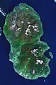
The island lies in the Firth of Clyde between Ayr and Kintyre. The main village on the island is Brodick (Old Norse: broad bay) to which the main ferry to the mainland connects. Brodick Castle is a seat of the Dukes of Hamilton. Arran has many mountains in the north. The highest of these is Goat Fell at 874 metres (2,867 ft). The north of the island has many raised beaches and tall sea cliffs. The island is sometimes referred to as "Scotland in miniature", as it is divided into "Highland" and "Lowland" areas by the Highland Boundary Fault which runs northeast to southwest across Scotland. The island is a popular destination for geologists, who come to see intrusive igneous landforms such as sills and dykes as well as sedimentary and metasedimentary rocks ranging in age from Precambrian to Mesozoic. Most of the interior of the northern half of the island is taken up by a large granite batholith, as seen in the satellite photo.
There are three main roads on the island; the coast road circumnavigates the island, while the String and the Ross both cut across the hilly interior at different points.
King's Cave is an example of an emergent landform. This cave is exposed above the present day sea level due to isostasy.[6]
Villages on Arran
Arran has a number of villages that are mainly dotted around the shoreline. The 'capital' is Brodick(site of the ferry terminal, most hotels and the majority of shops), although Lamlash is actually the largest village on the island. (In 2001 the former's population was 621 and Lamlash's was 1,010.)[7]
For details of the 15 others (from Kildonan in the south to Lochranza in the north) refer to the category above.
Islands surrounding Arran
Arran is a part of an Island group, comprising Arran, Bute, and Large Cumbrae, which are inhabited. Small Cumbrae, Inchmarnock and the Burnt islands are smaller uninhabited islands in the group.
Arran has three smaller satellite islands;
- Holy Isle lies to the east opposite Lamlash
- Pladda lies off Arran's south coast
- Tiny Hamilton Isle lies just off the Arran shore around 1.2 kilometres north of Holy Isle.
Eilean na h-Airde Baine off the south west of Arran at Corriecravie is more of a skerry than an island and, in any case, is connected to Arran at low tide.
History

There are many stone circles and standing stones dating from neolithic times, including the standing stones on Machrie Moor and the Giant's Graves above Whiting Bay. St. Molio's Cave has wall carvings which are evidence of a rare Pictish script.
It is likely that along with Bute, Arran was once the home of a Brythonic speaking people. However, the Gaels spread to the island from their adjacent kingdom of Dál Riata and replaced the older language with their Goidelic tongue. Later the island, along with the vast majority of the Scottish islands, became the property of the Norwegian crown. As a result, many current place names on Arran are of Viking origin. Haakon IV of Norway visited the island in 1263 en route to the Battle of Largs.
St. Columba and St. Ninian are said to have stayed on Arran, and there are other Irish connections, e.g. a stone circle named Fingal's Cauldron. Nearby is the 34 metres deep King's Cave where Robert the Bruce is said to have taken shelter.
This section needs expansion. You can help by adding to it. (June 2008) |
Transport
Arran is connected with the Scottish mainland by two Caledonian MacBrayne ferries:
- Brodick to Ardrossan, Ayrshire, from the east coast of the island.
- Lochranza to Claonaig, Argyll, from the north of the island.
A third ferry route connects Lamlash to neighbouring Holy Isle during summertime.
In summer the paddle steamer PS Waverley calls in at Brodick on regular cruises.
The island has a main road running around the coast, the A841.
Economy
The main industry for the island is tourism. The main tourist spot on the island is the imposing Brodick Castle, owned by the National Trust for Scotland. The Auchrannie Resort, which contains 2 hotels, 3 restaurants and 2 leisure complexes, is one of biggest employers on island.[8]
Local businesses include the Arran Distillery, which was built in 1991 in Lochranza, and Arran Aromatics, which produces a range of toiletries.
Farming and forestry are other important industries. 2008 plans for a large salmon farm holding 800,000 or more fish in Lamlash Bay have been criticised by the Community of Arran Seabed Trust. They fear the facility could jeopardise Scotland's first community marine conservation area, which is planned for the same location.[9]
Arran Brewery
The Arran Brewery is a small brewery founded in March 2000 in Cladach, near Brodick.
The brewery produces three regular cask and bottled beers: Arran Ale 3.8% abv, Arran Dark 4.3% and the wheat beer Arran Blonde 5.0%; in addition to two seasonals - one in summer and in winter - the dark and gingery Arran Fireside. The most popular beer is the Arran Blonde.[10]
Sadly the Arran Brewery went into liquidation in May 2008 [11].
The Brewery was sold to Marketing Management Services International Limited on 17th Jun 2008, with a view to resume production shortly thereafter. They hope that a new marketing strategy and a new local team will revive and develop the brand. [12].
The brewery is now back in production and beer flowing.
Notable residents
- Jack McConnell, Former First Minister of Scotland.
- Jakki Brambles, GMTV & Loose Women presenter.
- Robert McLellan, Scots playwright and poet.
Micro history
- Brodick Castle features on the Royal Bank of Scotland £20 note
- Lochranza Castle was used as the model for the castle in the Tintin adventure The Black Island.
- There are 42 red post boxes on the Isle of Arran
- The Bishop of Sodor and Man refers to the sodor or southern isles, Arran being one, which used to belong to the bishop's see.
- The island has three endemic species of tree, the Arran Whitebeams which grow nowhere else in the World.[13]
- The Scottish Gaelic dialect of Arran died out when the last speaker Donald Craig died in the 1970s. However, there is now a Gaelic House in Brodick, set up at the end of the 1990s
- The last force-fire in the Isle of Arran was about 1820.
- The knitting style used to create Aran sweaters is often mistakenly associated with the Isle of Arran rather than the Irish Aran Islands.[14]
- Arran's local newspaper, The Arran Banner, was listed in the Guinness Book of Records in November 1984 under the ‘Newspaper Records’ section. Under the sub-heading of ‘Most read’ it was entered under the title of ‘local newspaper which achieves the closest to a saturation circulation in its area.’ The entry reads: ‘The Arran Banner, founded in 1974, has a readership of more than 97 per cent in Britain’s seventh largest off-shore island.’
References
- ^ a b Area and population ranks: there are c. 300 islands over 20 ha in extent and 93 permanently inhabited islands were listed in the 2011 census.
- ^ 2001 UK Census per List of islands of Scotland
- ^ Haswell-Smith, Hamish. (2004) The Scottish Islands. Edinburgh. Canongate.
- ^ Ordnance Survey
- ^ Anderson, Joseph (Ed.) (1893) Orkneyinga Saga. Translated by Jón A. Hjaltalin & Gilbert Goudie. Edinburgh. James Thin and Mercat Press (1990 reprint). ISBN 0-901824-25-9
- ^ Geology of Arran
- ^ "Scrol Browser" Scotland's Census Results Online. Retrieved 8 March 2008.
- ^ "Auchrannie Resort on the Isle of Arran" www.auchrannie.co.uk. Retrieved 1 March 2008
- ^ Ross, John (27 February 2008) "Fish-farm plan sparks fears for marine reserve". Edinburgh. The Scotsman.
- ^ Home Page Isle of Arran Brewery.
- ^ "The Publican".
{{cite web}}: Unknown parameter|accessdaymonth=ignored (help); Unknown parameter|accessyear=ignored (|access-date=suggested) (help) - ^ "Cheers! We're back in business".
{{cite web}}: Unknown parameter|accessdaymonth=ignored (help); Unknown parameter|accessyear=ignored (|access-date=suggested) (help) - ^ Johnston, Ian (15 June 2007). "Trees on Arran 'are a whole new species'". The Scotsman. Edinburgh. Retrieved 2007-06-18.
- ^ "Grail Trail". Daily Telegraph. Retrieved 2007-08-03.
Further Reading
- Walking in the Isle of Arran, Paddy Dillon. Cicerone 2006 ISBN 978 1 85284 478 3
Gallery
-
 Sunset over Goat Fell
 -
 Arran's location within Ayrshire
 -
 PS Waverley in front of Brodick Castle.
 -
-
 The peaks of north Arran seen over the Isle of Bute from a farm in North Ayrshire.
 -
 MV Isle of Arran was built for the island ferry service.
 -
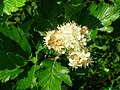 Sorbus arranensis in flower at Eglinton Country Park, Irvine. This is one of the islands unique species of Arran Whitebeams


External links
- Template:Wikitravel
- Arran seen from space, NASA
- Arran.info - The Isle of Arran Interactive Guide Tourism-related Information and Virtual Tour of Arran
- Isle of Arran Tour and Information
- The Isle of Arran Tourism Directory
- The Isle of Arran Heritage Museum
- The Arran Banner Arran's local newspaper
- Auchrannie Resort Local Tourist Resort & Major Island Employer
- Arran High School